TopoQuest Logo
Do you find TopoQuest useful?
Help keep TopoQuest running and adding new maps/features by donating!
Bitcoin:  19c7KJd3qBynnjoSw5npx9KScwjBe4ifkT
Litecoin:  LXs6TkuXGGXo1vDsWCkWVdjQX94eUKd6ui
Home View Maps Find Maps Find Places Resources & Links


Fulton, Mississippi Topographic Map

USGS Map Title: Fulton, MS
USGS Map MRC: 34088C4
DRG (GeoTIFF) Download: o34088c4.tif


Neighboring USGS Topographic Map Quads:


  Ratliff, MS  
34088D5
 

  Kirkville, MS  
34088D4
 

  Fulton NE, MS  
34088D3
 

  Mooreville, MS  
34088C5
 

  Fulton, MS  
34088C4
 

  Fulton SE, MS  
34088C3
 

  Evergreen, MS  
34088B5
 

  Beans Ferry, MS  
34088B4
 

  Tremont, MS  
34088B3


Map MRC Location:

N35°
W89°
N35°
W88°
H8 H7 H6 H5 H4 H3 H2 H1
G8 G7 G6 G5 G4 G3 G2 G1
F8 F7 F6 F5 F4 F3 F2 F1
E8 E7 E6 E5 E4 E3 E2 E1
D8 D7 D6 D5 D4 D3 D2 D1
C8 C7 C6 C5 C4 C3 C2 C1
B8 B7 B6 B5 B4 B3 B2 B1
A8 A7 A6 A5 A4 A3 A2 A1
N34°
W89°
N34°
W88°

Fulton, MS USGS 1:24K Topographic Map Preview:
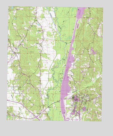
Fulton, MS USGS Topographic Map
Click on map above to begin viewing in our Map Viewer.

This topographic map contains these locations and features:
Feature Name Type Latitude Longitude GNIS ID View Map
Bethel Baptist ChurchChurchN34.2590°W88.4962°666954View Map
Buck Riley Lake DamDamN34.2684°W88.4717°682542View Map
Bullger CreekStreamN34.2843°W88.4995°667778View Map
Christ the King Catholic ChurchChurchN34.2737°W88.4070°683687View Map
City of FultonCivilN34.2616°W88.4021°2403670View Map
Cummings CreekStreamN34.2887°W88.4337°669018View Map
Dorsey - Friendship Fire Department Dorsey StationBuildingN34.2552°W88.4938°2666032View Map
Dorsey - Friendship Fire Department HeadquartersBuildingN34.2721°W88.4548°2666067View Map
Dorsey Memorial CemeteryCemeteryN34.2554°W88.4953°669337View Map
East High SchoolSchoolN34.2776°W88.3931°706223View Map
Files CemeteryCemeteryN34.2854°W88.4839°669959View Map
First Baptist ChurchChurchN34.2726°W88.4098°683691View Map
Friendship ChurchChurchN34.2579°W88.4573°670243View Map
FultonPopulated PlaceN34.2740°W88.4092°670269View Map
Fulton - Greater Fulton Fire DepartmentBuildingN34.2659°W88.4028°2665762View Map
Fulton CemeteryCemeteryN34.2732°W88.4012°706228View Map
Fulton Church of ChristChurchN34.2695°W88.4084°683692View Map
Fulton Elementary SchoolSchoolN34.2676°W88.4095°706229View Map
Fulton Freewill Baptist ChurchChurchN34.2748°W88.3862°670272View Map
Fulton Junior High SchoolSchoolN34.2751°W88.4117°706230View Map
Fulton Police DepartmentBuildingN34.2729°W88.4088°2754263View Map
Fulton Post OfficePost OfficeN34.2731°W88.4070°2768712View Map
Fulton Recreation AreaParkN34.3015°W88.4167°683693View Map
Fulton-Itawamba County Airport (historical)AirportN34.3520°W88.3773°680428View Map
Graham Lake DamDamN34.3418°W88.4517°682587View Map
Greater Mantachie Fire and Rescue Station 200BuildingN34.3143°W88.4986°2666033View Map
Ita (historical)LocaleN34.3640°W88.3928°706236View Map
Itawamba Agricultural High SchoolSchoolN34.2748°W88.4153°706237View Map
Itawamba County HospitalHospitalN34.2607°W88.3992°706238View Map
Itawamba County Sheriff's OfficeBuildingN34.2730°W88.4098°2754149View Map
Itawamba Junior CollegeSchoolN34.2765°W88.4125°706239View Map
Itawamba Vocational Technical CenterSchoolN34.2848°W88.4145°706240View Map
Lake ItawambaReservoirN34.3267°W88.3869°671748View Map
Lake Itawamba DamDamN34.3318°W88.3900°682585View Map
Lakeland ChurchChurchN34.3590°W88.4617°672267View Map
Liberty ChurchChurchN34.2984°W88.4823°672456View Map
MantachiePopulated PlaceN34.3243°W88.4912°673115View Map
Mantachie CemeteryCemeteryN34.3307°W88.4970°706248View Map
Mantachie First Baptist ChurchChurchN34.3257°W88.4942°683700View Map
Mantachie Police DepartmentBuildingN34.3174°W88.4922°2754213View Map
Mantachie Post OfficePost OfficeN34.3225°W88.4884°2768811View Map
Mantachie SchoolSchoolN34.3287°W88.4895°706249View Map
Mount Pisgah CemeteryCemeteryN34.3254°W88.4706°674195View Map
Mount Pisgah ChurchChurchN34.3426°W88.4850°674208View Map
Mount Vernon Baptist ChurchChurchN34.3643°W88.3925°674308View Map
Mud CreekStreamN34.3495°W88.4300°674434View Map
New Hope ChurchChurchN34.2834°W88.4856°674739View Map
Old River CutoffLakeN34.3179°W88.4239°675234View Map
Pearce Lake DamDamN34.3534°W88.4584°682598View Map
Pleasant Hill ChurchChurchN34.2904°W88.4700°676082View Map
Queen LakeLakeN34.3016°W88.4262°676430View Map
Rayburnville (historical)LocaleN34.3307°W88.3834°706267View Map
Ryans Well Volunteer Fire Department Station 2BuildingN34.3664°W88.3915°2666084View Map
Saint Matthew Baptist ChurchChurchN34.2784°W88.3981°683707View Map
Scenic Hills Club Lake DamDamN34.2951°W88.4034°682562View Map
Shiloh Christian Methodist Episcopal ChurchChurchN34.2793°W88.3984°690958View Map
South Side Baptist ChurchChurchN34.2640°W88.4109°683709View Map
Stephens ChurchChurchN34.3487°W88.4570°678272View Map
Stevens CemeteryCemeteryN34.3484°W88.4567°706273View Map
Tombigbee ChurchChurchN34.3348°W88.4589°678807View Map
Town of MantachieCivilN34.3251°W88.4961°2406090View Map
Trinity Baptist ChurchChurchN34.2712°W88.4017°683714View Map
Twentymile CreekStreamN34.3454°W88.4314°678998View Map
Walton CemeteryCemeteryN34.2779°W88.4795°679317View Map
Warren Chapel CemeteryCemeteryN34.3712°W88.4887°706279View Map
Warrens ChapelChurchN34.3712°W88.4892°679354View Map
West FultonPopulated PlaceN34.2709°W88.4542°707315View Map
Wilber Stephens Pond DamDamN34.3668°W88.4650°682607View Map

Note: Coordinates in the location and feature list above are referenced to NAD83 datum.


Copyright (C) 2008-2024 Ryan Niemi / Sunset Dynamics ... All Rights Reserved