TopoQuest Logo
Do you find TopoQuest useful?
Help keep TopoQuest running and adding new maps/features by donating!
Bitcoin:  19c7KJd3qBynnjoSw5npx9KScwjBe4ifkT
Litecoin:  LXs6TkuXGGXo1vDsWCkWVdjQX94eUKd6ui
Home View Maps Find Maps Find Places Resources & Links


Kirkville, Mississippi Topographic Map

USGS Map Title: Kirkville, MS
USGS Map MRC: 34088D4
DRG (GeoTIFF) Download: o34088d4.tif


Neighboring USGS Topographic Map Quads:


  Wheeler, MS  
34088E5
 

  Marietta, MS  
34088E4
 

  Paden SE, MS  
34088E3
 

  Ratliff, MS  
34088D5
 

  Kirkville, MS  
34088D4
 

  Fulton NE, MS  
34088D3
 

  Mooreville, MS  
34088C5
 

  Fulton, MS  
34088C4
 

  Fulton SE, MS  
34088C3


Map MRC Location:

N35°
W89°
N35°
W88°
H8 H7 H6 H5 H4 H3 H2 H1
G8 G7 G6 G5 G4 G3 G2 G1
F8 F7 F6 F5 F4 F3 F2 F1
E8 E7 E6 E5 E4 E3 E2 E1
D8 D7 D6 D5 D4 D3 D2 D1
C8 C7 C6 C5 C4 C3 C2 C1
B8 B7 B6 B5 B4 B3 B2 B1
A8 A7 A6 A5 A4 A3 A2 A1
N34°
W89°
N34°
W88°

Kirkville, MS USGS 1:24K Topographic Map Preview:
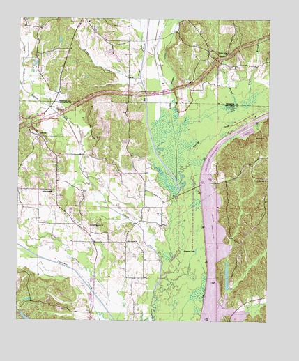
Kirkville, MS USGS Topographic Map
Click on map above to begin viewing in our Map Viewer.

This topographic map contains these locations and features:
Feature Name Type Latitude Longitude GNIS ID View Map
Beaver LakeLakeN34.3929°W88.3951°666714View Map
Beaver Lake DamDamN34.3951°W88.3967°682624View Map
Beaver Lake Recreation AreaParkN34.3945°W88.3931°683685View Map
Big Brown CreekStreamN34.4290°W88.4195°667090View Map
Bud Isaiah Lake DamDamN34.3784°W88.4967°682612View Map
Casey CreekStreamN34.4718°W88.4989°668135View Map
Cummings (historical)LocaleN34.3951°W88.4792°683688View Map
Donivan CreekStreamN34.3937°W88.4281°669328View Map
Elfin (historical)LocaleN34.4320°W88.4042°706224View Map
Ferguson LakeLakeN34.4040°W88.4107°669948View Map
Fret BranchStreamN34.4532°W88.4225°670204View Map
Gilmers ChapelChurchN34.4507°W88.4595°670398View Map
Gilmore Chapel CemeteryCemeteryN34.4506°W88.4612°706231View Map
Granny CreekStreamN34.4757°W88.4395°670589View Map
HazeldellPopulated PlaceN34.4807°W88.3931°690944View Map
Houston SchoolSchoolN34.4282°W88.4834°671522View Map
Jericho (historical)LocaleN34.4190°W88.4278°706241View Map
John Bell Williams Wildlife Management AreaParkN34.4501°W88.4334°683698View Map
KirkvillePopulated PlaceN34.4515°W88.4898°672191View Map
Kirkville Baptist ChurchChurchN34.4498°W88.4867°683699View Map
Kirkville CemeteryCemeteryN34.4484°W88.4862°706244View Map
Little Brown CreekStreamN34.4332°W88.4209°672559View Map
Mackeys CreekStreamN34.4290°W88.4198°673043View Map
Marietta High SchoolSchoolN34.4987°W88.4653°711692View Map
OzarkPopulated PlaceN34.4140°W88.4695°683702View Map
Ozark Baptist ChurchChurchN34.4079°W88.4456°675360View Map
Ozark CemeteryCemeteryN34.4151°W88.4634°706263View Map
Ozark Church of ChristChurchN34.4162°W88.4720°675361View Map
Ozark Methodist ChurchChurchN34.4143°W88.4631°675365View Map
Pharr FlatsFlatN34.4682°W88.4167°706200View Map
Pharr MoundsSummitN34.4665°W88.4167°706201View Map
Pleasant Valley CemeteryCemeteryN34.4862°W88.3959°706203View Map
Pleasant Valley ChurchChurchN34.4865°W88.3962°676148View Map
Pleasant View (historical)LocaleN34.4859°W88.3962°683663View Map
Sandy SpringsPopulated PlaceN34.4329°W88.3750°677397View Map
Sandy Springs CemeteryCemeteryN34.4373°W88.3756°706271View Map
Supervisor District 2CivilN34.3818°W88.4756°711896View Map
Town of MariettaCivilN34.5000°W88.4726°2406096View Map
Tynes BranchStreamN34.3787°W88.4542°679017View Map
Walkers BridgeBridgeN34.4265°W88.4212°683716View Map
Walkers Ferry (historical)CrossingN34.3907°W88.4289°683717View Map
Warren CemeteryCemeteryN34.4512°W88.3814°679352View Map
Wesson BranchStreamN34.4709°W88.4242°679463View Map
Wright BranchStreamN34.4659°W88.3878°679889View Map

Note: Coordinates in the location and feature list above are referenced to NAD83 datum.


Copyright (C) 2008-2025 Ryan Niemi / Sunset Dynamics ... All Rights Reserved