TopoQuest Logo
Do you find TopoQuest useful?
Help keep TopoQuest running and adding new maps/features by donating!
Bitcoin:  19c7KJd3qBynnjoSw5npx9KScwjBe4ifkT
Litecoin:  LXs6TkuXGGXo1vDsWCkWVdjQX94eUKd6ui
Home View Maps Find Maps Find Places Resources & Links


Hahira East, Georgia Topographic Map

USGS Map Title: Hahira East, GA
USGS Map MRC: 30083H3
DRG (GeoTIFF) Download: o30083h3.tif


Neighboring USGS Topographic Map Quads:


  Cecil, GA  
31083A4
 

  New Lois, GA  
31083A3
 

  Ray City, GA  
31083A2
 

  Hahira West, GA  
30083H4
 

  Hahira East, GA  
30083H3


  Ousley, GA  
30083G4
 

  Valdosta, GA  
30083G3


Map MRC Location:

N31°
W84°
N31°
W83°
H8 H7 H6 H5 H4 H3 H2 H1
G8 G7 G6 G5 G4 G3 G2 G1
F8 F7 F6 F5 F4 F3 F2 F1
E8 E7 E6 E5 E4 E3 E2 E1
D8 D7 D6 D5 D4 D3 D2 D1
C8 C7 C6 C5 C4 C3 C2 C1
B8 B7 B6 B5 B4 B3 B2 B1
A8 A7 A6 A5 A4 A3 A2 A1
N30°
W84°
N30°
W83°

Hahira East, GA USGS 1:24K Topographic Map Preview:
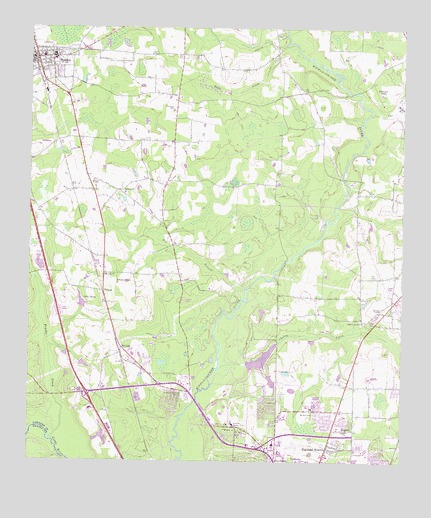
Hahira East, GA USGS Topographic Map
Click on map above to begin viewing in our Map Viewer.

This topographic map contains these locations and features:
Feature Name Type Latitude Longitude GNIS ID View Map
Barko VillagePopulated PlaceN30.9044°W83.3349°346200View Map
Bay BranchStreamN30.9219°W83.3032°310873View Map
Beatty BranchStreamN30.9783°W83.2521°310966View Map
Bethany ChurchChurchN30.9524°W83.3427°354567View Map
Cat CreekStreamN30.9755°W83.2613°312416View Map
Cherokee PlantationPopulated PlaceN30.8905°W83.3118°346214View Map
Cherry CreekStreamN30.9019°W83.3107°312615View Map
Cherry Creek ChurchChurchN30.9158°W83.2627°355138View Map
Cherry Creek HillsPopulated PlaceN30.9085°W83.2985°346215View Map
Cherry LakeReservoirN30.9048°W83.2967°338350View Map
Cherry Lake DamDamN30.9019°W83.3015°338349View Map
Country Club EstatesPopulated PlaceN30.8824°W83.3082°346230View Map
Double BridgesBridgeN30.8927°W83.3188°346236View Map
EastwindPopulated PlaceN30.8777°W83.2582°346239View Map
Exit 6CrossingN30.8946°W83.3552°1672940View Map
Five Points Shopping CenterLocaleN30.8766°W83.2896°346249View Map
FoxboroughPopulated PlaceN30.8924°W83.3252°346255View Map
FranklinvillePopulated PlaceN30.9821°W83.2832°346257View Map
Franks CreekStreamN30.8808°W83.3665°314355View Map
HahiraPopulated PlaceN30.9913°W83.3727°315009View Map
Hahira DivisionCivilN30.9584°W83.3653°1936302View Map
Hahira Elementary SchoolSchoolN30.9924°W83.3674°346262View Map
Hahira Middle SchoolSchoolN30.9910°W83.3671°346263View Map
Hahira Police DepartmentBuildingN30.9910°W83.3729°2733687View Map
Hahira Volunteer Fire DepartmentBuildingN30.9918°W83.3714°2603870View Map
Highland HeightsPopulated PlaceN30.8791°W83.2746°331979View Map
Hodges CemeteryCemeteryN30.9560°W83.3534°315484View Map
Hodges PondLakeN30.9974°W83.3640°315493View Map
Jerusalem ChurchChurchN30.8841°W83.2682°316090View Map
Lake NevaReservoirN30.9217°W83.3574°319256View Map
LowndesSchoolN30.8849°W83.2718°346289View Map
MineolaPopulated PlaceN30.9077°W83.3435°332399View Map
Mobile Home EstatesPopulated PlaceN30.8808°W83.2957°346300View Map
Mount Airy ChurchChurchN30.9285°W83.3496°318544View Map
Mount Moriah Church (historical)ChurchN30.9224°W83.3393°346302View Map
Mount Zion ChurchChurchN30.8888°W83.2796°318932View Map
North Gate Manor Trailer ParkPopulated PlaceN30.8994°W83.3215°346309View Map
North Lowndes Volunteer Fire Department Station 4BuildingN30.9052°W83.3411°2604868View Map
North Lowndes Volunteer Fire Department Station 4ABuildingN30.9929°W83.3238°2603623View Map
North Valdosta ChurchChurchN30.8896°W83.2665°346311View Map
Northlake Golf and Country Club (historical)LocaleN30.8994°W83.3554°346312View Map
NorthwoodPopulated PlaceN30.8760°W83.2999°346313View Map
OakPopulated PlaceN30.8880°W83.2760°346314View Map
Open Bible Christian SchoolSchoolN30.8906°W83.2801°346317View Map
Passmore CemeteryCemeteryN30.9771°W83.3268°320255View Map
Peace Freewill ChurchChurchN30.8985°W83.3499°346320View Map
Riverview Memorial GardenCemeteryN30.8941°W83.3221°321653View Map
Robinson PondLakeN30.9815°W83.2573°321699View Map
Rocky Hill ChurchChurchN30.9271°W83.3449°321846View Map
Schoer EstatesPopulated PlaceN30.8869°W83.2690°346341View Map
Skipper BridgeBridgeN30.9571°W83.2699°346347View Map
Smith HospitalHospitalN30.9921°W83.3707°346348View Map
Smith Northview HospitalHospitalN30.8987°W83.3356°2611023View Map
South Ree SpringsPopulated PlaceN30.8755°W83.2690°346387View Map
TillmanPopulated PlaceN30.9241°W83.3496°333233View Map
Tillman Lake DamDamN30.9194°W83.3560°340874View Map
Twin CreekStreamN30.9935°W83.2846°324444View Map
Tyler BridgeBridgeN30.9813°W83.2679°346360View Map
Tylers PondSwampN30.9529°W83.3703°346361View Map
Valdosta Area Vocational Technical SchoolSchoolN30.8902°W83.3540°346388View Map
Valdosta Country ClubLocaleN30.8860°W83.3057°344373View Map
Valdosta Fire Department Station 5BuildingN30.8845°W83.2911°2604481View Map
Valdosta High SchoolSchoolN30.8797°W83.2637°346366View Map
Windsor ParkPopulated PlaceN30.8916°W83.2938°346380View Map
WMDE-AM (Remerton)TowerN30.8796°W83.3479°352524View Map

Note: Coordinates in the location and feature list above are referenced to NAD83 datum.


Copyright (C) 2008-2025 Ryan Niemi / Sunset Dynamics ... All Rights Reserved