TopoQuest Logo
Do you find TopoQuest useful?
Help keep TopoQuest running and adding new maps/features by donating!
Bitcoin:  19c7KJd3qBynnjoSw5npx9KScwjBe4ifkT
Litecoin:  LXs6TkuXGGXo1vDsWCkWVdjQX94eUKd6ui
Home View Maps Find Maps Find Places Resources & Links


Reading Mountain, New Mexico Topographic Map

USGS Map Title: Reading Mountain, NM
USGS Map MRC: 32108H3
DRG (GeoTIFF) Download: o32108h3.tif


Neighboring USGS Topographic Map Quads:


  Canyon Hill, NM  
33108A4
 

  Granny Mountain, NM  
33108A3
 

  Copperas Peak, NM  
33108A2
 

  Dorsey Ranch, NM  
32108H4
 

  Reading Mountain, NM  
32108H3
 

  Twin Sisters, NM  
32108H2
 

  Circle Mesa, NM  
32108G4
 

  Silver City, NM  
32108G3
 

  Fort Bayard, NM  
32108G2


Map MRC Location:

N33°
W109°
N33°
W108°
H8 H7 H6 H5 H4 H3 H2 H1
G8 G7 G6 G5 G4 G3 G2 G1
F8 F7 F6 F5 F4 F3 F2 F1
E8 E7 E6 E5 E4 E3 E2 E1
D8 D7 D6 D5 D4 D3 D2 D1
C8 C7 C6 C5 C4 C3 C2 C1
B8 B7 B6 B5 B4 B3 B2 B1
A8 A7 A6 A5 A4 A3 A2 A1
N32°
W109°
N32°
W108°

Reading Mountain, NM USGS 1:24K Topographic Map Preview:
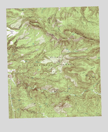
Reading Mountain, NM USGS Topographic Map
Click on map above to begin viewing in our Map Viewer.

This topographic map contains these locations and features:
Feature Name Type Latitude Longitude GNIS ID View Map
A Four MountainSummitN32.9353°W108.2500°902876View Map
Allen SpringSpringN32.8855°W108.3615°903103View Map
Arroyo RicoStreamN32.8798°W108.2798°903411View Map
Bear Creek SpringSpringN32.9075°W108.2947°900201View Map
Big Trap SpringSpringN32.9522°W108.2937°900203View Map
Bobtail MesaSummitN32.9487°W108.3734°903981View Map
Buckwood MesaSummitN32.9303°W108.3739°900236View Map
Cave CanyonValleyN32.9248°W108.3570°904843View Map
Cave SpringSpringN32.8911°W108.3238°900205View Map
Cave Spring CanyonValleyN32.9048°W108.3298°899136View Map
Cherry CreekStreamN32.8995°W108.2514°905076View Map
Cherry Creek CanyonValleyN32.8995°W108.2514°905079View Map
Clark SpringSpringN32.8976°W108.3436°900207View Map
Cooley SpringSpringN32.9212°W108.3414°900208View Map
Cooley TankReservoirN32.9294°W108.3329°900209View Map
Devils GardenSummitN32.9398°W108.3067°905738View Map
Fenceline SpringSpringN32.8881°W108.3345°900212View Map
Goat CanyonValleyN32.9923°W108.3109°906578View Map
Hells Canyon SpringSpringN32.9355°W108.2962°936766View Map
Hidden SpringSpringN32.9565°W108.3400°936757View Map
Holman SpringSpringN32.9483°W108.3687°900214View Map
Holmon SpringSpringN32.9465°W108.3687°936759View Map
Homon SpringSpringN32.9465°W108.3687°936758View Map
Horseshoe BendBendN32.9037°W108.3128°907115View Map
Juniper HillSummitN32.8915°W108.3328°907487View Map
Little Pipe SpringSpringN32.9217°W108.2680°900215View Map
Little Pipeline SpringSpringN32.9215°W108.2642°936764View Map
Long GulchValleyN32.9015°W108.2578°908167View Map
Lower Cave Creek SpringSpringN32.9278°W108.3506°936760View Map
Moore CanyonValleyN32.9401°W108.3020°908887View Map
Moore SpringSpringN32.9409°W108.2508°900217View Map
Moore TankReservoirN32.9054°W108.2604°899139View Map
North Fork Walnut CreekStreamN32.8842°W108.3698°924247View Map
Pipeline SpringSpringN32.9199°W108.2589°900219View Map
Pipeline SpringSpringN32.8959°W108.3596°900220View Map
Pipeline SpringSpringN32.9015°W108.3612°936761View Map
Preachers PointSummitN32.8962°W108.2964°920669View Map
Quartzite TankReservoirN32.9120°W108.3295°2038636View Map
Reading MesaSummitN32.9742°W108.3634°900249View Map
Reading MountainSummitN32.9817°W108.3350°910035View Map
Salt MesaSummitN32.9448°W108.3450°900221View Map
Salt Mesa SpringSpringN32.9399°W108.3492°900222View Map
Salt Mesa SpringSpringN32.9506°W108.3206°936762View Map
Sawmill SpringSpringN32.9982°W108.3548°900223View Map
Snow Creek CabinLocaleN32.9995°W108.3264°911177View Map
Snow Creek SpringSpringN32.9992°W108.3256°899135View Map
Snow Creek TankReservoirN32.9928°W108.3278°2038684View Map
Snow Creek TrailTrailN32.9798°W108.2806°899288View Map
Sycamore CreekStreamN32.9201°W108.3714°911513View Map
Sycamore SpringSpringN32.9340°W108.3123°936763View Map
Tadpole LakeLakeN32.9676°W108.2859°936765View Map
Tadpole RidgeRidgeN32.9620°W108.2642°911526View Map
Turkey CanyonValleyN32.9220°W108.3392°911859View Map
Turkey FlatFlatN32.9270°W108.3145°899138View Map
Upper Cave Creek SpringSpringN32.9392°W108.3375°900228View Map
Walnut CreekStreamN32.9198°W108.3725°924245View Map
Walnut Creek SpringSpringN32.8978°W108.3723°900229View Map
Webb GulchValleyN32.8992°W108.2867°912195View Map
Wilson CreekStreamN32.9056°W108.2634°912429View Map

Note: Coordinates in the location and feature list above are referenced to NAD83 datum.


Copyright (C) 2008-2025 Ryan Niemi / Sunset Dynamics ... All Rights Reserved