TopoQuest Logo
Do you find TopoQuest useful?
Help keep TopoQuest running and adding new maps/features by donating!
Bitcoin:  19c7KJd3qBynnjoSw5npx9KScwjBe4ifkT
Litecoin:  LXs6TkuXGGXo1vDsWCkWVdjQX94eUKd6ui
Home View Maps Find Maps Find Places Resources & Links


Red Bluff West, California Topographic Map

USGS Map Title: Red Bluff West, CA
USGS Map MRC: 40122B3
DRG (GeoTIFF) Download: o40122b3.tif


Neighboring USGS Topographic Map Quads:


  Mitchell Gulch, CA  
40122C4
 

  Hooker, CA  
40122C3
 

  Bend, CA  
40122C2
 

  Blossom, CA  
40122B4
 

  Red Bluff West, CA  
40122B3
 

  Red Bluff East, CA  
40122B2
 

  Red Bank, CA  
40122A4
 

  West of Gerber, CA  
40122A3
 

  Gerber, CA  
40122A2


Map MRC Location:

N41°
W123°
N41°
W122°
H8 H7 H6 H5 H4 H3 H2 H1
G8 G7 G6 G5 G4 G3 G2 G1
F8 F7 F6 F5 F4 F3 F2 F1
E8 E7 E6 E5 E4 E3 E2 E1
D8 D7 D6 D5 D4 D3 D2 D1
C8 C7 C6 C5 C4 C3 C2 C1
B8 B7 B6 B5 B4 B3 B2 B1
A8 A7 A6 A5 A4 A3 A2 A1
N40°
W123°
N40°
W122°

Red Bluff West, CA USGS 1:24K Topographic Map Preview:
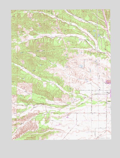
Red Bluff West, CA USGS Topographic Map
Click on map above to begin viewing in our Map Viewer.

This topographic map contains these locations and features:
Feature Name Type Latitude Longitude GNIS ID View Map
BluntPopulated PlaceN40.2418°W122.2911°1658088View Map
Brush CreekStreamN40.1577°W122.3053°219930View Map
Lincoln SchoolSchoolN40.1652°W122.2828°227153View Map
Liza CreekStreamN40.1579°W122.3386°227436View Map
Marion School (historical)SchoolN40.2215°W122.2742°1666622View Map
Meadow Airstrip (historical)AirportN40.1568°W122.3024°1653861View Map
North Fork Dibble CreekStreamN40.2115°W122.2683°229665View Map
Pine CreekStreamN40.1638°W122.2797°230682View Map
Red Bluff Air Force Station (historical)MilitaryN40.1447°W122.3075°2086565View Map
Red Bluff DivisionCivilN40.2080°W122.2665°1935261View Map
Red Bluff Municipal AirportAirportN40.1552°W122.2518°1653859View Map
Reeds Creek Elementary SchoolSchoolN40.1561°W122.3553°231466View Map
Ridgeway ParkParkN40.1457°W122.3072°1692706View Map
Saint Marys CemeteryCemeteryN40.1715°W122.2533°232212View Map
South Fork Dibble CreekStreamN40.2115°W122.2683°234995View Map
Tehama County Fire Department Station 14 Dibble CreekBuildingN40.2209°W122.2837°2622058View Map
Tehama County Fire Department Station 4 RidgewayBuildingN40.1473°W122.3060°2622099View Map
Tehama County Health CenterHospitalN40.1697°W122.2549°1692713View Map
Tehama County LandfillLocaleN40.1956°W122.2981°2726427View Map
Wilcox Oaks Golf CourseLocaleN40.2224°W122.2589°1654517View Map

Note: Coordinates in the location and feature list above are referenced to NAD83 datum.


Copyright (C) 2008-2025 Ryan Niemi / Sunset Dynamics ... All Rights Reserved