TopoQuest Logo
Do you find TopoQuest useful?
Help keep TopoQuest running and adding new maps/features by donating!
Bitcoin:  19c7KJd3qBynnjoSw5npx9KScwjBe4ifkT
Litecoin:  LXs6TkuXGGXo1vDsWCkWVdjQX94eUKd6ui
Home View Maps Find Maps Find Places Resources & Links


Redfield, Arkansas Topographic Map

USGS Map Title: Redfield, AR
USGS Map MRC: 34092D2
DRG (GeoTIFF) Download: o34092d2.tif


Neighboring USGS Topographic Map Quads:


  Spring Lake, AR  
34092E3
 

  Woodson, AR  
34092E2
 

  Keo, AR  
34092E1
 

  Cane Creek, AR  
34092D3
 

  Redfield, AR  
34092D2
 

  Wright, AR  
34092D1
 

  Prague, AR  
34092C3
 

  Hardin, AR  
34092C2
 

  White Hall, AR  
34092C1


Map MRC Location:

N35°
W93°
N35°
W92°
H8 H7 H6 H5 H4 H3 H2 H1
G8 G7 G6 G5 G4 G3 G2 G1
F8 F7 F6 F5 F4 F3 F2 F1
E8 E7 E6 E5 E4 E3 E2 E1
D8 D7 D6 D5 D4 D3 D2 D1
C8 C7 C6 C5 C4 C3 C2 C1
B8 B7 B6 B5 B4 B3 B2 B1
A8 A7 A6 A5 A4 A3 A2 A1
N34°
W93°
N34°
W92°

Redfield, AR USGS 1:24K Topographic Map Preview:
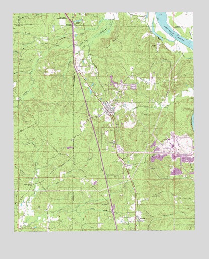
Redfield, AR USGS Topographic Map
Click on map above to begin viewing in our Map Viewer.

This topographic map contains these locations and features:
Feature Name Type Latitude Longitude GNIS ID View Map
Amber (historical)Populated PlaceN34.3770°W92.2376°60619View Map
Barnes CreekStreamN34.4965°W92.1788°46106View Map
Bradley BranchStreamN34.4501°W92.2457°46891View Map
Brush CreekStreamN34.4104°W92.2346°47037View Map
Case CreekStreamN34.3870°W92.2074°47511View Map
City of RedfieldCivilN34.4433°W92.1839°2404603View Map
Clean Water Holding PondReservoirN34.4153°W92.1283°81311View Map
Counterfeit RidgeRidgeN34.4870°W92.2088°48083View Map
Dale CreekStreamN34.3793°W92.1999°48334View Map
Dike Number Two DamDamN34.4134°W92.1285°81310View Map
Dukes BranchStreamN34.4862°W92.2332°48696View Map
English PlacePopulated PlaceN34.3909°W92.1843°57006View Map
Garden Springs ChurchChurchN34.3832°W92.1746°49335View Map
Gropper LakeReservoirN34.4954°W92.2049°75727View Map
Gropper Lake DamDamN34.4959°W92.2018°79553View Map
Happy Home CemeteryCemeteryN34.3801°W92.1699°49840View Map
Hardin Elementary SchoolSchoolN34.4515°W92.1759°2039305View Map
Harris CemeteryCemeteryN34.4965°W92.1635°49894View Map
Harris MountainsSummitN34.4807°W92.1799°57893View Map
Horn BranchStreamN34.4034°W92.2349°50320View Map
Hyde BranchStreamN34.3973°W92.2357°50475View Map
JeffersonPopulated PlaceN34.3807°W92.1640°77370View Map
Jefferson CemeteryCemeteryN34.3760°W92.1687°50604View Map
Jerning BranchStreamN34.4812°W92.2413°50627View Map
Jones CemeteryCemeteryN34.3876°W92.2324°50723View Map
KASN-TV (Pine Bluff)TowerN34.4420°W92.2176°85443View Map
KATV-TV (Little Rock)TowerN34.4732°W92.2032°85441View Map
KearneyPopulated PlaceN34.4132°W92.1721°58006View Map
KETS-TV (Little Rock)TowerN34.4732°W92.2032°85442View Map
KOLL-FM (Pine Bluff)TowerN34.4420°W92.2176°85418View Map
Ledbetter CreekStreamN34.4768°W92.1351°51037View Map
Lou CreekStreamN34.4734°W92.2321°51479View Map
Orion ChurchChurchN34.4568°W92.2499°53071View Map
Patterson BranchStreamN34.4218°W92.2324°53220View Map
Red BluffCliffN34.4809°W92.1457°53930View Map
Red Bluff (historical)Populated PlaceN34.4812°W92.1501°60817View Map
Red Bluff CemeteryCemeteryN34.4795°W92.1524°53934View Map
Red ForkStreamN34.3757°W92.2449°53943View Map
RedfieldPopulated PlaceN34.4451°W92.1832°58477View Map
Redfield CemeteryCemeteryN34.4448°W92.1904°53963View Map
Redfield First Southern Baptist ChurchChurchN34.4454°W92.1829°60699View Map
Redfield Junior High SchoolSchoolN34.4485°W92.1851°60815View Map
Redfield Police DepartmentBuildingN34.4435°W92.1868°2118668View Map
Redfield Volunteer Fire Department Station 1BuildingN34.4469°W92.1844°2117020View Map
Redfield Volunteer Fire Department Station 2BuildingN34.4518°W92.1934°2117021View Map
Rest in Peace Memorial GardensCemeteryN34.4943°W92.2140°53987View Map
Rinehart CreekStreamN34.4837°W92.1949°1867993View Map
River Road ChurchChurchN34.4634°W92.1679°54051View Map
Schoolhouse CreekStreamN34.3820°W92.1532°54623View Map
Shingle Mill LakeSwampN34.4912°W92.1874°54806View Map
Silva School (historical)SchoolN34.4618°W92.1376°60816View Map
Smith CreekStreamN34.3820°W92.1535°54947View Map
Stokes CreekStreamN34.3865°W92.2051°55242View Map
Surge PondReservoirN34.4090°W92.1374°81313View Map
Surge Pond DamDamN34.4068°W92.1351°81312View Map
Township of BarraqueCivilN34.4464°W92.1605°66731View Map
Turkey CreekStreamN34.4845°W92.1943°55714View Map
Walnut RidgePopulated PlaceN34.4020°W92.2376°57230View Map
Ward BranchStreamN34.4662°W92.2371°56038View Map
Weaver CreekStreamN34.4790°W92.2243°56130View Map
White Bluff Power PlantBuildingN34.4233°W92.1403°2392969View Map
Wildcat CreekStreamN34.4962°W92.1854°78772View Map

Note: Coordinates in the location and feature list above are referenced to NAD83 datum.


Copyright (C) 2008-2025 Ryan Niemi / Sunset Dynamics ... All Rights Reserved