TopoQuest Logo
Do you find TopoQuest useful?
Help keep TopoQuest running and adding new maps/features by donating!
Bitcoin:  19c7KJd3qBynnjoSw5npx9KScwjBe4ifkT
Litecoin:  LXs6TkuXGGXo1vDsWCkWVdjQX94eUKd6ui
Home View Maps Find Maps Find Places Resources & Links


Woodson, Arkansas Topographic Map

USGS Map Title: Woodson, AR
USGS Map MRC: 34092E2
DRG (GeoTIFF) Download: o34092e2.tif


Neighboring USGS Topographic Map Quads:


  Little Rock, AR  
34092F3
 

  Sweet Home, AR  
34092F2
 

  Scott, AR  
34092F1
 

  Spring Lake, AR  
34092E3
 

  Woodson, AR  
34092E2
 

  Keo, AR  
34092E1
 

  Cane Creek, AR  
34092D3
 

  Redfield, AR  
34092D2
 

  Wright, AR  
34092D1


Map MRC Location:

N35°
W93°
N35°
W92°
H8 H7 H6 H5 H4 H3 H2 H1
G8 G7 G6 G5 G4 G3 G2 G1
F8 F7 F6 F5 F4 F3 F2 F1
E8 E7 E6 E5 E4 E3 E2 E1
D8 D7 D6 D5 D4 D3 D2 D1
C8 C7 C6 C5 C4 C3 C2 C1
B8 B7 B6 B5 B4 B3 B2 B1
A8 A7 A6 A5 A4 A3 A2 A1
N34°
W93°
N34°
W92°

Woodson, AR USGS 1:24K Topographic Map Preview:
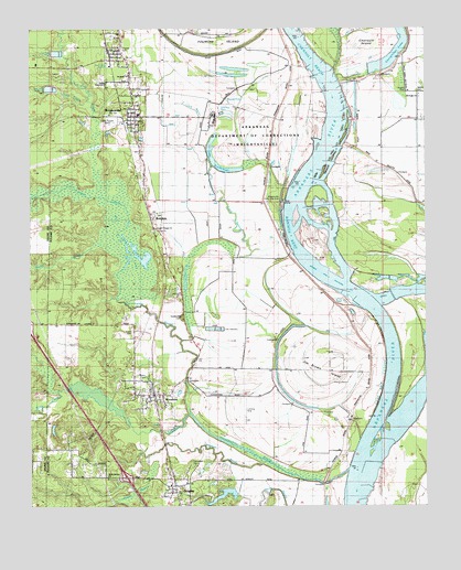
Woodson, AR USGS Topographic Map
Click on map above to begin viewing in our Map Viewer.

This topographic map contains these locations and features:
Feature Name Type Latitude Longitude GNIS ID View Map
Arkansas Boys State Industrial SchoolSchoolN34.6006°W92.1932°45918View Map
Arkansas Department of Corrections - WrightsvilleLocaleN34.5987°W92.1807°68082View Map
Arkansas Department of Corrections Wrightsville UnitBuildingN34.6075°W92.1922°2733395View Map
Big LakeLakeN34.5648°W92.2155°76339View Map
Birden CemeteryCemeteryN34.5340°W92.2132°46633View Map
Brown CemeteryCemeteryN34.5451°W92.2176°46994View Map
Camp CemeteriesCemeteryN34.5109°W92.1993°47310View Map
Campbell BayouStreamN34.5126°W92.1774°47342View Map
Cane CreekStreamN34.6056°W92.2318°47377View Map
Cephus ChurchChurchN34.6076°W92.2174°47665View Map
Chenault IslandIslandN34.6209°W92.1446°56657View Map
Chenault ReachChannelN34.6168°W92.1613°56658View Map
City of WrightsvilleCivilN34.6058°W92.2104°2405794View Map
Clark BayouStreamN34.5673°W92.1863°76619View Map
Clear CreekStreamN34.5243°W92.1996°47830View Map
Dickey (historical)Populated PlaceN34.6015°W92.1324°75606View Map
Dickey CemeteryCemeteryN34.6081°W92.1304°48507View Map
Ferguson LakeLakeN34.5290°W92.2300°78953View Map
Fish CreekStreamN34.5898°W92.2299°49061View Map
Georgetown LakeLakeN34.6158°W92.1376°77008View Map
Gospel Temple ChurchChurchN34.5726°W92.2099°49522View Map
Harris BendBendN34.5023°W92.1474°2784715View Map
HensleyPopulated PlaceN34.5054°W92.2057°77164View Map
Hensley Census Designated PlaceCensusN34.5069°W92.2069°2402578View Map
Hensley Fire Department Station 1BuildingN34.5043°W92.2064°2116555View Map
Hensley Fire Department Station 2BuildingN34.5084°W92.2268°2116556View Map
Hensley Post OfficePost OfficeN34.5034°W92.2051°84421View Map
Highway 365 Volunteer Fire Department Station 2BuildingN34.5979°W92.2163°2116573View Map
Jackson Memorial ChurchChurchN34.6112°W92.2260°56656View Map
Jim Brown IslandIslandN34.5368°W92.1604°77377View Map
KAAY-AM (Little Rock)TowerN34.6001°W92.2251°85316View Map
Kuykendall BrakeSwampN34.5690°W92.1936°50918View Map
Kuykendall CemeteryCemeteryN34.5498°W92.2021°50919View Map
Lake KuykendallLakeN34.5881°W92.1883°77277View Map
Lake Kuykendall DamDamN34.5904°W92.1918°79550View Map
Little Rock Gillett LeveeLeveeN34.5870°W92.1335°51321View Map
Lorance CreekStreamN34.5723°W92.2218°77554View Map
Maple CreekStreamN34.5687°W92.2285°51654View Map
Miller CreekStreamN34.5306°W92.2407°77664View Map
Nelson CemeteryCemeteryN34.6087°W92.1276°52604View Map
New Eagle ChurchChurchN34.6154°W92.1332°52637View Map
Old Eagle ChurchChurchN34.6070°W92.1271°68438View Map
Pennington BayouStreamN34.5098°W92.1496°53272View Map
RottakenPopulated PlaceN34.5731°W92.2110°54228View Map
Round HoleLakeN34.6066°W92.1878°77308View Map
TaftonPopulated PlaceN34.6195°W92.2213°58726View Map
Tango 7 AirportAirportN34.5226°W92.1677°2717284View Map
Township of Campbell (historical)CivilN34.6237°W92.2043°68130View Map
Township of Perkins (historical)CivilN34.5390°W92.2001°68459View Map
Virginia ChurchChurchN34.6201°W92.2218°55926View Map
Waldron LakeReservoirN34.5387°W92.2252°79552View Map
Waldron Lake DamDamN34.5384°W92.2251°79551View Map
Walton LakeReservoirN34.5981°W92.2254°79549View Map
Walton Lake DamDamN34.5984°W92.2251°79548View Map
Warings BendBendN34.5708°W92.1679°2784714View Map
West Hensley ChurchChurchN34.5079°W92.2265°56659View Map
WoodsonPopulated PlaceN34.5293°W92.2110°56536View Map
Woodson Census Designated PlaceCensusN34.5381°W92.2211°2403042View Map
WrightsvillePopulated PlaceN34.6023°W92.2168°56563View Map
Wrightsville Post OfficePost OfficeN34.6015°W92.2171°84428View Map
Wrightsville Public Use AreaParkN34.5793°W92.1713°56564View Map

Note: Coordinates in the location and feature list above are referenced to NAD83 datum.


Copyright (C) 2008-2025 Ryan Niemi / Sunset Dynamics ... All Rights Reserved