TopoQuest Logo
Do you find TopoQuest useful?
Help keep TopoQuest running and adding new maps/features by donating!
Bitcoin:  19c7KJd3qBynnjoSw5npx9KScwjBe4ifkT
Litecoin:  LXs6TkuXGGXo1vDsWCkWVdjQX94eUKd6ui
Home View Maps Find Maps Find Places Resources & Links


Rena Lara, Mississippi Topographic Map

USGS Map Title: Rena Lara, MS
USGS Map MRC: 34090B7
DRG (GeoTIFF) Download: o34090b7.tif


Neighboring USGS Topographic Map Quads:


  Lambrook, AR  
34090C8
 

  Elaine, AR  
34090C7
 

  Friars Point, MS  
34090C6
 

  Mellwood, AR  
34090B8
 

  Rena Lara, MS  
34090B7
 

  Sherard, MS  
34090B6
 

  Laconia, AR  
34090A8
 

  Round Lake, MS  
34090A7
 

  Duncan, MS  
34090A6


Map MRC Location:

N35°
W91°
N35°
W90°
H8 H7 H6 H5 H4 H3 H2 H1
G8 G7 G6 G5 G4 G3 G2 G1
F8 F7 F6 F5 F4 F3 F2 F1
E8 E7 E6 E5 E4 E3 E2 E1
D8 D7 D6 D5 D4 D3 D2 D1
C8 C7 C6 C5 C4 C3 C2 C1
B8 B7 B6 B5 B4 B3 B2 B1
A8 A7 A6 A5 A4 A3 A2 A1
N34°
W91°
N34°
W90°

Rena Lara, MS USGS 1:24K Topographic Map Preview:
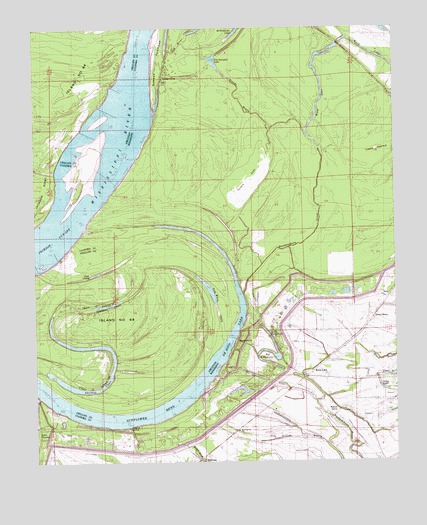
Rena Lara, MS USGS Topographic Map
Click on map above to begin viewing in our Map Viewer.

This topographic map contains these locations and features:
Feature Name Type Latitude Longitude GNIS ID View Map
Anderson LandingPopulated PlaceN34.1398°W90.8668°691666View Map
Big Eddy LakeLakeN34.1534°W90.7938°689214View Map
Blands BayouStreamN34.2204°W90.7809°689217View Map
Bough School (historical)SchoolN34.1357°W90.8034°689220View Map
Chute of IslandGutN34.1701°W90.8632°47784View Map
Clear LakeLakeN34.1498°W90.7515°668583View Map
Coahoma County Volunteer Fire Department Rena LaraBuildingN34.1539°W90.7750°2665932View Map
Desoto LakeLakeN34.1374°W90.8519°65615View Map
Desoto LandingLocaleN34.1601°W90.8051°689253View Map
Gold Dust Plantation (historical)LocaleN34.1418°W90.7932°710437View Map
Grants Landing (historical)LocaleN34.1534°W90.8090°689268View Map
Green GrovePopulated PlaceN34.1629°W90.7609°691906View Map
HillhousePopulated PlaceN34.1257°W90.8182°671223View Map
Hillhouse LandingPopulated PlaceN34.1337°W90.8412°692038View Map
Hushpuckena CreekStreamN34.1734°W90.8026°671640View Map
Island Number 64IslandN34.2345°W90.8693°82457View Map
Island Number 66IslandN34.1632°W90.8368°82458View Map
Jackson Cut-OffChannelN34.1937°W90.8637°671780View Map
Jackson Island BarBarN34.2115°W90.8571°689283View Map
Jim Samples LakeLakeN34.2401°W90.8121°689285View Map
Lake Charles LandingPopulated PlaceN34.1429°W90.8726°691992View Map
Lewis SwampSwampN34.2147°W90.7554°672431View Map
Little Eddy LakeLakeN34.1626°W90.7953°689291View Map
Long LakeLakeN34.1459°W90.7546°672839View Map
Morning Star ChurchChurchN34.1334°W90.8051°673844View Map
Pushmataha LandingPopulated PlaceN34.1368°W90.8601°692162View Map
Rena LaraPopulated PlaceN34.1498°W90.7804°676600View Map
Rena Lara Post OfficePost OfficeN34.1498°W90.7813°2768730View Map
Renalara School (historical)SchoolN34.1401°W90.7637°689335View Map
Rescue LandingPopulated PlaceN34.2362°W90.8293°692170View Map
Rescue Landing RevetmentLeveeN34.1959°W90.8546°676605View Map
Robertsville (historical)Populated PlaceN34.2468°W90.7840°689337View Map
Robinsonville LandingLocaleN34.1440°W90.8184°689338View Map
Rosewood Plantation (historical)LocaleN34.1265°W90.8112°710446View Map
Square LakeSwampN34.2043°W90.8001°678195View Map
Sunflower BendBendN34.1448°W90.8237°55334View Map
Sunflower LandingPopulated PlaceN34.1662°W90.8020°692250View Map
Sunflower RevetmentLeveeN34.1543°W90.8098°678417View Map
Swan Lake (historical)LakeN34.2232°W90.8237°689363View Map
Walnut GrovePopulated PlaceN34.1404°W90.7695°679300View Map
Ward LakeLakeN34.2426°W90.7579°679335View Map
WillisPopulated PlaceN34.1404°W90.7945°689377View Map

Note: Coordinates in the location and feature list above are referenced to NAD83 datum.


Copyright (C) 2008-2025 Ryan Niemi / Sunset Dynamics ... All Rights Reserved