TopoQuest Logo
Do you find TopoQuest useful?
Help keep TopoQuest running and adding new maps/features by donating!
Bitcoin:  19c7KJd3qBynnjoSw5npx9KScwjBe4ifkT
Litecoin:  LXs6TkuXGGXo1vDsWCkWVdjQX94eUKd6ui
Home View Maps Find Maps Find Places Resources & Links


Mellwood, Arkansas Topographic Map

USGS Map Title: Mellwood, AR
USGS Map MRC: 34090B8
DRG (GeoTIFF) Download: o34090b8.tif


Neighboring USGS Topographic Map Quads:


  Indian Bay SE, AR  
34091C1
 

  Lambrook, AR  
34090C8
 

  Elaine, AR  
34090C7
 

  Henrico NE, AR  
34091B1
 

  Mellwood, AR  
34090B8
 

  Rena Lara, MS  
34090B7
 

  Snow Lake, AR  
34091A1
 

  Laconia, AR  
34090A8
 

  Round Lake, MS  
34090A7


Map MRC Location:

N35°
W91°
N35°
W90°
H8 H7 H6 H5 H4 H3 H2 H1
G8 G7 G6 G5 G4 G3 G2 G1
F8 F7 F6 F5 F4 F3 F2 F1
E8 E7 E6 E5 E4 E3 E2 E1
D8 D7 D6 D5 D4 D3 D2 D1
C8 C7 C6 C5 C4 C3 C2 C1
B8 B7 B6 B5 B4 B3 B2 B1
A8 A7 A6 A5 A4 A3 A2 A1
N34°
W91°
N34°
W90°

Mellwood, AR USGS 1:24K Topographic Map Preview:
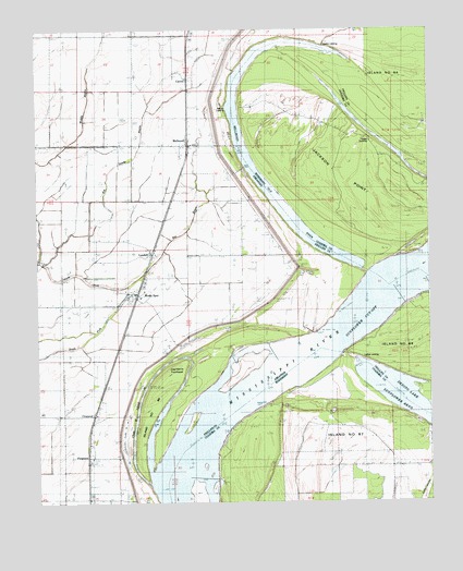
Mellwood, AR USGS Topographic Map
Click on map above to begin viewing in our Map Viewer.

This topographic map contains these locations and features:
Feature Name Type Latitude Longitude GNIS ID View Map
Avenue LandingLocaleN34.2290°W90.9396°65600View Map
Avenue RevetmentLeveeN34.2090°W90.9293°45986View Map
Bee BayouStreamN34.1820°W90.9712°46289View Map
Below Ludlow DikesLeveeN34.1648°W90.9251°70110View Map
Big Sandy BayouStreamN34.1882°W90.9979°46592View Map
Brown ChapelChurchN34.1468°W90.9823°47003View Map
CatronPopulated PlaceN34.2373°W90.9518°76548View Map
Chute of Island 68LakeN34.1448°W90.9635°47785View Map
CrumrodPopulated PlaceN34.1487°W90.9818°57615View Map
Crumrod Post OfficePost OfficeN34.1398°W90.9837°84331View Map
Dawson LandingLocaleN34.2457°W90.9076°65613View Map
FergusonPopulated PlaceN34.1382°W90.9840°57748View Map
Ferguson LandingPopulated PlaceN34.1276°W90.9640°57014View Map
Griffin Ag AirportAirportN34.1978°W90.9526°2650735View Map
Island Number 68IslandN34.1507°W90.9643°82459View Map
Island Number SixtyfiveIslandN34.2345°W90.9212°671734View Map
Island Number SixtysevenIslandN34.1345°W90.9326°671735View Map
Island Sixtyseven RevetmentLeveeN34.1454°W90.9379°671727View Map
Jackson PointCliffN34.2220°W90.8973°671786View Map
Jug Harris TowheadIslandN34.1618°W90.9546°50757View Map
Lodlow RevetmentLeveeN34.1737°W90.9046°51383View Map
Ludlow LandingLocaleN34.1629°W90.8959°65636View Map
Ludlow RevetmentLeveeN34.1759°W90.9037°70117View Map
LundellPopulated PlaceN34.1920°W90.9623°58102View Map
MellwoodPopulated PlaceN34.2198°W90.9504°58161View Map
Mellwood Post OfficePost OfficeN34.2197°W90.9510°84333View Map
Mellwood School (historical)SchoolN34.2193°W90.9493°70118View Map
Mosby SpurPopulated PlaceN34.1795°W90.9673°77697View Map
Mosby Spur School (historical)SchoolN34.1734°W90.9707°70122View Map
New Hope (historical)Populated PlaceN34.1829°W90.9218°70125View Map
Offutt LandingPopulated PlaceN34.1884°W90.9026°58296View Map
Precious ChapelChurchN34.1434°W90.9832°53782View Map
Reese LandingPopulated PlaceN34.2193°W90.8879°692168View Map
South Phillips County Volunteer Fire Department Station 2BuildingN34.2210°W90.9511°2117145View Map
South Phillips County Volunteer Fire Station 1BuildingN34.1806°W90.9683°2117146View Map
Sunflower Cut-OffBendN34.1754°W90.8940°78500View Map
Swan LakeLakeN34.1337°W90.9053°678450View Map
Township of MooneyCivilN34.1921°W90.9708°78865View Map
True Light ChurchChurchN34.2187°W90.9707°55667View Map
Zion Traveler CemeteryLocaleN34.1979°W90.9518°56653View Map
Zion Traveler ChurchChurchN34.2176°W90.9498°56654View Map

Note: Coordinates in the location and feature list above are referenced to NAD83 datum.


Copyright (C) 2008-2024 Ryan Niemi / Sunset Dynamics ... All Rights Reserved