TopoQuest Logo
Do you find TopoQuest useful?
Help keep TopoQuest running and adding new maps/features by donating!
Bitcoin:  19c7KJd3qBynnjoSw5npx9KScwjBe4ifkT
Litecoin:  LXs6TkuXGGXo1vDsWCkWVdjQX94eUKd6ui
Home View Maps Find Maps Find Places Resources & Links


Requa, California Topographic Map

USGS Map Title: Requa, CA
USGS Map MRC: 41124E1
DRG (GeoTIFF) Download: o41124e1.tif


Neighboring USGS Topographic Map Quads:


  Sister Rocks, CA  
41124F2
 

  Childs Hill, CA  
41124F1
 

  Canthook Mountain, CA  
41123F8


  Requa, CA  
41124E1
 

  Klamath Glen, CA  
41123E8


  Fern Canyon, CA  
41124D1
 

  Ah Pah Ridge, CA  
41123D8


Map MRC Location:

N42°
W125°
N42°
W124°
H8 H7 H6 H5 H4 H3 H2 H1
G8 G7 G6 G5 G4 G3 G2 G1
F8 F7 F6 F5 F4 F3 F2 F1
E8 E7 E6 E5 E4 E3 E2 E1
D8 D7 D6 D5 D4 D3 D2 D1
C8 C7 C6 C5 C4 C3 C2 C1
B8 B7 B6 B5 B4 B3 B2 B1
A8 A7 A6 A5 A4 A3 A2 A1
N41°
W125°
N41°
W124°

Requa, CA USGS 1:24K Topographic Map Preview:
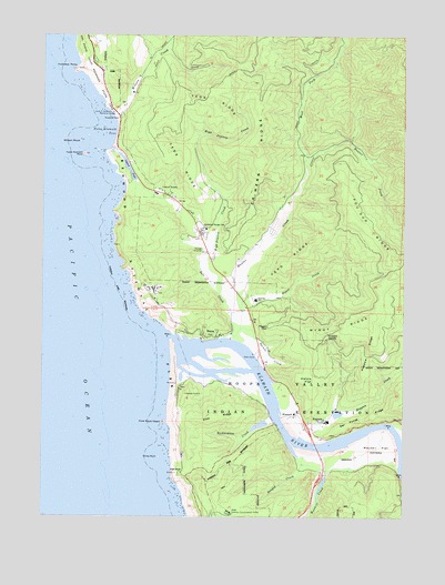
Requa, CA USGS Topographic Map
Click on map above to begin viewing in our Map Viewer.

This topographic map contains these locations and features:
Feature Name Type Latitude Longitude GNIS ID View Map
Alder Forestry Conservation CampLocaleN41.5007°W124.0609°256166View Map
Camp KlamathPopulated PlaceN41.5404°W124.0498°1657315View Map
Del Norte County Landing Strip (historical)AirportN41.5151°W124.0129°277107View Map
Del Ponte RidgeRidgeN41.5290°W124.0020°259261View Map
Douglas Memorial Bridge (historical)BridgeN41.5243°W124.0440°1657320View Map
Er-Wern RidgeRidgeN41.6126°W124.0537°259951View Map
False KlamathPopulated PlaceN41.5918°W124.0954°254349View Map
False Klamath CoveBayN41.6001°W124.1017°260043View Map
False Klamath RockIslandN41.5943°W124.1117°260044View Map
Flint RidgeRidgeN41.5253°W124.0670°260207View Map
Flint Rock HeadSummitN41.5246°W124.0842°260208View Map
Footsteps RocksSummitN41.6161°W124.1149°1658556View Map
Hatzis FlatFlatN41.5346°W124.0331°261154View Map
High BluffCliffN41.5118°W124.0809°261314View Map
High Prairie CreekStreamN41.5679°W124.0720°261331View Map
HoppawPopulated PlaceN41.5243°W124.0301°1658779View Map
Hoppaw CreekStreamN41.5240°W124.0426°261462View Map
Hoppaw RidgeRidgeN41.5490°W124.0124°261463View Map
Hoppaw SaddleGapN41.5476°W124.0276°261464View Map
Hunter CreekStreamN41.5490°W124.0579°261639View Map
Khwunrghunme (historical)Populated PlaceN41.5346°W124.0776°1682084View Map
KlamathPopulated PlaceN41.5265°W124.0384°277534View Map
Klamath Air Force Station (historical)MilitaryN41.5589°W124.0878°2086561View Map
Klamath Census Designated PlaceCensusN41.5322°W124.0064°2408492View Map
Klamath DivisionCivilN41.5926°W124.0723°1935154View Map
Klamath Fire Protection District Station 34BuildingN41.5733°W124.0713°2622063View Map
Klamath Fire Protection District Station 35BuildingN41.5754°W124.0461°2622295View Map
Klamath Post OfficePost OfficeN41.5319°W124.0412°2760039View Map
Klamath RiverStreamN41.5331°W124.0811°266887View Map
Lagoon Creek Fishing AccessLocaleN41.5954°W124.1009°1702438View Map
Lagoon PondLakeN41.5924°W124.0989°252554View Map
Louis P DeMartin Senior Memorial BridgeBridgeN41.6051°W124.1012°262970View Map
Margaret Keating Elementary SchoolSchoolN41.5561°W124.0528°262088View Map
Mynot CreekStreamN41.5532°W124.0570°263995View Map
Mynot RidgeRidgeN41.5508°W124.0147°263996View Map
Pisgah ViewLocaleN41.5493°W124.0484°264814View Map
Pou-Oup RidgeRidgeN41.5690°W124.0060°265011View Map
Redwood Ranger StationLocaleN41.5760°W124.0709°265354View Map
Rekwoi (historical)Populated PlaceN41.5415°W124.0512°1682089View Map
RequaPopulated PlaceN41.5468°W124.0665°1659500View Map
Requa School (historical)SchoolN41.5540°W124.0554°1657341View Map
Resighini RancheriaCivilN41.5145°W124.0166°1657342View Map
Richardson CreekStreamN41.5246°W124.0459°265407View Map
Safford Island (historical)IslandN41.5368°W124.0512°1657344View Map
Salt CreekStreamN41.5462°W124.0629°265766View Map
Saugep CreekStreamN41.5157°W124.0373°265856View Map
Spruce CreekStreamN41.5476°W124.0606°267613View Map
Teds RidgeRidgeN41.6071°W124.0674°268119View Map
Tepo RidgeRidgeN41.5717°W124.0333°268154View Map
Trees of MysteryWoodsN41.5851°W124.0854°268394View Map
Turwar CreekStreamN41.5204°W124.0017°268505View Map
Waukell CreekStreamN41.5135°W124.0362°268819View Map
Waukell FlatFlatN41.5182°W124.0092°268820View Map
Waukell Flat (historical)Populated PlaceN41.5176°W124.0170°1657352View Map
West Fork Hunter CreekStreamN41.5926°W124.0359°268904View Map
White RockIslandN41.5151°W124.0856°269015View Map
Wilson CreekStreamN41.6046°W124.1017°269202View Map
Wilson Creek BeachBeachN41.6021°W124.1004°1702444View Map
Wilson RockIslandN41.5976°W124.1134°269215View Map
Yurok Redwood Experimental ForestForestN41.5923°W124.0640°277106View Map

Note: Coordinates in the location and feature list above are referenced to NAD83 datum.


Copyright (C) 2008-2025 Ryan Niemi / Sunset Dynamics ... All Rights Reserved