TopoQuest Logo
Do you find TopoQuest useful?
Help keep TopoQuest running and adding new maps/features by donating!
Bitcoin:  19c7KJd3qBynnjoSw5npx9KScwjBe4ifkT
Litecoin:  LXs6TkuXGGXo1vDsWCkWVdjQX94eUKd6ui
Home View Maps Find Maps Find Places Resources & Links


Richmond Dale, Ohio Topographic Map

USGS Map Title: Richmond Dale, OH
USGS Map MRC: 39082B7
DRG (GeoTIFF) Download: o39082b7.tif


Neighboring USGS Topographic Map Quads:


  Chillicothe East, OH  
39082C8
 

  Londonderry, OH  
39082C7
 

  Ratcliffburg, OH  
39082C6
 

  Waverly North, OH  
39082B8
 

  Richmond Dale, OH  
39082B7
 

  Byer, OH  
39082B6
 

  Waverly South, OH  
39082A8
 

  Beaver, OH  
39082A7
 

  Jackson, OH  
39082A6


Map MRC Location:

N40°
W83°
N40°
W82°
H8 H7 H6 H5 H4 H3 H2 H1
G8 G7 G6 G5 G4 G3 G2 G1
F8 F7 F6 F5 F4 F3 F2 F1
E8 E7 E6 E5 E4 E3 E2 E1
D8 D7 D6 D5 D4 D3 D2 D1
C8 C7 C6 C5 C4 C3 C2 C1
B8 B7 B6 B5 B4 B3 B2 B1
A8 A7 A6 A5 A4 A3 A2 A1
N39°
W83°
N39°
W82°

Richmond Dale, OH USGS 1:24K Topographic Map Preview:
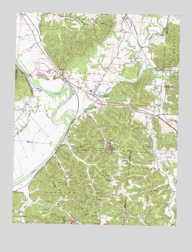
Richmond Dale, OH USGS Topographic Map
Click on map above to begin viewing in our Map Viewer.

This topographic map contains these locations and features:
Feature Name Type Latitude Longitude GNIS ID View Map
Beals CemeteryCemeteryN39.2081°W82.8244°1037709View Map
Bethel Carr ChurchChurchN39.1456°W82.7682°1060864View Map
Brocke Corner CemeteryCemeteryN39.1909°W82.7618°1964018View Map
Brocks CornerPopulated PlaceN39.1906°W82.7604°1070693View Map
Buzzard RockCliffN39.1715°W82.7707°1038583View Map
Caldwell CemeteryCemeteryN39.2217°W82.8505°1038611View Map
Canada (historical)Populated PlaceN39.2387°W82.8438°1050042View Map
Chimney RocksSummitN39.1690°W82.8243°1066644View Map
East Jackson SchoolSchoolN39.1290°W82.8685°1040003View Map
Elliot CemeteryCemeteryN39.2159°W82.7979°1040138View Map
German Chapel CemeteryCemeteryN39.1540°W82.7993°1040833View Map
Gillums LakeLakeN39.1963°W82.7628°1040867View Map
Goose CreekStreamN39.2337°W82.7763°1040962View Map
Grandview CemeteryCemeteryN39.1370°W82.8466°1041029View Map
Harris CemeteryCemeteryN39.1331°W82.8524°1041356View Map
Hay HollowValleyN39.1356°W82.8605°1041416View Map
Hay Hollow ChurchChurchN39.1376°W82.8463°1041417View Map
Hay Hollow ReservoirReservoirN39.1258°W82.8234°1077960View Map
Hay Hollow Reservoir DamDamN39.1267°W82.8266°1077959View Map
Haynes CemeteryCemeteryN39.1315°W82.8674°1041425View Map
Hickman CemeteryCemeteryN39.1659°W82.7554°1041519View Map
Hickson RunStreamN39.1717°W82.8396°1063460View Map
HigbyPopulated PlaceN39.1962°W82.8663°1064834View Map
Higby Elementary SchoolSchoolN39.1912°W82.8680°1050041View Map
Higby Post Office (historical)Post OfficeN39.1959°W82.8666°2056649View Map
Jackson RunStreamN39.1256°W82.8674°1042038View Map
Jackson Township Fire DepartmentBuildingN39.1296°W82.8688°2550456View Map
Jefferson Township Fire and RescueBuildingN39.2023°W82.8147°2549641View Map
Lick RunStreamN39.2365°W82.8560°1042535View Map
LimerickPopulated PlaceN39.1256°W82.7502°1064998View Map
Limerick Post Office (historical)Post OfficeN39.1256°W82.7513°2013738View Map
Little Mound CemeteryCemeteryN39.2092°W82.8102°1042674View Map
Middle Fork Salt CreekStreamN39.2145°W82.7660°1063456View Map
Mount SinaiPopulated PlaceN39.1426°W82.7985°1065076View Map
Mount Sinai CemeteryCemeteryN39.1412°W82.8004°1963415View Map
Mulgee CreekStreamN39.2273°W82.7810°1070860View Map
Mutton RunStreamN39.1653°W82.8449°1043751View Map
Pigeon CreekStreamN39.1673°W82.7652°1066893View Map
Pleasant Hill ChurchChurchN39.1515°W82.7988°1044552View Map
Pleasant Valley ChurchChurchN39.1745°W82.8043°1044596View Map
Reorganized Church of Jesus Christ of Latter Day SaintsChurchN39.1256°W82.7507°1071623View Map
Richmond DalePopulated PlaceN39.2020°W82.8138°1085483View Map
Richmond Dale Census Designated PlaceCensusN39.2042°W82.8121°2628958View Map
Richmond Dale Post OfficePost OfficeN39.2015°W82.8138°2043404View Map
Richmondale Elementary SchoolSchoolN39.2048°W82.8166°1050045View Map
RittenoursPopulated PlaceN39.2165°W82.8427°1062979View Map
Rupel School (historical)SchoolN39.2431°W82.8346°1050043View Map
Salt CreekStreamN39.1917°W82.8324°1045907View Map
Salt Lick CreekStreamN39.2140°W82.7663°1076278View Map
Sandy Bottom CreekStreamN39.1873°W82.8471°1045952View Map
Sigler CemeteryCemeteryN39.1942°W82.7760°1046265View Map
Southeastern High SchoolSchoolN39.2042°W82.8174°1050044View Map
Southern Silica Pond Number OneReservoirN39.1736°W82.7996°1078953View Map
Southern Silica Pond Number One DamDamN39.1734°W82.8016°1078952View Map
Southern Silica Pond Number TwoReservoirN39.1728°W82.7958°1078955View Map
Southern Silica Pond Number Two DamDamN39.1734°W82.7966°1078954View Map
Stockman CemeteryCemeteryN39.1942°W82.8108°1046705View Map
Sycamore HollowValleyN39.1887°W82.7577°1046921View Map
Township of JacksonCivilN39.1328°W82.8708°1086810View Map
Township of JeffersonCivilN39.2102°W82.8140°1086899View Map
Tweed CemeteryCemeteryN39.2396°W82.7940°1047239View Map
VigoPopulated PlaceN39.2478°W82.7929°1065438View Map
Vigo Post Office (historical)Post OfficeN39.2473°W82.7929°2056679View Map
Walnut CreekStreamN39.2217°W82.8743°1047528View Map
Weddington CemeteryCemeteryN39.1495°W82.8416°1047654View Map
Weddington HillSummitN39.1465°W82.8380°1047655View Map
West JunctionPopulated PlaceN39.2181°W82.7682°1063086View Map
Whisky RunStreamN39.1917°W82.8260°1047866View Map
Zion Church (historical)ChurchN39.1253°W82.7688°1049593View Map

Note: Coordinates in the location and feature list above are referenced to NAD83 datum.


Copyright (C) 2008-2025 Ryan Niemi / Sunset Dynamics ... All Rights Reserved