TopoQuest Logo
Do you find TopoQuest useful?
Help keep TopoQuest running and adding new maps/features by donating!
Bitcoin:  19c7KJd3qBynnjoSw5npx9KScwjBe4ifkT
Litecoin:  LXs6TkuXGGXo1vDsWCkWVdjQX94eUKd6ui
Home View Maps Find Maps Find Places Resources & Links


Beaver, Ohio Topographic Map

USGS Map Title: Beaver, OH
USGS Map MRC: 39082A7
DRG (GeoTIFF) Download: o39082a7.tif


Neighboring USGS Topographic Map Quads:


  Waverly North, OH  
39082B8
 

  Richmond Dale, OH  
39082B7
 

  Byer, OH  
39082B6
 

  Waverly South, OH  
39082A8
 

  Beaver, OH  
39082A7
 

  Jackson, OH  
39082A6
 

  Lucasville, OH  
38082H8
 

  Stockdale, OH  
38082H7
 

  Petersburg, OH  
38082H6


Map MRC Location:

N40°
W83°
N40°
W82°
H8 H7 H6 H5 H4 H3 H2 H1
G8 G7 G6 G5 G4 G3 G2 G1
F8 F7 F6 F5 F4 F3 F2 F1
E8 E7 E6 E5 E4 E3 E2 E1
D8 D7 D6 D5 D4 D3 D2 D1
C8 C7 C6 C5 C4 C3 C2 C1
B8 B7 B6 B5 B4 B3 B2 B1
A8 A7 A6 A5 A4 A3 A2 A1
N39°
W83°
N39°
W82°

Beaver, OH USGS 1:24K Topographic Map Preview:
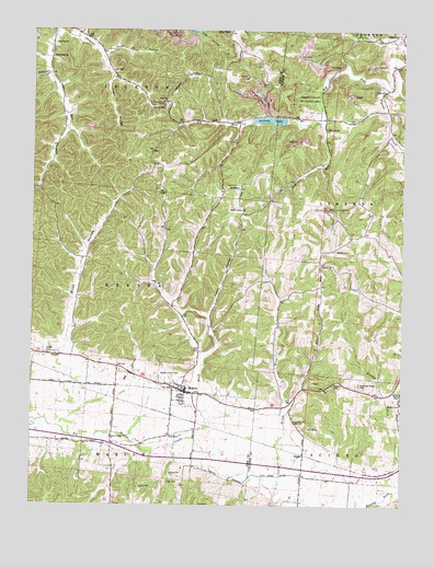
Beaver, OH USGS Topographic Map
Click on map above to begin viewing in our Map Viewer.

This topographic map contains these locations and features:
Feature Name Type Latitude Longitude GNIS ID View Map
Allen ChapelChurchN39.1245°W82.8091°1037369View Map
Allen Chapel CemeteryCemeteryN39.1240°W82.8088°1963392View Map
Barton CemeteryCemeteryN39.1045°W82.8307°1037659View Map
BeaverPopulated PlaceN39.0306°W82.8243°1064399View Map
Beaver Elementary SchoolSchoolN39.0306°W82.8229°1055165View Map
Beaver Post OfficePost OfficeN39.0306°W82.8249°2042468View Map
Beaver Sewage Treatment PlantLocaleN39.0319°W82.8203°2678277View Map
Beaver Union CemeteryCemeteryN39.0340°W82.8316°1037768View Map
Beaver Valley ChurchChurchN39.0184°W82.8474°1037769View Map
Beaver Volunteer Fire DepartmentBuildingN39.0281°W82.8265°2550129View Map
Bee LickStreamN39.1131°W82.8702°1055166View Map
Bethel CemeteryCemeteryN39.0673°W82.7724°1037902View Map
Bethel ChurchChurchN39.0631°W82.7771°1037924View Map
Big RockSummitN39.0995°W82.7754°1048523View Map
Big RockPopulated PlaceN39.1017°W82.7763°1049577View Map
Big Rock LakeReservoirN39.1015°W82.7952°1078509View Map
Big Rock Lake DamDamN39.1001°W82.7899°1078508View Map
Big RunStreamN39.1095°W82.7571°1038018View Map
Buck HollowValleyN39.0423°W82.8627°1038457View Map
Buck Hollow Church (historical)ChurchN39.0645°W82.8566°1055171View Map
Carrs Run CemeteryCemeteryN39.1212°W82.8704°1963398View Map
Carrs Run ChurchChurchN39.1215°W82.8682°1038841View Map
Cars Run (historical)Populated PlaceN39.0959°W82.8666°1067177View Map
Cars Run Post Office (historical)Post OfficeN39.0959°W82.8674°2042455View Map
Cars Run School (historical)SchoolN39.0956°W82.8666°1055173View Map
Cordle CemeteryCemeteryN39.0398°W82.8691°1039369View Map
Dry RunStreamN39.1009°W82.7779°1039811View Map
Dutch HollowValleyN39.0506°W82.8143°1039900View Map
Eastburn (historical)Populated PlaceN39.1042°W82.7557°1071042View Map
Eastburn Post Office (historical)Post OfficeN39.1042°W82.7554°2013719View Map
Eastern High SchoolSchoolN39.0331°W82.8432°1055178View Map
Emmanuel United Methodist ChurchChurchN39.0320°W82.8266°1963400View Map
Estell HollowValleyN39.1192°W82.8505°1040236View Map
Funk CemeteryCemeteryN39.0059°W82.8252°1040729View Map
GladePopulated PlaceN39.0134°W82.7827°1064724View Map
Glade Airport (historical)AirportN39.0121°W82.7897°1082487View Map
Glade Post Office (historical)Post OfficeN39.0140°W82.7832°2013722View Map
Howells CrossingLocaleN39.0090°W82.7621°1049585View Map
Jackson CemeteryCemeteryN39.0842°W82.8052°1042021View Map
Jackson LakeLakeN39.1017°W82.7943°1042033View Map
Liberty Wildlife AreaParkN39.1070°W82.7816°1042525View Map
LinnPopulated PlaceN39.1012°W82.8141°1065712View Map
Linn Hill ChurchChurchN39.1059°W82.8305°1042604View Map
Linn Post Office (historical)Post OfficeN39.1015°W82.8138°2042466View Map
Mosher School (historical)SchoolN39.0184°W82.8477°1055201View Map
Mountain Ridge CemeteryCemeteryN39.0320°W82.7643°1964026View Map
New Cove School (historical)SchoolN39.0206°W82.7504°1049589View Map
New Zion ChurchChurchN39.0223°W82.7863°1043850View Map
Newman HollowValleyN39.1128°W82.8716°1043864View Map
Old German Number 2 CemeteryCemeteryN39.0326°W82.8265°1963421View Map
Philadelphia ChurchChurchN39.1173°W82.8688°1044414View Map
Poplar RunStreamN39.1231°W82.7516°1044697View Map
Radar School (historical)SchoolN39.0617°W82.8088°1055217View Map
Sugar HollowValleyN39.1120°W82.8491°1046814View Map
Swift CreekStreamN39.0187°W82.8188°1046903View Map
Township of BeaverCivilN39.0589°W82.8597°1086807View Map
Village of BeaverCivilN39.0319°W82.8253°2398059View Map

Note: Coordinates in the location and feature list above are referenced to NAD83 datum.


Copyright (C) 2008-2024 Ryan Niemi / Sunset Dynamics ... All Rights Reserved