TopoQuest Logo
Do you find TopoQuest useful?
Help keep TopoQuest running and adding new maps/features by donating!
Bitcoin:  19c7KJd3qBynnjoSw5npx9KScwjBe4ifkT
Litecoin:  LXs6TkuXGGXo1vDsWCkWVdjQX94eUKd6ui
Home View Maps Find Maps Find Places Resources & Links


Waverly South, Ohio Topographic Map

USGS Map Title: Waverly South, OH
USGS Map MRC: 39082A8
DRG (GeoTIFF) Download: o39082a8.tif


Neighboring USGS Topographic Map Quads:


  Summithill, OH  
39083B1
 

  Waverly North, OH  
39082B8
 

  Richmond Dale, OH  
39082B7
 

  Piketon, OH  
39083A1
 

  Waverly South, OH  
39082A8
 

  Beaver, OH  
39082A7
 

  Wakefield, OH  
38083H1
 

  Lucasville, OH  
38082H8
 

  Stockdale, OH  
38082H7


Map MRC Location:

N40°
W83°
N40°
W82°
H8 H7 H6 H5 H4 H3 H2 H1
G8 G7 G6 G5 G4 G3 G2 G1
F8 F7 F6 F5 F4 F3 F2 F1
E8 E7 E6 E5 E4 E3 E2 E1
D8 D7 D6 D5 D4 D3 D2 D1
C8 C7 C6 C5 C4 C3 C2 C1
B8 B7 B6 B5 B4 B3 B2 B1
A8 A7 A6 A5 A4 A3 A2 A1
N39°
W83°
N39°
W82°

Waverly South, OH USGS 1:24K Topographic Map Preview:
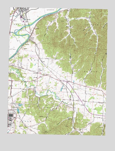
Waverly South, OH USGS Topographic Map
Click on map above to begin viewing in our Map Viewer.

This topographic map contains these locations and features:
Feature Name Type Latitude Longitude GNIS ID View Map
Atomic Energy Commission DamDamN39.0284°W82.9866°1077951View Map
Atomic Energy Commission LakeReservoirN39.0285°W82.9841°1077952View Map
Atomic Energy Commission PondReservoirN39.0228°W82.9866°1077954View Map
Atomic Energy Commission Pond DamDamN39.0201°W82.9866°1077953View Map
Bandy HollowValleyN39.1073°W82.8974°1037612View Map
Barger CemeteryCemeteryN39.0845°W82.9807°1037630View Map
Beaver ChapelChurchN39.0323°W82.8791°1037746View Map
Beaver Chapel CemeteryCemeteryN39.0323°W82.8793°1963395View Map
Beaver Pike EstatesPopulated PlaceN39.0492°W82.9083°2544739View Map
Blosser CemeteryCemeteryN39.0156°W82.9232°1038129View Map
BoboPopulated PlaceN39.0234°W82.9452°1062653View Map
Bobo Post Office (historical)Post OfficeN39.0237°W82.9457°2042452View Map
Browns School (historical)SchoolN39.1148°W82.8974°1055170View Map
Brust Number 2 CemeteryCemeteryN39.0590°W82.9557°1080051View Map
Chase CemeteryCemeteryN39.1123°W82.9302°1039006View Map
Daniels CemeteryCemeteryN39.0529°W82.9634°1039572View Map
Dapp CemeteryCemeteryN39.0931°W82.9724°1039575View Map
Dog HollowValleyN39.0451°W82.9166°1039732View Map
Downing CemeteryCemeteryN39.1045°W82.9666°1039775View Map
Dutch RunStreamN39.0070°W82.9166°1039904View Map
East Elementary SchoolSchoolN39.1242°W82.9796°1055177View Map
Enterprise ChurchChurchN39.1159°W82.8982°1040217View Map
Evergreen CemeteryCemeteryN39.1173°W82.9838°1040268View Map
Ferree Church (historical)ChurchN39.0265°W82.9882°1055180View Map
Ferree Gilead ChurchChurchN39.0476°W82.9982°1040427View Map
Fivemile CreekStreamN39.0453°W82.9166°1067081View Map
Fourmile CreekStreamN39.0312°W82.9243°1040620View Map
Fry School (historical)SchoolN39.0173°W82.8805°1055183View Map
GermanyPopulated PlaceN39.0028°W82.9055°1040826View Map
Germany CemeteryCemeteryN39.0042°W82.9068°1963403View Map
Germany Post Office (historical)Post OfficeN39.0028°W82.9060°2042459View Map
Given Post Office (historical)Post OfficeN39.0528°W82.9249°2043429View Map
GivensPopulated PlaceN39.0531°W82.9243°1064723View Map
Givens Chapel CemeteryCemeteryN39.0503°W82.9304°1963404View Map
Givens HollowValleyN39.0609°W82.9177°1040876View Map
Glen JeanPopulated PlaceN39.1128°W82.9774°1062784View Map
Green AcresPopulated PlaceN39.1226°W82.9885°1055186View Map
GreggsPopulated PlaceN39.0715°W82.9574°1064765View Map
Greggs HillPopulated PlaceN39.0945°W82.9730°1062794View Map
Greggs Hill CemeteryCemeteryN39.0892°W82.9791°1041178View Map
Hamman CemeteryCemeteryN39.0587°W82.9516°1963405View Map
Hamman ChurchChurchN39.0587°W82.9518°1041275View Map
Happy HollowValleyN39.0365°W82.9610°1041297View Map
Hawk CemeteryCemeteryN39.0038°W82.9772°1041403View Map
Holt CemeteryCemeteryN39.0417°W82.9790°1041685View Map
James CemeteryCemeteryN39.0229°W82.9440°1042048View Map
Jenkins HollowValleyN39.1051°W82.8963°1042078View Map
Lilly Chapel (historical)ChurchN39.1006°W82.8893°1055196View Map
Lucas CemeteryCemeteryN39.0626°W82.9697°1042819View Map
Marcus RunStreamN39.1203°W82.9421°1066825View Map
Meadow Run ChurchChurchN39.1070°W82.9224°1043196View Map
Meadow Run ChurchChurchN39.1231°W82.9266°1043197View Map
Miller School (historical)SchoolN39.0745°W82.9443°1055199View Map
Millers RunStreamN39.0323°W82.9318°1043378View Map
Millstone RunStreamN39.0165°W82.9149°1066839View Map
Moore School (historical)SchoolN39.0362°W82.9971°1055200View Map
Mount Carmel Church (historical)ChurchN39.0134°W82.9521°1055202View Map
Mount Gilead CemeteryCemeteryN39.0208°W82.9880°1043560View Map
Mount Gilead Church (historical)ChurchN39.0212°W82.9880°1055203View Map
Noland CemeteryCemeteryN39.0833°W82.9910°1043892View Map
Pecks CreekStreamN39.0298°W82.9143°1066887View Map
Pee Pee CreekStreamN39.0973°W82.9860°1066888View Map
Pennington CemeteryCemeteryN39.0078°W82.8781°1044369View Map
Pike Sanitation LandfillLocaleN39.0811°W82.9567°2635466View Map
Piketon SchoolSchoolN39.0562°W82.9638°1044445View Map
Pine KnobSummitN39.0176°W82.9596°1049084View Map
Pine LakeReservoirN39.0456°W82.9317°1077950View Map
Pine Lake DamDamN39.0434°W82.9332°1077949View Map
Red HollowValleyN39.0112°W82.8780°1044895View Map
RehmPopulated PlaceN39.0640°W82.9610°1057952View Map
Robbins (historical)Populated PlaceN39.0381°W82.8782°1071020View Map
Rock Spring School (historical)SchoolN39.0803°W82.9032°1055220View Map
Saint Marys Roman Catholic ChurchChurchN39.1237°W82.9813°1700881View Map
Sand HillSummitN39.0017°W82.9527°1065286View Map
Scratch HollowValleyN39.0476°W82.8849°1046072View Map
Shock CemeteryCemeteryN39.0458°W82.8927°1046230View Map
ShyvillePopulated PlaceN39.0076°W82.9857°1063017View Map
Shyville Post Office (historical)Post OfficeN39.0070°W82.9860°2044266View Map
Straight CreekStreamN39.1120°W82.9252°1046753View Map
Straight Creek CemeteryCemeteryN39.1167°W82.8982°1046754View Map
Township of SealCivilN39.0677°W82.9745°1086818View Map
Village of PiketonCivilN39.0649°W82.9985°2399673View Map
Waverly Fire DepartmentBuildingN39.1249°W82.9837°2550410View Map
Waverly Mobile Home ParkPopulated PlaceN39.1131°W82.9947°2652051View Map
Waverly PlacePopulated PlaceN39.1245°W82.9946°1055228View Map
Waverly Water Treatment PlantLocaleN39.1106°W82.9800°2740871View Map
Wheeler CemeteryCemeteryN39.0342°W82.9024°1047848View Map
Zahns CornersPopulated PlaceN39.0606°W82.9624°1079597View Map

Note: Coordinates in the location and feature list above are referenced to NAD83 datum.


Copyright (C) 2008-2024 Ryan Niemi / Sunset Dynamics ... All Rights Reserved