TopoQuest Logo
Do you find TopoQuest useful?
Help keep TopoQuest running and adding new maps/features by donating!
Bitcoin:  19c7KJd3qBynnjoSw5npx9KScwjBe4ifkT
Litecoin:  LXs6TkuXGGXo1vDsWCkWVdjQX94eUKd6ui
Home View Maps Find Maps Find Places Resources & Links


Ridgely, Tennessee Topographic Map

USGS Map Title: Ridgely, TN
USGS Map MRC: 36089C4
DRG (GeoTIFF) Download: o36089c4.tif


Neighboring USGS Topographic Map Quads:


  Point Pleasant, MO  
36089D5
 

  Tiptonville, TN  
36089D4
 

  Samburg, TN  
36089D3
 

  Mooring, TN  
36089C5
 

  Ridgely, TN  
36089C4
 

  Hornbeak, TN  
36089C3
 

  Tennemo, TN  
36089B5
 

  Miston, TN  
36089B4
 

  Lane, TN  
36089B3


Map MRC Location:

N37°
W90°
N37°
W89°
H8 H7 H6 H5 H4 H3 H2 H1
G8 G7 G6 G5 G4 G3 G2 G1
F8 F7 F6 F5 F4 F3 F2 F1
E8 E7 E6 E5 E4 E3 E2 E1
D8 D7 D6 D5 D4 D3 D2 D1
C8 C7 C6 C5 C4 C3 C2 C1
B8 B7 B6 B5 B4 B3 B2 B1
A8 A7 A6 A5 A4 A3 A2 A1
N36°
W90°
N36°
W89°

Ridgely, TN USGS 1:24K Topographic Map Preview:
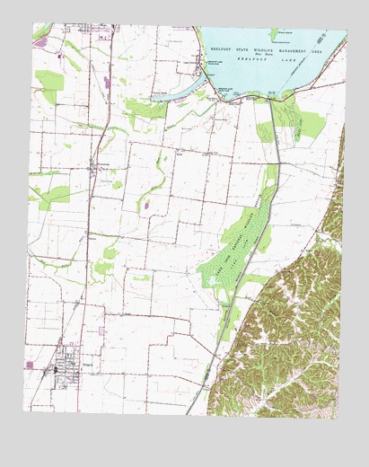
Ridgely, TN USGS Topographic Map
Click on map above to begin viewing in our Map Viewer.

This topographic map contains these locations and features:
Feature Name Type Latitude Longitude GNIS ID View Map
Agnes McCutchen ParkParkN36.2584°W89.4854°1319158View Map
Blue BankPopulated PlaceN36.3517°W89.4251°1305301View Map
Blue Bank BayouGutN36.3078°W89.4617°1277743View Map
Blue Bank LeveeLeveeN36.3556°W89.4279°1311389View Map
Blue BasinLakeN36.3667°W89.4081°1277745View Map
Box SloughGutN36.3531°W89.3954°1311818View Map
Broad SloughGutN36.3445°W89.3970°1311820View Map
Burrus CemeteryCemeteryN36.3420°W89.4362°1279123View Map
Campbells PointCapeN36.3576°W89.4281°1311390View Map
Carroll CreekStreamN36.3059°W89.3754°1279746View Map
Crocketts CemeteryCemeteryN36.3459°W89.4278°1319169View Map
Crocketts ChapelChurchN36.3456°W89.4279°1281651View Map
Cunningham CemeteryCemeteryN36.2678°W89.4206°1281870View Map
Davis Chapel (historical)ChurchN36.3684°W89.4467°1319171View Map
Davis Chapel CemeteryCemeteryN36.3703°W89.4467°1306283View Map
Edgewater BeachPopulated PlaceN36.3565°W89.4320°1311394View Map
Glory HoleBayN36.3601°W89.4284°1311396View Map
Gooch Reelfoot Airport (historical)AirportN36.3748°W89.4415°1301419View Map
GratioPopulated PlaceN36.2587°W89.4254°1285921View Map
Green Island PointCapeN36.3712°W89.4048°1286108View Map
Half Moon BasinBayN36.3734°W89.4126°1311400View Map
Harris DitchCanalN36.3562°W89.4737°1286980View Map
HaynesPopulated PlaceN36.3078°W89.4759°1287224View Map
KeefePopulated PlaceN36.3356°W89.4420°1289942View Map
Keefe CemeteryCemeteryN36.3345°W89.4406°1319180View Map
Keefe ChurchChurchN36.3348°W89.4412°1319181View Map
Keefe School (historical)SchoolN36.3353°W89.4415°1319183View Map
Kirks CampLocaleN36.3703°W89.3776°1320470View Map
Lake CountyCivilN36.3354°W89.4935°1639762View Map
Lake County Recreational ParkParkN36.3690°W89.4734°1319186View Map
Lake DrivePopulated PlaceN36.3631°W89.4337°1290483View Map
Lake IsomSwampN36.3020°W89.4156°1290492View Map
Lake Isom National Wildlife RefugeParkN36.3049°W89.4173°1290493View Map
Lara Kendall Elementary SchoolSchoolN36.2659°W89.4806°1319188View Map
Lids PocketBayN36.3523°W89.4220°1311410View Map
Long - Cunningham CemeteryCemeteryN36.2867°W89.4067°1291924View Map
Longs School (historical)SchoolN36.2731°W89.4109°1320472View Map
Lovells Boat DockLocaleN36.3581°W89.4292°1319189View Map
MadiePopulated PlaceN36.2817°W89.4615°1292481View Map
Madie CemeteryCemeteryN36.2820°W89.4617°1319190View Map
Madie Presbyterian ChurchChurchN36.2820°W89.4612°1319191View Map
Madie School (historical)SchoolN36.2823°W89.4617°1319192View Map
Magic HoleBayN36.3659°W89.4295°1311415View Map
Magnolia BeachPopulated PlaceN36.3515°W89.4404°1311416View Map
Middle LandingLocaleN36.3534°W89.4173°1315497View Map
New Haven CemeteryCemeteryN36.2762°W89.4698°1295488View Map
Owl CityPopulated PlaceN36.3345°W89.4295°1296587View Map
Pawpaw CreekStreamN36.3120°W89.4051°1297001View Map
PushLocaleN36.3037°W89.3904°1298715View Map
Reelfoot LakeLakeN36.3651°W89.4037°1299172View Map
Reelfoot Lake CampgroundsLocaleN36.3545°W89.3981°1320489View Map
Reelfoot Lake Outlet at SpillwayDamN36.3517°W89.4034°1302531View Map
Reelfoot Lake State ParkParkN36.3540°W89.4131°1299173View Map
Reelfoot Manor Nursing HomeBuildingN36.3706°W89.4729°1319205View Map
RidgelyPopulated PlaceN36.2634°W89.4879°1299402View Map
Ridgely CemeteryCemeteryN36.2623°W89.4698°1299403View Map
Ridgely City HallBuildingN36.2648°W89.4873°1319206View Map
Ridgely City Police DepartmentBuildingN36.2646°W89.4872°2765720View Map
Ridgely Division (historical)CensusN36.2645°W89.4870°1648812View Map
Ridgely Fire DepartmentBuildingN36.2645°W89.4872°2653721View Map
Ridgely Post OfficePost OfficeN36.2642°W89.4866°1651204View Map
Ridgely School (historical)SchoolN36.2712°W89.4862°1319207View Map
Rock BranchStreamN36.2881°W89.4176°1299729View Map
Shelby LakeSwampN36.3437°W89.3931°1269990View Map
Spain PointCapeN36.3731°W89.4067°1311428View Map
Sunkist BeachPopulated PlaceN36.3526°W89.4526°1303938View Map
Town of RidgelyCivilN36.2614°W89.4802°2407215View Map
Vanhorn CreekStreamN36.2537°W89.4045°1273377View Map
Webb ChapelPopulated PlaceN36.3273°W89.3779°1647546View Map
Webb ChapelChurchN36.3253°W89.3776°1274025View Map
WynnburgPopulated PlaceN36.3287°W89.4734°1275211View Map
Wynnburg Baptist ChurchChurchN36.3290°W89.4715°1319213View Map
Wynnburg Methodist ChurchChurchN36.3315°W89.4754°1319214View Map
Wynnburg Post OfficePost OfficeN36.3274°W89.4749°1651208View Map
Wynnburg School (historical)SchoolN36.3281°W89.4720°1319215View Map

Note: Coordinates in the location and feature list above are referenced to NAD83 datum.


Copyright (C) 2008-2025 Ryan Niemi / Sunset Dynamics ... All Rights Reserved