TopoQuest Logo
Do you find TopoQuest useful?
Help keep TopoQuest running and adding new maps/features by donating!
Bitcoin:  19c7KJd3qBynnjoSw5npx9KScwjBe4ifkT
Litecoin:  LXs6TkuXGGXo1vDsWCkWVdjQX94eUKd6ui
Home View Maps Find Maps Find Places Resources & Links


Rigolets, Louisiana Topographic Map

USGS Map Title: Rigolets, LA
USGS Map MRC: 30089B6
DRG (GeoTIFF) Download: o30089b6.tif


Neighboring USGS Topographic Map Quads:


  Slidell, LA  
30089C7
 

  Haaswood, LA  
30089C6
 

  Logtown, MS  
30089C5
 

  North Shore, LA  
30089B7
 

  Rigolets, LA  
30089B6
 

  English Lookout, LA  
30089B5
 

  Chef Menteur, LA  
30089A7
 

  Alligator Point, LA  
30089A6
 

  False Mouth Bayou, LA  
30089A5


Map MRC Location:

N31°
W90°
N31°
W89°
H8 H7 H6 H5 H4 H3 H2 H1
G8 G7 G6 G5 G4 G3 G2 G1
F8 F7 F6 F5 F4 F3 F2 F1
E8 E7 E6 E5 E4 E3 E2 E1
D8 D7 D6 D5 D4 D3 D2 D1
C8 C7 C6 C5 C4 C3 C2 C1
B8 B7 B6 B5 B4 B3 B2 B1
A8 A7 A6 A5 A4 A3 A2 A1
N30°
W90°
N30°
W89°

Rigolets, LA USGS 1:24K Topographic Map Preview:
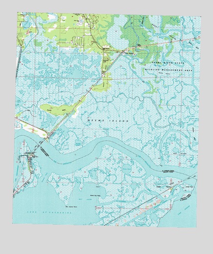
Rigolets, LA USGS Topographic Map
Click on map above to begin viewing in our Map Viewer.

This topographic map contains these locations and features:
Feature Name Type Latitude Longitude GNIS ID View Map
Apple Pie RidgeRidgeN30.2141°W89.6889°559791View Map
Avery EstatesPopulated PlaceN30.2341°W89.7087°1628845View Map
Bay JauneBayN30.1402°W89.7020°532363View Map
Bay Jaune PointCapeN30.1380°W89.7134°532364View Map
Bayou Bay JauneGutN30.1583°W89.6956°532439View Map
Catfish PointCapeN30.1494°W89.6301°533826View Map
Chalon BayouStreamN30.2419°W89.6364°560395View Map
Corridor BayouGutN30.1330°W89.6834°534147View Map
Counterfeit PassGutN30.1510°W89.6773°534184View Map
Deer IslandPopulated PlaceN30.2291°W89.6684°1629063View Map
Desert IslandIslandN30.2324°W89.6295°560623View Map
Double Bayou LagoonLakeN30.1797°W89.7175°560642View Map
East Double BayouGutN30.1746°W89.7156°560686View Map
East MouthChannelN30.1708°W89.6287°560692View Map
Fawn BayouLakeN30.2473°W89.6396°560733View Map
Fort Pike BridgeBridgeN30.1713°W89.7328°560780View Map
Fort Pike CanalChannelN30.1549°W89.7362°543879View Map
Fort Pike Gas FieldOilfieldN30.1441°W89.6878°558023View Map
Fort Pike State Historic SiteParkN30.1671°W89.7367°558223View Map
Foster BayouLakeN30.1856°W89.6668°560784View Map
Fritchie MarshSwampN30.2193°W89.7246°560804View Map
Geoghegan CanalCanalN30.1805°W89.7214°560825View Map
Goose PondLakeN30.1593°W89.6733°554556View Map
Goose Pond BayouGutN30.1633°W89.6687°535288View Map
Grand Coin BayouGutN30.1527°W89.7145°535328View Map
Grand Coin PocketBayN30.1516°W89.7062°535329View Map
Grand Cop PointCapeN30.1416°W89.6906°535330View Map
Graves DitchChannelN30.2391°W89.6523°560895View Map
Hog IslandIslandN30.1671°W89.6337°560978View Map
Honey IslandIslandN30.2171°W89.6498°560994View Map
Hospital PassGutN30.1338°W89.6895°535823View Map
Joes LagoonLakeN30.1897°W89.6305°1627360View Map
Johnson IslandIslandN30.1799°W89.6267°1627369View Map
Johnson PassChannelN30.1869°W89.6287°1627372View Map
Jug BayouStreamN30.2416°W89.6298°1627379View Map
Lake Saint CatherineLakeN30.1273°W89.7305°558306View Map
Lily LagoonLakeN30.1907°W89.6330°1627482View Map
Little Deedie LakeBayN30.1251°W89.6617°555068View Map
Little LagoonLakeN30.1970°W89.7495°1627524View Map
Lower Black BayouLakeN30.2071°W89.6461°1627575View Map
McKean CemeteryCemeteryN30.2152°W89.6906°1628953View Map
Mill BayouStreamN30.2438°W89.6642°1627660View Map
Northshore Mobile Home ParkPopulated PlaceN30.2462°W89.7070°2600858View Map
Parish Governing Authority District 13CivilN30.2110°W89.7048°1929845View Map
Perdido BayouGutN30.1927°W89.6956°1627901View Map
Petites CoquillesIslandN30.1577°W89.7395°558024View Map
Pike FortPopulated PlaceN30.1660°W89.7384°543878View Map
Prevost IslandIslandN30.1921°W89.7214°1628002View Map
Rabbit IslandIslandN30.1505°W89.6467°538463View Map
Richardson BayouGutN30.2377°W89.6603°1628052View Map
Ridge Memorial ChurchChurchN30.2299°W89.6909°1628057View Map
RigoletsPopulated PlaceN30.1488°W89.6423°543623View Map
Rigolets Seaplane BaseAirportN30.1419°W89.6476°1632947View Map
Saint Catherine PassGutN30.1399°W89.6714°538816View Map
Salt BayouLakeN30.2018°W89.6806°1628162View Map
Sawmill BayouLakeN30.1915°W89.6436°1628184View Map
Sawmill PassGutN30.1538°W89.7278°539201View Map
Seven LagoonsBayN30.1322°W89.6554°556002View Map
Stump BayouGutN30.1755°W89.7017°1628303View Map
Stump LagoonLakeN30.1739°W89.7067°1628306View Map
The RigoletsGutN30.1544°W89.6253°540673View Map
Toumer Mill PondLakeN30.1855°W89.6372°1628373View Map
Trout BayouGutN30.1769°W89.6709°1628381View Map
Upper Black BayouLakeN30.2204°W89.6518°1628406View Map
Weems IslandIslandN30.1871°W89.6862°1628456View Map
West Double BayouGutN30.1758°W89.7195°1628468View Map
West MouthChannelN30.1696°W89.6506°1628478View Map
West Pearl RiverStreamN30.1613°W89.6484°1628481View Map
White KitchenPopulated PlaceN30.2280°W89.6773°1628494View Map

Note: Coordinates in the location and feature list above are referenced to NAD83 datum.


Copyright (C) 2008-2025 Ryan Niemi / Sunset Dynamics ... All Rights Reserved