TopoQuest Logo
Do you find TopoQuest useful?
Help keep TopoQuest running and adding new maps/features by donating!
Bitcoin:  19c7KJd3qBynnjoSw5npx9KScwjBe4ifkT
Litecoin:  LXs6TkuXGGXo1vDsWCkWVdjQX94eUKd6ui
Home View Maps Find Maps Find Places Resources & Links


English Lookout, Louisiana Topographic Map

USGS Map Title: English Lookout, LA
USGS Map MRC: 30089B5
DRG (GeoTIFF) Download: o30089b5.tif


Neighboring USGS Topographic Map Quads:


  Haaswood, LA  
30089C6
 

  Logtown, MS  
30089C5
 

  Waveland, MS  
30089C4
 

  Rigolets, LA  
30089B6
 

  English Lookout, LA  
30089B5
 

  Saint Joe Pass, MS  
30089B4
 

  Alligator Point, LA  
30089A6
 

  False Mouth Bayou, LA  
30089A5
 

  Malheureux Point, LA  
30089A4


Map MRC Location:

N31°
W90°
N31°
W89°
H8 H7 H6 H5 H4 H3 H2 H1
G8 G7 G6 G5 G4 G3 G2 G1
F8 F7 F6 F5 F4 F3 F2 F1
E8 E7 E6 E5 E4 E3 E2 E1
D8 D7 D6 D5 D4 D3 D2 D1
C8 C7 C6 C5 C4 C3 C2 C1
B8 B7 B6 B5 B4 B3 B2 B1
A8 A7 A6 A5 A4 A3 A2 A1
N30°
W90°
N30°
W89°

English Lookout, LA USGS 1:24K Topographic Map Preview:
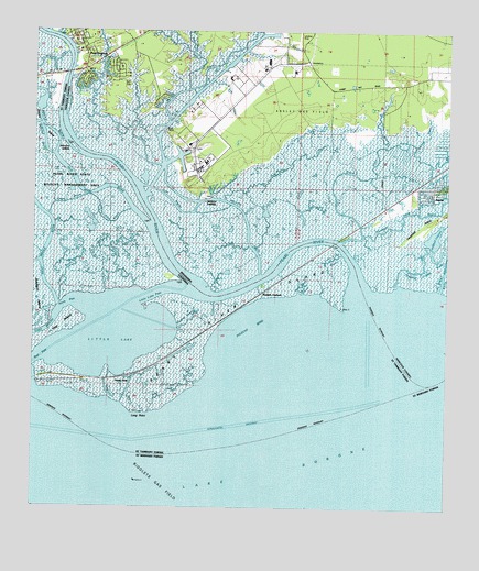
English Lookout, LA USGS Topographic Map
Click on map above to begin viewing in our Map Viewer.

This topographic map contains these locations and features:
Feature Name Type Latitude Longitude GNIS ID View Map
Baldwin Lodge (historical)LocaleN30.1957°W89.5322°689384View Map
Beppo (historical)Populated PlaceN30.2446°W89.5195°689391View Map
Browns DitchCanalN30.2213°W89.6170°1628872View Map
Browns IslandIslandN30.2196°W89.6137°560280View Map
Campbell IslandIslandN30.2024°W89.5017°711731View Map
Campbell LagoonLakeN30.1966°W89.5042°668002View Map
Cowan BayouStreamN30.2146°W89.5862°668895View Map
Cross BayouGutN30.2063°W89.5842°668962View Map
East Middle RiverStreamN30.2177°W89.6189°560691View Map
East PassGutN30.1646°W89.6217°560694View Map
English LookoutLocaleN30.1824°W89.5559°560712View Map
Grand Plains BayouGutN30.2163°W89.5212°670581View Map
Grassy BayouGutN30.2055°W89.6142°560889View Map
J J Waterhouse ClaimCivilN30.1916°W89.5214°671755View Map
Jackson LandingPopulated PlaceN30.2063°W89.5734°691962View Map
John B Doby ClaimCivilN30.2408°W89.5917°671896View Map
John Cane BayouLakeN30.1923°W89.5335°1627361View Map
Johnny Three BayouGutN30.2005°W89.6034°1627362View Map
Johns BayouStreamN30.2202°W89.5192°671905View Map
Kimmels BayouStreamN30.2194°W89.5103°672129View Map
King Bee BayouGutN30.1835°W89.5434°1627407View Map
Kopman BayouLakeN30.1874°W89.6145°1627410View Map
L Boisdore ClaimCivilN30.2194°W89.5720°672228View Map
Little Grassy IslandIslandN30.1721°W89.5289°1628812View Map
Little LakeLakeN30.1685°W89.6014°1627525View Map
Little Lake PassChannelN30.1813°W89.5862°1627527View Map
Long PointCapeN30.1505°W89.5948°1627564View Map
Magnolia RidgeRidgeN30.2094°W89.5092°690047View Map
Middle RiverStreamN30.2180°W89.6192°1627650View Map
Mulatto BayouStreamN30.1869°W89.5564°674456View Map
Mulatto Bayou School (historical)SchoolN30.2363°W89.5139°690048View Map
Nancy Collins ClaimCivilN30.2299°W89.5059°711743View Map
North PassLakeN30.1714°W89.6011°1627792View Map
North SidePopulated PlaceN30.1594°W89.6001°1627799View Map
Old Pearl RiverStreamN30.1988°W89.5898°1627829View Map
Pate BayouStreamN30.2352°W89.5781°675488View Map
Pearl RiverStreamN30.1794°W89.5262°1627887View Map
Pearl River IslandIslandN30.1758°W89.5664°1627889View Map
Pearl River LightLocaleN30.1571°W89.5234°1627890View Map
PearlingtonPopulated PlaceN30.2466°W89.6112°675547View Map
Pearlington Census Designated PlaceCensusN30.2492°W89.6047°2403402View Map
Plantation LandingLocaleN30.2246°W89.5845°689422View Map
Poitevants DitchCanalN30.2421°W89.6214°1627970View Map
Polecat BendBayN30.1727°W89.5587°1627971View Map
Port Bienville Industrial ParkLocaleN30.2270°W89.5647°2596190View Map
Redfish BayouGutN30.1610°W89.5720°1628035View Map
Rigolets Gas FieldOilfieldN30.1560°W89.5931°1629007View Map
Sand BayouLakeN30.1547°W89.6016°1628171View Map
Sand BayouGutN30.1552°W89.5848°1628172View Map
West Hancock Volunteer Fire DepartmentBuildingN30.2466°W89.6117°2332757View Map
West Middle RiverStreamN30.1771°W89.6064°1628477View Map
Whites BayouStreamN30.2352°W89.5784°679632View Map
Woody BayouGutN30.2169°W89.5462°679872View Map
Yousan BayouGutN30.1885°W89.5995°1628546View Map

Note: Coordinates in the location and feature list above are referenced to NAD83 datum.


Copyright (C) 2008-2025 Ryan Niemi / Sunset Dynamics ... All Rights Reserved