TopoQuest Logo
Do you find TopoQuest useful?
Help keep TopoQuest running and adding new maps/features by donating!
Bitcoin:  19c7KJd3qBynnjoSw5npx9KScwjBe4ifkT
Litecoin:  LXs6TkuXGGXo1vDsWCkWVdjQX94eUKd6ui
Home View Maps Find Maps Find Places Resources & Links


Rio Vista, California Topographic Map

USGS Map Title: Rio Vista, CA
USGS Map MRC: 38121B6
DRG (GeoTIFF) Download: o38121b6.tif


Neighboring USGS Topographic Map Quads:


  Dozier, CA  
38121C7
 

  Liberty Island, CA  
38121C6
 

  Courtland, CA  
38121C5
 

  Birds Landing, CA  
38121B7
 

  Rio Vista, CA  
38121B6
 

  Isleton, CA  
38121B5
 

  Antioch North, CA  
38121A7
 

  Jersey Island, CA  
38121A6
 

  Bouldin Island, CA  
38121A5


Map MRC Location:

N39°
W122°
N39°
W121°
H8 H7 H6 H5 H4 H3 H2 H1
G8 G7 G6 G5 G4 G3 G2 G1
F8 F7 F6 F5 F4 F3 F2 F1
E8 E7 E6 E5 E4 E3 E2 E1
D8 D7 D6 D5 D4 D3 D2 D1
C8 C7 C6 C5 C4 C3 C2 C1
B8 B7 B6 B5 B4 B3 B2 B1
A8 A7 A6 A5 A4 A3 A2 A1
N38°
W122°
N38°
W121°

Rio Vista, CA USGS 1:24K Topographic Map Preview:
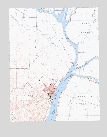
Rio Vista, CA USGS Topographic Map
Click on map above to begin viewing in our Map Viewer.

This topographic map contains these locations and features:
Feature Name Type Latitude Longitude GNIS ID View Map
Brannan IslandIslandN38.1466°W121.6480°219784View Map
Bruna Vista ParkParkN38.1605°W121.6975°1799970View Map
Bruning ParkParkN38.1566°W121.6941°1799971View Map
Cache SloughStreamN38.1788°W121.6666°220358View Map
Cache Slough Gas FieldOilfieldN38.2166°W121.6777°277324View Map
Church of ChristChurchN38.1577°W121.6925°1799977View Map
City of Rio VistaCivilN38.1761°W121.7034°2410955View Map
Cliff House Fishing Access AreaParkN38.1816°W121.6647°1827028View Map
Coast Guard Station Rio VistaMilitaryN38.1458°W121.6941°2512137View Map
D H White Elementary SchoolSchoolN38.1653°W121.6940°237680View Map
Delta MarinaLocaleN38.1499°W121.6936°1799993View Map
Elkhorn SloughStreamN38.2085°W121.6575°253727View Map
Hastings FerryCrossingN38.2466°W121.6966°1666068View Map
Ida IslandIslandN38.1705°W121.6366°225823View Map
Isleton DivisionCivilN38.1704°W121.6254°1935070View Map
Jackson SloughGutN38.1294°W121.6252°226097View Map
KRVH-FM (Rio Vista)TowerN38.1546°W121.6977°1665076View Map
Liberty Island FerryLocaleN38.2391°W121.6858°227064View Map
Liberty Island Gas FieldOilfieldN38.2466°W121.6833°277329View Map
Lindsey SloughStreamN38.2444°W121.6911°227164View Map
Lindsey Slough Gas FieldOilfieldN38.2255°W121.7333°277330View Map
Los UlpinosCivilN38.1463°W121.7125°227687View Map
Miner SloughStreamN38.2330°W121.6725°228791View Map
Montezuma Fire Protection District Rio Vista StationBuildingN38.1578°W121.6928°2623758View Map
NewtownPopulated PlaceN38.1688°W121.6802°1666073View Map
Prospect SloughStreamN38.2391°W121.6841°231072View Map
Rio VistaPopulated PlaceN38.1558°W121.6913°277585View Map
Rio Vista Assembly of God ChurchChurchN38.1646°W121.7011°1800055View Map
Rio Vista BridgeBridgeN38.1583°W121.6822°1827054View Map
Rio Vista City HallBuildingN38.1549°W121.6902°1800056View Map
Rio Vista Fire Department - Delta Fire Protection District Main StationBuildingN38.1577°W121.6927°2623766View Map
Rio Vista Gas FieldOilfieldN38.1471°W121.7275°277336View Map
Rio Vista Gas FieldOilfieldN38.1496°W121.6352°277337View Map
Rio Vista High SchoolSchoolN38.1546°W121.6977°1800057View Map
Rio Vista Municipal AirportAirportN38.1927°W121.7027°1653883View Map
Rio Vista MuseumBuildingN38.1560°W121.6908°1800058View Map
Rio Vista Police DepartmentBuildingN38.1700°W121.6888°2755766View Map
Rio Vista Post OfficePost OfficeN38.1571°W121.6904°2780984View Map
Rio Vista Public LibraryBuildingN38.1566°W121.6919°1800059View Map
Riverview Elementary SchoolSchoolN38.1519°W121.6947°231658View Map
Ryer IslandIslandN38.2405°W121.6341°234597View Map
Ryer Island FerryLocaleN38.1866°W121.6605°232072View Map
Saint Joseph Catholic ChurchChurchN38.1571°W121.6950°1800063View Map
Sandy Beach ParkParkN38.1396°W121.6955°1800065View Map
Steamboat SloughStreamN38.1819°W121.6602°235420View Map
The Church of Jesus Christ of Latter Day SaintsChurchN38.1571°W121.6916°1799979View Map
Tomato SloughGutN38.1399°W121.6661°236447View Map
Union Baptist ChurchChurchN38.1585°W121.6991°1800091View Map
Watson HollowValleyN38.2032°W121.6958°237348View Map

Note: Coordinates in the location and feature list above are referenced to NAD83 datum.


Copyright (C) 2008-2025 Ryan Niemi / Sunset Dynamics ... All Rights Reserved