TopoQuest Logo
Do you find TopoQuest useful?
Help keep TopoQuest running and adding new maps/features by donating!
Bitcoin:  19c7KJd3qBynnjoSw5npx9KScwjBe4ifkT
Litecoin:  LXs6TkuXGGXo1vDsWCkWVdjQX94eUKd6ui
Home View Maps Find Maps Find Places Resources & Links


Riverdale, Virginia Topographic Map

USGS Map Title: Riverdale, VA
USGS Map MRC: 36076E8
DRG (GeoTIFF) Download: o36076e8.tif


Neighboring USGS Topographic Map Quads:


  Courtland, VA  
36077F1
 

  Franklin, VA  
36076F8
 

  Holland, VA  
36076F7
 

  Sunbeam, VA  
36077E1
 

  Riverdale, VA  
36076E8
 

  Gates, NC  
36076E7
 

  Murfreesboro, NC  
36077D1
 

  Winton, NC  
36076D8
 

  Gatesville, NC  
36076D7


Map MRC Location:

N37°
W77°
N37°
W76°
H8 H7 H6 H5 H4 H3 H2 H1
G8 G7 G6 G5 G4 G3 G2 G1
F8 F7 F6 F5 F4 F3 F2 F1
E8 E7 E6 E5 E4 E3 E2 E1
D8 D7 D6 D5 D4 D3 D2 D1
C8 C7 C6 C5 C4 C3 C2 C1
B8 B7 B6 B5 B4 B3 B2 B1
A8 A7 A6 A5 A4 A3 A2 A1
N36°
W77°
N36°
W76°

Riverdale, VA USGS 1:24K Topographic Map Preview:
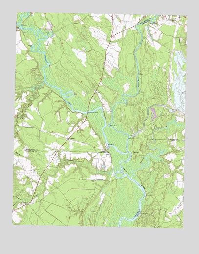
Riverdale, VA USGS Topographic Map
Click on map above to begin viewing in our Map Viewer.

This topographic map contains these locations and features:
Feature Name Type Latitude Longitude GNIS ID View Map
Battle BeachLocaleN36.5482°W76.9313°1462830View Map
Beaman BranchStreamN36.5146°W76.9958°980684View Map
Bethany Church (historical)ChurchN36.6160°W76.9200°1738970View Map
Blackwater RiverStreamN36.5438°W76.9161°1478230View Map
Bronco Rod and Gun ClubLocaleN36.5938°W76.9744°1738973View Map
Buckhorn CreekStreamN36.5327°W76.9205°982144View Map
C-PondReservoirN36.5702°W76.8813°1501732View Map
C-Pond DamDamN36.5702°W76.8813°1501731View Map
Cathole LandingLocaleN36.5585°W76.8919°1499224View Map
Cherry GrovePopulated PlaceN36.5718°W76.9180°1499243View Map
Cobbs WharfLocaleN36.5682°W76.9280°1465032View Map
Cox LandingLocaleN36.5899°W76.9094°1499298View Map
Crossville (historical)LocaleN36.5107°W76.8911°1018703View Map
D-PondReservoirN36.5535°W76.9130°1501734View Map
D-Pond DamDamN36.5535°W76.9130°1501733View Map
Diamond Grove ChurchChurchN36.5574°W76.9858°1465755View Map
Diamond Grove School (historical)SchoolN36.5574°W76.9864°1738987View Map
Gatlington LandingLocaleN36.5085°W76.9063°1020405View Map
General Vaughan BridgeBridgeN36.5668°W76.9464°1467029View Map
Georges BendBendN36.6213°W76.8997°1467040View Map
Holland NurseryBuildingN36.6225°W76.9183°2677727View Map
Jernigan BranchStreamN36.5413°W76.8955°987573View Map
Macks WharfLocaleN36.5193°W76.9022°989215View Map
Manning Ferry (historical)LocaleN36.5288°W76.9122°1003371View Map
Milk LandingLocaleN36.6113°W76.9066°1499745View Map
Mill CreekStreamN36.5838°W76.9777°1470498View Map
Mill Creek LandingLocaleN36.5835°W76.9805°1499746View Map
Mill NeckPopulated PlaceN36.5135°W76.9866°1021458View Map
Monroe BridgeBridgeN36.6171°W76.9972°1470676View Map
Mount Olive ChurchChurchN36.5552°W76.9552°1470959View Map
Nottoway RiverStreamN36.5438°W76.9161°1471681View Map
Point BeachCliffN36.5782°W76.9564°1472561View Map
Riddicks LandingPopulated PlaceN36.5313°W76.9255°1022284View Map
RiddicksvillePopulated PlaceN36.5274°W76.9389°993332View Map
RiverdalePopulated PlaceN36.5513°W76.9597°1477686View Map
Round GutGutN36.6132°W76.9730°1473572View Map
Sandy Hill School (historical)SchoolN36.6046°W76.9427°1739025View Map
Sandy LandingLocaleN36.5788°W76.9091°1500026View Map
Simms GutGutN36.6027°W76.9880°1474610View Map
Smiths BendBendN36.5596°W76.9300°1479645View Map
Smiths Ferry (historical)CrossingN36.5702°W76.9364°1739028View Map
Somerton CreekStreamN36.5288°W76.9130°1025714View Map
South QuayPopulated PlaceN36.6224°W76.8886°1479651View Map
Southampton Meadows Census Designated PlaceCensusN36.5916°W76.9293°2629845View Map
Still LandingLocaleN36.5663°W76.9480°1739032View Map
Sweepstakes (historical)Populated PlaceN36.5554°W76.9333°1739033View Map
WyanokePopulated PlaceN36.5438°W76.9116°1025811View Map

Note: Coordinates in the location and feature list above are referenced to NAD83 datum.


Copyright (C) 2008-2025 Ryan Niemi / Sunset Dynamics ... All Rights Reserved