TopoQuest Logo
Do you find TopoQuest useful?
Help keep TopoQuest running and adding new maps/features by donating!
Bitcoin:  19c7KJd3qBynnjoSw5npx9KScwjBe4ifkT
Litecoin:  LXs6TkuXGGXo1vDsWCkWVdjQX94eUKd6ui
Home View Maps Find Maps Find Places Resources & Links


Murfreesboro, North Carolina Topographic Map

USGS Map Title: Murfreesboro, NC
USGS Map MRC: 36077D1
DRG (GeoTIFF) Download: o36077d1.tif


Neighboring USGS Topographic Map Quads:


  Boykins, VA  
36077E2
 

  Sunbeam, VA  
36077E1
 

  Riverdale, VA  
36076E8
 

  Conway, NC  
36077D2
 

  Murfreesboro, NC  
36077D1
 

  Winton, NC  
36076D8
 

  Woodland, NC  
36077C2
 

  Union, NC  
36077C1
 

  Ahoskie, NC  
36076C8


Map MRC Location:

N37°
W78°
N37°
W77°
H8 H7 H6 H5 H4 H3 H2 H1
G8 G7 G6 G5 G4 G3 G2 G1
F8 F7 F6 F5 F4 F3 F2 F1
E8 E7 E6 E5 E4 E3 E2 E1
D8 D7 D6 D5 D4 D3 D2 D1
C8 C7 C6 C5 C4 C3 C2 C1
B8 B7 B6 B5 B4 B3 B2 B1
A8 A7 A6 A5 A4 A3 A2 A1
N36°
W78°
N36°
W77°

Murfreesboro, NC USGS 1:24K Topographic Map Preview:
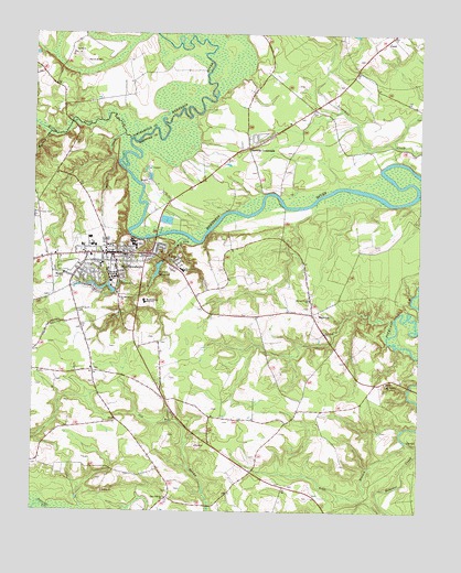
Murfreesboro, NC USGS Topographic Map
Click on map above to begin viewing in our Map Viewer.

This topographic map contains these locations and features:
Feature Name Type Latitude Longitude GNIS ID View Map
Banks CreekStreamN36.4740°W77.0958°980526View Map
Barretts CrossroadsPopulated PlaceN36.4704°W77.0555°980585View Map
Bells BranchStreamN36.3935°W77.0038°980958View Map
Buena VistaPopulated PlaceN36.4418°W77.1194°1003409View Map
Chittys StoreLocaleN36.3988°W77.0972°1003396View Map
Chowan UniversitySchoolN36.4359°W77.0978°983163View Map
Chowan University - McDowell Columns HallSchoolN36.4363°W77.0991°2505204View Map
Chowan University - Robert Marks HallSchoolN36.4375°W77.0978°2505214View Map
Chowan University - Belk Residence HallBuildingN36.4394°W77.0982°2505713View Map
Chowan University - Camp HallSchoolN36.4352°W77.0987°2505205View Map
Chowan University - Daniel HallSchoolN36.4363°W77.0973°2505206View Map
Chowan University - Dunn Residence HallBuildingN36.4382°W77.1008°2505714View Map
Chowan University - Green HallSchoolN36.4367°W77.1002°2505207View Map
Chowan University - Hawks Nest Student CenterSchoolN36.4353°W77.0995°2505208View Map
Chowan University - Helms CenterSchoolN36.4333°W77.0955°2505209View Map
Chowan University - Horner Graphics CenterSchoolN36.4352°W77.0975°2505210View Map
Chowan University - Jenkins CenterSchoolN36.4390°W77.1028°2505211View Map
Chowan University - McSweeny HallSchoolN36.4369°W77.0978°2505212View Map
Chowan University - Mixon Residence HallBuildingN36.4377°W77.1003°2505715View Map
Chowan University - Parker Residence HallBuildingN36.4322°W77.0975°2505716View Map
Chowan University - Penny HallSchoolN36.4358°W77.0987°2505213View Map
Chowan University - Simons Residence HallBuildingN36.4385°W77.1004°2505723View Map
Chowan University - Whitaker LibraryBuildingN36.4364°W77.0977°2506329View Map
College BranchStreamN36.4332°W77.0877°983375View Map
Griffith Landing (historical)LocaleN36.4488°W77.0664°1003400View Map
Hares BranchStreamN36.4360°W77.0861°986404View Map
High HillPopulated PlaceN36.4404°W77.0777°1003399View Map
Hills BridgeBridgeN36.4082°W77.0025°1003395View Map
Hills Ferry (historical)LocaleN36.4557°W77.0436°1003401View Map
Kirbys CreekStreamN36.4727°W77.0939°988018View Map
MapletonPopulated PlaceN36.4268°W77.0347°1021343View Map
Meherrin ChurchChurchN36.4371°W77.1147°989709View Map
Mount Tabor ChurchChurchN36.4090°W77.0100°990589View Map
MurfreesboroPopulated PlaceN36.4424°W77.0986°1021587View Map
Murfreesboro Fire DepartmentBuildingN36.4455°W77.0990°2638521View Map
Murfreesboro High SchoolSchoolN36.4304°W77.0886°990801View Map
Murfreesboro Police DepartmentBuildingN36.4447°W77.0998°2130837View Map
Murfreesboro Post OfficePost OfficeN36.4430°W77.1013°2505384View Map
Murfreesboro Rescue SquadBuildingN36.4458°W77.0990°2720330View Map
New Heaven ChurchChurchN36.3788°W77.0811°990973View Map
Parker Grove ChurchChurchN36.4307°W77.0355°991865View Map
PrincetonLocaleN36.4835°W77.0914°1006746View Map
Riverview Elementary SchoolSchoolN36.4385°W77.0764°993401View Map
Saint Barnabas ChurchChurchN36.4310°W77.0969°993873View Map
Saint Pauls ChurchChurchN36.4407°W77.0791°994102View Map
Sears Wharf (historical)LocaleN36.4649°W77.0130°1003406View Map
Shell LandingLocaleN36.4738°W77.0830°1006747View Map
Skinners Bridge Landing (historical)LocaleN36.4821°W77.0664°1003398View Map
Solid Rock ChurchChurchN36.4218°W77.0302°995102View Map
Town of MurfreesboroCivilN36.4421°W77.0966°2406219View Map
Township of MurfreesboroCivilN36.4161°W77.0665°1026797View Map
Turkey CreekStreamN36.4674°W77.1247°996330View Map
Whorrells Millpond DamDamN36.4402°W77.0830°1000627View Map
Worrell Landing (historical)LocaleN36.4671°W77.0902°1003397View Map
Worrell Mill SwampStreamN36.4468°W77.0744°997640View Map
Worrell MillpondReservoirN36.4385°W77.0844°997641View Map

Note: Coordinates in the location and feature list above are referenced to NAD83 datum.


Copyright (C) 2008-2025 Ryan Niemi / Sunset Dynamics ... All Rights Reserved