TopoQuest Logo
Do you find TopoQuest useful?
Help keep TopoQuest running and adding new maps/features by donating!
Bitcoin:  19c7KJd3qBynnjoSw5npx9KScwjBe4ifkT
Litecoin:  LXs6TkuXGGXo1vDsWCkWVdjQX94eUKd6ui
Home View Maps Find Maps Find Places Resources & Links


Roanoke Rapids, North Carolina Topographic Map

USGS Map Title: Roanoke Rapids, NC
USGS Map MRC: 36077D6
DRG (GeoTIFF) Download: o36077d6.tif


Neighboring USGS Topographic Map Quads:


  Valentines, VA  
36077E7
 

  Barley, VA  
36077E6
 

  Skippers, VA  
36077E5
 

  Thelma, NC  
36077D7
 

  Roanoke Rapids, NC  
36077D6
 

  Weldon, NC  
36077D5
 

  Aurelian Springs, NC  
36077C7
 

  Darlington, NC  
36077C6
 

  Halifax, NC  
36077C5


Map MRC Location:

N37°
W78°
N37°
W77°
H8 H7 H6 H5 H4 H3 H2 H1
G8 G7 G6 G5 G4 G3 G2 G1
F8 F7 F6 F5 F4 F3 F2 F1
E8 E7 E6 E5 E4 E3 E2 E1
D8 D7 D6 D5 D4 D3 D2 D1
C8 C7 C6 C5 C4 C3 C2 C1
B8 B7 B6 B5 B4 B3 B2 B1
A8 A7 A6 A5 A4 A3 A2 A1
N36°
W78°
N36°
W77°

Roanoke Rapids, NC USGS 1:24K Topographic Map Preview:
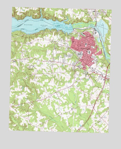
Roanoke Rapids, NC USGS Topographic Map
Click on map above to begin viewing in our Map Viewer.

This topographic map contains these locations and features:
Feature Name Type Latitude Longitude GNIS ID View Map
Akers SchoolSchoolN36.4640°W77.6511°980071View Map
Becker Village Shopping CenterLocaleN36.4599°W77.6694°1007353View Map
BelmontPopulated PlaceN36.4649°W77.6797°1019081View Map
Bethlehem ChurchChurchN36.4474°W77.7375°981231View Map
Bible Way ChurchChurchN36.4640°W77.7283°981294View Map
Black Duck CreekStreamN36.4879°W77.6444°1019193View Map
BollingPopulated PlaceN36.4652°W77.6941°1023555View Map
Boseman ChurchChurchN36.4304°W77.6686°981748View Map
Calvary ChurchChurchN36.4665°W77.6716°982464View Map
Cedarwood CemeteryCemeteryN36.4718°W77.6653°982908View Map
Central ChurchChurchN36.4460°W77.6450°982960View Map
Chaloner ParkParkN36.4429°W77.6608°982991View Map
Chaloner SchoolSchoolN36.4415°W77.6586°982992View Map
Chantilly SpeedwayLocaleN36.3877°W77.6350°983000View Map
Chockoyotte ChurchChurchN36.4315°W77.6350°983158View Map
City of Roanoke RapidsCivilN36.4453°W77.6491°2404628View Map
Cool Spring ChurchChurchN36.4977°W77.6544°983486View Map
Crestview Memorial CemeteryCemeteryN36.4313°W77.6539°983740View Map
Davie Middle SchoolSchoolN36.4449°W77.7453°983981View Map
Davie Volunteer Fire Department Station 1 HeadquartersBuildingN36.4457°W77.6995°2638744View Map
Davis Recreation CenterBuildingN36.4615°W77.6475°984015View Map
Days CrossroadsPopulated PlaceN36.3904°W77.6339°1019927View Map
Enfield Police DepartmentBuildingN36.4452°W77.6990°2131018View Map
Faith TabernacleChurchN36.4718°W77.6464°984966View Map
First Evangelical ChurchChurchN36.4971°W77.6339°985088View Map
Forest Hills Shopping CenterLocaleN36.4640°W77.6872°1007354View Map
Gaston Junior High SchoolSchoolN36.4979°W77.6461°1006741View Map
Gaston Police DepartmentBuildingN36.4952°W77.6431°2130843View Map
Gaston Post OfficePost OfficeN36.4997°W77.6447°2774201View Map
Gaston Volunteer Rescue SquadBuildingN36.4953°W77.6426°2720366View Map
Good News ChurchChurchN36.4335°W77.6664°985794View Map
Gum ChapelChurchN36.4465°W77.7000°986213View Map
Halifax AcademySchoolN36.3982°W77.6711°986305View Map
Halifax County Airport (historical)AirportN36.4430°W77.7090°998073View Map
Halifax Emergency Medical Services Station 6BuildingN36.4388°W77.6472°2720585View Map
Halifax Regional Medical CenterHospitalN36.4318°W77.6464°2701511View Map
Hearn SchoolSchoolN36.4635°W77.6630°986571View Map
Highway ChurchChurchN36.4590°W77.6947°986785View Map
Lake View Park ChurchChurchN36.4704°W77.6875°988087View Map
Lake WilliamsReservoirN36.4746°W77.6602°997392View Map
Lees CreekStreamN36.4879°W77.6433°988314View Map
Little RiverStreamN36.4799°W77.6886°988753View Map
London ChurchChurchN36.4504°W77.7289°988868View Map
New Hope ChurchChurchN36.4477°W77.7322°991033View Map
North Carolina State Highway Patrol Troop C District 8BuildingN36.4034°W77.6473°2130973View Map
Park ChurchChurchN36.4471°W77.6475°991851View Map
Poplar Grove CemeteryCemeteryN36.4560°W77.6647°992690View Map
Quankey ChurchChurchN36.4096°W77.7003°992935View Map
RheasvillePopulated PlaceN36.4104°W77.7003°1022234View Map
Rheasville Volunteer Fire DepartmentBuildingN36.4093°W77.7037°2638094View Map
Roanoke ChurchChurchN36.4724°W77.6553°993415View Map
Roanoke RapidsPopulated PlaceN36.4615°W77.6541°1022310View Map
Roanoke Rapids Air Force Station (historical)MilitaryN36.4400°W77.7239°2089931View Map
Roanoke Rapids Fire Department Station 1 HeadquartersBuildingN36.4619°W77.6548°2638494View Map
Roanoke Rapids Fire Department Station 2BuildingN36.4249°W77.6464°2638249View Map
Roanoke Rapids LakeReservoirN36.4858°W77.7422°993420View Map
Roanoke Rapids Lake DamDamN36.4815°W77.6733°1000678View Map
Roanoke Rapids PlazaLocaleN36.4613°W77.6775°1007357View Map
Roanoke Rapids Police DepartmentBuildingN36.4679°W77.6876°2130920View Map
Roanoke Rapids Police DepartmentBuildingN36.4425°W77.6490°2130959View Map
Roanoke Rapids Police DepartmentBuildingN36.4545°W77.6575°2130987View Map
Roanoke Rapids Post OfficePost OfficeN36.4606°W77.6556°2774272View Map
Roanoke Valley Rescue SquadBuildingN36.4687°W77.6486°2720692View Map
Rochelle Pond DamDamN36.4752°W77.6614°1000668View Map
RosemaryPopulated PlaceN36.4513°W77.6794°1022398View Map
Saint Johns ChurchChurchN36.4571°W77.6547°993971View Map
Saint Marks ChurchChurchN36.4318°W77.7228°994023View Map
Shearins ChapelChurchN36.4635°W77.7261°994609View Map
Simmons Grove ChurchChurchN36.4613°W77.6878°994843View Map
Smiths ChurchChurchN36.4271°W77.6655°995003View Map
South RosemaryPopulated PlaceN36.4515°W77.6972°1867441View Map
South Rosemary Census Designated PlaceCensusN36.4463°W77.7064°2402876View Map
Stevenson PondReservoirN36.4202°W77.7330°1000611View Map
Stevenson Pond DamDamN36.4202°W77.7330°1000610View Map
Tabernacle ChurchChurchN36.4593°W77.6789°995813View Map
Town of GastonCivilN36.4965°W77.6448°2406550View Map
Township of Roanoke RapidsCivilN36.4494°W77.7054°1026756View Map
Township of WeldonCivilN36.4009°W77.6271°1026759View Map
Twilight ChurchChurchN36.3854°W77.6391°996382View Map
W L Manning Elementary SchoolSchoolN36.4521°W77.6436°1024837View Map
W T Medlin Elementary SchoolSchoolN36.4713°W77.6580°1024838View Map
WCBT-AM (Roanoke Rapids)TowerN36.4460°W77.6639°1018572View Map
White ChurchChurchN36.4665°W77.6722°997131View Map
WPGT-FM (Roanoke Rapids)TowerN36.4371°W77.6364°1018348View Map
WPGT-FM (Roanoke Rapids)TowerN36.4674°W77.6514°1018350View Map
WPTM-FM (Roanoke Rapids)TowerN36.4093°W77.6836°1018347View Map
Wrights PondReservoirN36.4425°W77.6840°1000630View Map
Wrights Pond DamDamN36.4418°W77.6830°1000631View Map

Note: Coordinates in the location and feature list above are referenced to NAD83 datum.


Copyright (C) 2008-2024 Ryan Niemi / Sunset Dynamics ... All Rights Reserved