TopoQuest Logo
Do you find TopoQuest useful?
Help keep TopoQuest running and adding new maps/features by donating!
Bitcoin:  19c7KJd3qBynnjoSw5npx9KScwjBe4ifkT
Litecoin:  LXs6TkuXGGXo1vDsWCkWVdjQX94eUKd6ui
Home View Maps Find Maps Find Places Resources & Links


Rob Roy, Arkansas Topographic Map

USGS Map Title: Rob Roy, AR
USGS Map MRC: 34091C8
DRG (GeoTIFF) Download: o34091c8.tif


Neighboring USGS Topographic Map Quads:


  Wright, AR  
34092D1
 

  Sherrill, AR  
34091D8
 

  Gethsemane, AR  
34091D7
 

  White Hall, AR  
34092C1
 

  Rob Roy, AR  
34091C8
 

  Altheimer, AR  
34091C7
 

  Pine Bluff, AR  
34092B1
 

  Ladd, AR  
34091B8
 

  Moscow, AR  
34091B7


Map MRC Location:

N35°
W92°
N35°
W91°
H8 H7 H6 H5 H4 H3 H2 H1
G8 G7 G6 G5 G4 G3 G2 G1
F8 F7 F6 F5 F4 F3 F2 F1
E8 E7 E6 E5 E4 E3 E2 E1
D8 D7 D6 D5 D4 D3 D2 D1
C8 C7 C6 C5 C4 C3 C2 C1
B8 B7 B6 B5 B4 B3 B2 B1
A8 A7 A6 A5 A4 A3 A2 A1
N34°
W92°
N34°
W91°

Rob Roy, AR USGS 1:24K Topographic Map Preview:
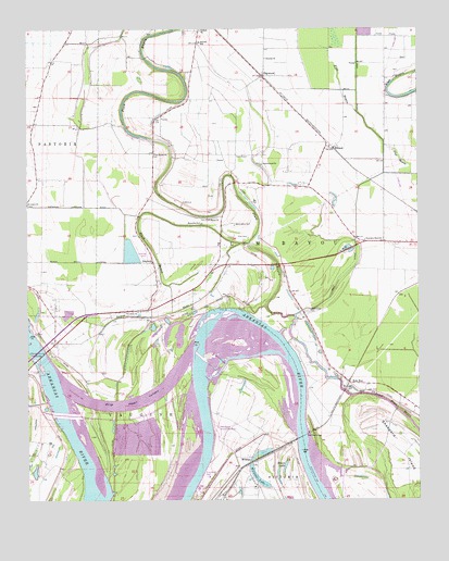
Rob Roy, AR USGS Topographic Map
Click on map above to begin viewing in our Map Viewer.

This topographic map contains these locations and features:
Feature Name Type Latitude Longitude GNIS ID View Map
Bayou PeteStreamN34.3182°W91.9324°46181View Map
Bethlehem Church (historical)ChurchN34.2754°W91.8807°63901View Map
Black BayouStreamN34.3182°W91.9296°46652View Map
Black Bayou LateralCanalN34.3137°W91.9821°46653View Map
Boyd Point CutoffChannelN34.2768°W91.9640°46876View Map
Brean LakeLakeN34.2591°W91.9181°75659View Map
Brushy Lake (historical)LakeN34.3582°W91.9882°63907View Map
Corinth ChurchChurchN34.3745°W91.9449°48049View Map
Cottonwood CemeteryCemeteryN34.2999°W91.9103°76684View Map
Cottonwood ChurchChurchN34.3393°W91.9254°48072View Map
Dumbeck Spur (historical)LocaleN34.2723°W91.9140°63920View Map
EllisonPopulated PlaceN34.3437°W91.9021°76872View Map
Fergus CrossingCrossingN34.2540°W91.9518°63923View Map
Fish Point (historical)CapeN34.2970°W91.9396°63924View Map
Greenleaf LandingLocaleN34.2612°W91.9043°63932View Map
HaywoodPopulated PlaceN34.3629°W91.9249°49967View Map
Island Harbor Volunteer Fire DepartmentBuildingN34.2740°W91.9518°2116622View Map
Jefferson CountyCivilN34.2688°W91.9315°66862View Map
Jefferson County Free BridgeBridgeN34.2879°W91.9968°50607View Map
Kelly Island (historical)IslandN34.2515°W91.9510°63936View Map
Lateral D-1CanalN34.3473°W91.9835°60895View Map
Lateral D-2CanalN34.3604°W91.9751°63945View Map
Lateral D-3CanalN34.3570°W91.9835°63946View Map
Lateral Number 1CanalN34.3362°W91.8768°63947View Map
Lateral Number 2CanalN34.3590°W91.9068°60897View Map
Lateral Number 3CanalN34.3732°W91.8843°60898View Map
New Hope Church (historical)ChurchN34.2995°W91.9107°63966View Map
Pine Bluff PortLocaleN34.2565°W91.9429°78007View Map
Plum BayouStreamN34.2945°W91.9193°53626View Map
Plum Bayou Church (historical)ChurchN34.3568°W91.9479°63976View Map
Plum Bayou LeveeLeveeN34.2826°W91.9751°63977View Map
Plum Bayou School (historical)SchoolN34.3568°W91.9479°66871View Map
Prayer Lake CemeteryCemeteryN34.2595°W91.9276°63978View Map
Prayer Lake Church (historical)ChurchN34.2598°W91.9276°63979View Map
Reynolds ChurchChurchN34.3237°W91.9449°53998View Map
Rice CemeteryCemeteryN34.3204°W91.9299°54007View Map
Roan Landing (historical)LocaleN34.2934°W91.9262°63984View Map
Rob RoyPopulated PlaceN34.2812°W91.8971°78187View Map
Rob Roy BridgeBridgeN34.2670°W91.9124°54064View Map
Rob Roy ShoalBarN34.2873°W91.9240°63985View Map
Ronoke ChurchChurchN34.3132°W91.9604°54182View Map
Saint John ChurchChurchN34.3001°W91.9687°78239View Map
Saint Johns School (historical)SchoolN34.2995°W91.9693°63989View Map
Saint Lukes CemeteryCemeteryN34.3287°W91.9996°63990View Map
Saint Lukes School (historical)SchoolN34.3354°W91.9974°60896View Map
Saint Marks ChurchChurchN34.3423°W91.9593°54401View Map
Saint Marks School (historical)SchoolN34.3423°W91.9593°63992View Map
Saint Marys CemeteryCemeteryN34.3245°W91.9426°63993View Map
Saint Marys ChurchChurchN34.3248°W91.9429°54414View Map
Sainte Marie BendBendN34.2959°W91.9435°63997View Map
Sainte Marie Public Use AreaParkN34.2693°W91.9396°78452View Map
Sheppard IslandFlatN34.2637°W91.8807°78341View Map
Sherrill SchoolSchoolN34.3715°W91.9454°54768View Map
Sturgen Church (historical)ChurchN34.2695°W91.9362°64001View Map
Sunrise ChurchChurchN34.3673°W91.9240°55344View Map
Sunrise School (historical)SchoolN34.3673°W91.9237°64002View Map
Temple Star Church (historical)ChurchN34.2709°W91.8946°64005View Map
Thomas CemeteryCemeteryN34.3418°W91.9293°55524View Map
Township of Plum BayouCivilN34.3169°W91.8985°66741View Map
Travelers Rest ChurchChurchN34.3190°W91.8924°55640View Map
Travelers Rest School (historical)SchoolN34.3187°W91.8918°64006View Map
Tucker Lake (historical)LakeN34.3590°W91.9813°64008View Map
Washington CemeteryCemeteryN34.3237°W91.9340°56075View Map
Waterloo Drainage DitchCanalN34.3282°W91.9868°56093View Map
WilkinsPopulated PlaceN34.2598°W91.9299°58891View Map
Wilkins LakeLakeN34.2561°W91.9267°75888View Map
Wilkins School (historical)SchoolN34.2587°W91.9262°64014View Map
Willow LakeLakeN34.2551°W91.9200°64016View Map
Winfrey ReachChannelN34.2587°W91.9779°64017View Map
Yell BendBendN34.2848°W91.9940°64018View Map

Note: Coordinates in the location and feature list above are referenced to NAD83 datum.


Copyright (C) 2008-2024 Ryan Niemi / Sunset Dynamics ... All Rights Reserved