TopoQuest Logo
Do you find TopoQuest useful?
Help keep TopoQuest running and adding new maps/features by donating!
Bitcoin:  19c7KJd3qBynnjoSw5npx9KScwjBe4ifkT
Litecoin:  LXs6TkuXGGXo1vDsWCkWVdjQX94eUKd6ui
Home View Maps Find Maps Find Places Resources & Links


Sherrill, Arkansas Topographic Map

USGS Map Title: Sherrill, AR
USGS Map MRC: 34091D8
DRG (GeoTIFF) Download: o34091d8.tif


Neighboring USGS Topographic Map Quads:


  Keo, AR  
34092E1
 

  England, AR  
34091E8
 

  Humnoke, AR  
34091E7
 

  Wright, AR  
34092D1
 

  Sherrill, AR  
34091D8
 

  Gethsemane, AR  
34091D7
 

  White Hall, AR  
34092C1
 

  Rob Roy, AR  
34091C8
 

  Altheimer, AR  
34091C7


Map MRC Location:

N35°
W92°
N35°
W91°
H8 H7 H6 H5 H4 H3 H2 H1
G8 G7 G6 G5 G4 G3 G2 G1
F8 F7 F6 F5 F4 F3 F2 F1
E8 E7 E6 E5 E4 E3 E2 E1
D8 D7 D6 D5 D4 D3 D2 D1
C8 C7 C6 C5 C4 C3 C2 C1
B8 B7 B6 B5 B4 B3 B2 B1
A8 A7 A6 A5 A4 A3 A2 A1
N34°
W92°
N34°
W91°

Sherrill, AR USGS 1:24K Topographic Map Preview:
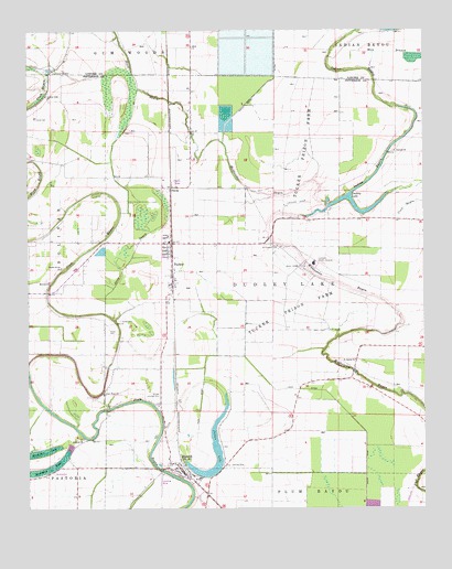
Sherrill, AR USGS Topographic Map
Click on map above to begin viewing in our Map Viewer.

This topographic map contains these locations and features:
Feature Name Type Latitude Longitude GNIS ID View Map
Antioch CemeteryCemeteryN34.3937°W91.9837°63891View Map
Antioch ChurchChurchN34.3934°W91.9821°45897View Map
Antioch School (historical)SchoolN34.3932°W91.9840°63892View Map
Arkansas Department of Corrections Maximum Security UnitBuildingN34.4542°W91.9153°2733391View Map
Arkansas Department of Corrections Tucker UnitBuildingN34.4394°W91.9100°82572View Map
Banks Chapel (historical)ChurchN34.4523°W91.9935°63895View Map
Barrett High SchoolSchoolN34.3832°W91.9460°63896View Map
Black BayouGutN34.4857°W91.9638°46651View Map
Central ChurchChurchN34.4684°W91.8837°47656View Map
County Line ChurchChurchN34.4832°W91.9943°48088View Map
Dudley LakeLakeN34.4536°W91.8911°75701View Map
Dudley Lake School (historical)SchoolN34.4587°W91.8840°63919View Map
FerdaPopulated PlaceN34.4590°W91.9546°57013View Map
Fields CemeteryCemeteryN34.4226°W91.9746°49040View Map
Hendricks CemeteryCemeteryN34.4893°W91.9915°50014View Map
Horseshoe LakeLakeN34.3851°W91.9955°77233View Map
Indian BayouStreamN34.4537°W91.9051°50492View Map
Jones CemeteryCemeteryN34.4773°W91.9974°50726View Map
Lateral Number 2CanalN34.4709°W91.9899°60841View Map
Lateral Number 4CanalN34.3843°W91.9107°60845View Map
Lateral Number 5CanalN34.3912°W91.8843°60847View Map
Lateral Number 6CanalN34.3951°W91.9068°60844View Map
Lateral Number 7CanalN34.4251°W91.9315°60843View Map
Lateral Number 8CanalN34.4118°W91.9490°63951View Map
Main Canal Number 9CanalN34.4704°W91.9732°60842View Map
Main DitchCanalN34.3948°W91.8937°51621View Map
Morrow ChurchChurchN34.4345°W91.9929°52225View Map
Mosby School (historical)SchoolN34.4059°W91.9146°63957View Map
Mount Pleasant CemeteryCemeteryN34.4440°W91.9204°52387View Map
New Hope ChurchChurchN34.4059°W91.9763°52680View Map
Puerto Rico Lake (historical)LakeN34.3965°W91.9182°63980View Map
Rosenwald School (historical)SchoolN34.4448°W91.9385°63986View Map
Saint James ChurchChurchN34.4140°W91.8968°54341View Map
Secrest (historical)Populated PlaceN34.4820°W91.9551°60846View Map
Shady Grove ChurchChurchN34.4379°W91.9890°54710View Map
SherrillPopulated PlaceN34.3854°W91.9507°78344View Map
Sherrill Volunteer Fire DepartmentBuildingN34.3840°W91.9500°2117118View Map
Smith's International AirportAirportN34.4020°W91.9594°63998View Map
Steep BayouStreamN34.4259°W91.9754°55194View Map
Tommy's Flying Service Inc AirportAirportN34.3844°W91.9583°83832View Map
Town of SherrillCivilN34.3846°W91.9516°2407326View Map
Township of Dudley LakeCivilN34.4395°W91.8914°66734View Map
TuckerPopulated PlaceN34.4445°W91.9546°55674View Map
Tucker CemeteryCemeteryN34.4245°W91.9707°55678View Map
Tucker Prison FarmLocaleN34.4443°W91.9143°82571View Map
Tucker Volunteer Fire StationBuildingN34.4406°W91.9539°2117224View Map

Note: Coordinates in the location and feature list above are referenced to NAD83 datum.


Copyright (C) 2008-2025 Ryan Niemi / Sunset Dynamics ... All Rights Reserved