TopoQuest Logo
Do you find TopoQuest useful?
Help keep TopoQuest running and adding new maps/features by donating!
Bitcoin:  19c7KJd3qBynnjoSw5npx9KScwjBe4ifkT
Litecoin:  LXs6TkuXGGXo1vDsWCkWVdjQX94eUKd6ui
Home View Maps Find Maps Find Places Resources & Links


Loranger, Louisiana Topographic Map

USGS Map Title: Loranger, LA
USGS Map MRC: 30090F4
DRG (GeoTIFF) Download: o30090f4.tif


Neighboring USGS Topographic Map Quads:


  Roseland, LA  
30090G5
 

  Chesbrough, LA  
30090G4
 

  Wilmer, LA  
30090G3
 

  Amite, LA  
30090F5
 

  Loranger, LA  
30090F4
 

  Husser, LA  
30090F3
 

  Albany, LA  
30090E5
 

  Hammond, LA  
30090E4
 

  Robert, LA  
30090E3


Map MRC Location:

N31°
W91°
N31°
W90°
H8 H7 H6 H5 H4 H3 H2 H1
G8 G7 G6 G5 G4 G3 G2 G1
F8 F7 F6 F5 F4 F3 F2 F1
E8 E7 E6 E5 E4 E3 E2 E1
D8 D7 D6 D5 D4 D3 D2 D1
C8 C7 C6 C5 C4 C3 C2 C1
B8 B7 B6 B5 B4 B3 B2 B1
A8 A7 A6 A5 A4 A3 A2 A1
N30°
W91°
N30°
W90°

Loranger, LA USGS 1:24K Topographic Map Preview:
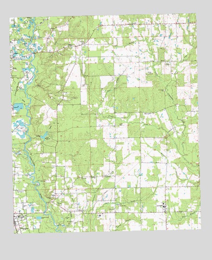
Loranger, LA USGS Topographic Map
Click on map above to begin viewing in our Map Viewer.

This topographic map contains these locations and features:
Feature Name Type Latitude Longitude GNIS ID View Map
Amite CemeteryCemeteryN30.7274°W90.4990°532153View Map
Amite City Wastewater Treatment PlantLocaleN30.7194°W90.4978°2603391View Map
Ballard CemeteryCemeteryN30.7163°W90.4056°532292View Map
Barnett CemeteryCemeteryN30.6455°W90.4740°532318View Map
Bennett CemeteryCemeteryN30.6307°W90.4601°532939View Map
Big CreekStreamN30.7449°W90.4829°540645View Map
Briar Patch CemeteryCemeteryN30.7063°W90.3976°533383View Map
Butler CemeteryCemeteryN30.7166°W90.4998°533584View Map
Camp Whispering PinesLocaleN30.6810°W90.4731°533662View Map
Chappepeela ChurchChurchN30.7449°W90.4184°533879View Map
Church of God in Christ of AmiteChurchN30.7197°W90.4996°2601676View Map
Connor CreekStreamN30.7202°W90.4831°554069View Map
Cooper CemeteryCemeteryN30.6868°W90.4279°534118View Map
Cooper CemeteryCemeteryN30.6910°W90.4231°534119View Map
Cooper ChapelChurchN30.6930°W90.4070°534122View Map
Cooper CreekStreamN30.6680°W90.3859°554080View Map
Cutrer CemeteryCemeteryN30.7102°W90.4520°534331View Map
Donaldson CemeteryCemeteryN30.7210°W90.3937°534560View Map
Dry BranchStreamN30.7355°W90.4112°534595View Map
Ellis CemeteryCemeteryN30.7485°W90.4973°534801View Map
First United Pentecostal ChurchChurchN30.6363°W90.4965°549658View Map
Fleming ChapelChurchN30.6469°W90.4720°535003View Map
Ford CemeteryCemeteryN30.6563°W90.4540°535027View Map
Hayden CemeteryCemeteryN30.6338°W90.4648°535572View Map
Hayden Grove ChurchChurchN30.7324°W90.4593°535573View Map
Independence Elementary SchoolSchoolN30.6349°W90.4959°549686View Map
Independence Fire Department Station 2BuildingN30.6349°W90.5000°2332410View Map
Independence High SchoolSchoolN30.6346°W90.4944°549687View Map
Independence Sewage Treatment PlantLocaleN30.6342°W90.4830°2603443View Map
Indian CreekStreamN30.6799°W90.4873°554823View Map
Landmark Missionary Baptist ChurchChurchN30.6963°W90.4672°2602167View Map
Lawrence Missionary Baptist ChurchChurchN30.6571°W90.4381°555005View Map
Le Blanc FieldAirportN30.6806°W90.4223°2676802View Map
Lee CemeteryCemeteryN30.7357°W90.4018°536390View Map
Light House Baptist ChurchChurchN30.6382°W90.4320°555039View Map
LorangerPopulated PlaceN30.6357°W90.3981°555164View Map
Loranger Baptist ChurchChurchN30.6377°W90.3981°550907View Map
Loranger CemeteryCemeteryN30.6402°W90.4293°536730View Map
Loranger Elementary SchoolSchoolN30.6390°W90.3989°549702View Map
Loranger High SchoolSchoolN30.6407°W90.4001°549703View Map
Loranger Middle SchoolSchoolN30.6390°W90.3999°549704View Map
Loranger Post OfficePost OfficeN30.6351°W90.4018°1631307View Map
Loranger United Methodist ChurchChurchN30.6396°W90.4006°550908View Map
Loranger Volunteer Fire DepartmentBuildingN30.6378°W90.3975°2332599View Map
Lynne CemeteryCemeteryN30.6555°W90.4784°536788View Map
Marburyville (historical)Populated PlaceN30.6391°W90.4640°557093View Map
Mixon BranchStreamN30.7002°W90.4401°537169View Map
Mount Olive Baptist ChurchChurchN30.6424°W90.4701°555398View Map
Oak Grove Church of GodChurchN30.6374°W90.4534°555523View Map
Parish Governing Authority District 4CivilN30.6305°W90.4824°1930038View Map
Peaks CreekStreamN30.7007°W90.3926°538032View Map
Pine Grove ChurchChurchN30.6569°W90.4443°538168View Map
Saint John ChurchChurchN30.6355°W90.3893°538876View Map
San Expedito ChurchChurchN30.6499°W90.4970°539123View Map
Shady Grove ChurchChurchN30.7344°W90.4501°539274View Map
Shiloh ChurchChurchN30.7232°W90.3968°539341View Map
Skyline AirparkAirportN30.7335°W90.4501°1632603View Map
Spring BranchStreamN30.6985°W90.4901°539562View Map
Spring CemeteryCemeteryN30.7432°W90.4701°539580View Map
Stevens CemeteryCemeteryN30.6402°W90.4929°539661View Map
Sweetwater School (historical)SchoolN30.6474°W90.4570°542187View Map
Tangi Pines Nursing CenterBuildingN30.7361°W90.4994°2601140View Map
Tangipahoa ParishCivilN30.6267°W90.4057°559500View Map
Tangipahoa Parish Library Loranger BranchBuildingN30.6361°W90.4008°2603153View Map
Tangipahoa Parish Sheriff's Office Loranger Sub StationBuildingN30.6366°W90.3989°2334071View Map
Tyner CreekStreamN30.7082°W90.4898°540075View Map
Union ChurchChurchN30.7030°W90.4581°540088View Map
VelmaPopulated PlaceN30.6594°W90.4990°549765View Map
Ward FiveCivilN30.6591°W90.4062°545208View Map
Whispering Pines DamDamN30.6802°W90.4801°556963View Map
Wilmer Volunteer Fire Department Station 2BuildingN30.7448°W90.3907°2691799View Map

Note: Coordinates in the location and feature list above are referenced to NAD83 datum.


Copyright (C) 2008-2024 Ryan Niemi / Sunset Dynamics ... All Rights Reserved