TopoQuest Logo
Do you find TopoQuest useful?
Help keep TopoQuest running and adding new maps/features by donating!
Bitcoin:  19c7KJd3qBynnjoSw5npx9KScwjBe4ifkT
Litecoin:  LXs6TkuXGGXo1vDsWCkWVdjQX94eUKd6ui
Home View Maps Find Maps Find Places Resources & Links


Buckhead, Georgia Topographic Map

USGS Map Title: Buckhead, GA
USGS Map MRC: 33083E3
DRG (GeoTIFF) Download: o33083e3.tif


Neighboring USGS Topographic Map Quads:


  Apalachee, GA  
33083F4
 

  Greshamville, GA  
33083F3
 

  Penfield, GA  
33083F2
 

  Madison, GA  
33083E4
 

  Buckhead, GA  
33083E3
 

  Greensboro, GA  
33083E2
 

  Rock Eagle Lake, GA  
33083D4
 

  Harmony, GA  
33083D3
 

  Liberty, GA  
33083D2


Map MRC Location:

N34°
W84°
N34°
W83°
H8 H7 H6 H5 H4 H3 H2 H1
G8 G7 G6 G5 G4 G3 G2 G1
F8 F7 F6 F5 F4 F3 F2 F1
E8 E7 E6 E5 E4 E3 E2 E1
D8 D7 D6 D5 D4 D3 D2 D1
C8 C7 C6 C5 C4 C3 C2 C1
B8 B7 B6 B5 B4 B3 B2 B1
A8 A7 A6 A5 A4 A3 A2 A1
N33°
W84°
N33°
W83°

Buckhead, GA USGS 1:24K Topographic Map Preview:
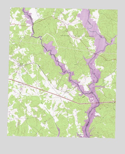
Buckhead, GA USGS Topographic Map
Click on map above to begin viewing in our Map Viewer.

This topographic map contains these locations and features:
Feature Name Type Latitude Longitude GNIS ID View Map
Apalachee RiverStreamN33.5443°W83.2782°354377View Map
Bird LakeReservoirN33.5395°W83.3074°338931View Map
Bird Lake DamDamN33.5385°W83.3066°338930View Map
BuckheadPopulated PlaceN33.5685°W83.3624°354900View Map
Buckhead Baptist ChurchChurchN33.5682°W83.3590°2674978View Map
Buckhead DivisionCivilN33.5329°W83.3584°1936142View Map
Buckhead Town OfficeBuildingN33.5733°W83.3667°2674979View Map
Buckhead Worship Center Congregational Holiness ChurchChurchN33.5658°W83.3581°2674977View Map
CareyPopulated PlaceN33.5476°W83.2690°354991View Map
Carey Station Hunt CampLocaleN33.5479°W83.2713°330662View Map
Cob CreekStreamN33.5462°W83.2790°348656View Map
Exit 52CrossingN33.5512°W83.3579°1705044View Map
Fork Chapel CemeteryCemeteryN33.6118°W83.3168°1705402View Map
Goose CreekStreamN33.5968°W83.3491°327971View Map
Greenville ChurchChurchN33.6148°W83.3243°328006View Map
Harmony Grove School (historical)SchoolN33.5868°W83.2990°348683View Map
Interchange Fifty-twoCrossingN33.5515°W83.3579°330663View Map
Jim Carey CemeteryCemeteryN33.5552°W83.2644°1705413View Map
Kingston School (historical)SchoolN33.5046°W83.3418°345995View Map
Massey LakeReservoirN33.5607°W83.3592°338929View Map
Massey Lake DamDamN33.5601°W83.3582°338928View Map
McCalls Hunt CampLocaleN33.5718°W83.2665°330664View Map
Moon Hunt CampLocaleN33.5532°W83.3054°330655View Map
Morgan County Fire Rescue Department Station 14BuildingN33.5213°W83.3190°2605010View Map
Morgan County Fire Rescue Department Station 15BuildingN33.5161°W83.3679°2605011View Map
Morgan County Fire Rescue Department Station 4BuildingN33.5708°W83.3643°2604529View Map
Moses ChapelChurchN33.5348°W83.2532°328850View Map
Mount Zion Baptist ChurchChurchN33.5149°W83.3293°328927View Map
Mount Zion Baptist Church CemeteryCemeteryN33.5152°W83.3291°2573953View Map
North Sugar CreekStreamN33.5487°W83.3716°329057View Map
Oconee ChurchChurchN33.5707°W83.2957°329084View Map
Parks Ferry (historical)CrossingN33.5040°W83.2835°346015View Map
Parks Ferry Recreational AreaLocaleN33.5151°W83.2710°330661View Map
Parks MillPopulated PlaceN33.5029°W83.2882°329135View Map
Perdue CemeteryCemeteryN33.5340°W83.2524°1705428View Map
Redlands Boat RampLocaleN33.5673°W83.2710°330665View Map
South Sugar CreekStreamN33.5487°W83.3716°329776View Map
Springfield ChurchChurchN33.6065°W83.3099°348722View Map
SwordsPopulated PlaceN33.5443°W83.3068°333175View Map
Swords Boat RampLocaleN33.5498°W83.3004°330654View Map
Taylor CemeteryCemeteryN33.5765°W83.3727°346029View Map
Town CreekStreamN33.5912°W83.2599°330033View Map
Town of BuckheadCivilN33.5685°W83.3623°2405340View Map
Whitaker CemeteryCemeteryN33.5973°W83.2982°1705444View Map

Note: Coordinates in the location and feature list above are referenced to NAD83 datum.


Copyright (C) 2008-2025 Ryan Niemi / Sunset Dynamics ... All Rights Reserved