TopoQuest Logo
Do you find TopoQuest useful?
Help keep TopoQuest running and adding new maps/features by donating!
Bitcoin:  19c7KJd3qBynnjoSw5npx9KScwjBe4ifkT
Litecoin:  LXs6TkuXGGXo1vDsWCkWVdjQX94eUKd6ui
Home View Maps Find Maps Find Places Resources & Links


Harmony, Georgia Topographic Map

USGS Map Title: Harmony, GA
USGS Map MRC: 33083D3
DRG (GeoTIFF) Download: o33083d3.tif


Neighboring USGS Topographic Map Quads:


  Madison, GA  
33083E4
 

  Buckhead, GA  
33083E3
 

  Greensboro, GA  
33083E2
 

  Rock Eagle Lake, GA  
33083D4
 

  Harmony, GA  
33083D3
 

  Liberty, GA  
33083D2
 

  Eatonton, GA  
33083C4
 

  Meda, GA  
33083C3
 

  Rockville, GA  
33083C2


Map MRC Location:

N34°
W84°
N34°
W83°
H8 H7 H6 H5 H4 H3 H2 H1
G8 G7 G6 G5 G4 G3 G2 G1
F8 F7 F6 F5 F4 F3 F2 F1
E8 E7 E6 E5 E4 E3 E2 E1
D8 D7 D6 D5 D4 D3 D2 D1
C8 C7 C6 C5 C4 C3 C2 C1
B8 B7 B6 B5 B4 B3 B2 B1
A8 A7 A6 A5 A4 A3 A2 A1
N33°
W84°
N33°
W83°

Harmony, GA USGS 1:24K Topographic Map Preview:
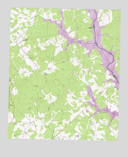
Harmony, GA USGS Topographic Map
Click on map above to begin viewing in our Map Viewer.

This topographic map contains these locations and features:
Feature Name Type Latitude Longitude GNIS ID View Map
Beall Pond Dam OneDamN33.3801°W83.2932°340579View Map
Beall Pond OneReservoirN33.3792°W83.2955°340580View Map
Clarks ForkStreamN33.4887°W83.3346°327463View Map
Dance BranchStreamN33.3824°W83.3421°327592View Map
Denham BranchStreamN33.4154°W83.3210°327630View Map
Dodson PondReservoirN33.3902°W83.3520°340578View Map
Dodson Pond DamDamN33.3901°W83.3516°340577View Map
Enterprise School (historical)SchoolN33.4937°W83.3463°345982View Map
Florence School (historical)SchoolN33.3976°W83.3682°347204View Map
Florence School (historical)SchoolN33.4271°W83.2729°347205View Map
Glade BranchStreamN33.4301°W83.2896°327938View Map
Glades Cross-RoadsPopulated PlaceN33.4660°W83.3160°347207View Map
HarmonyPopulated PlaceN33.4524°W83.3521°331916View Map
Harmony ChurchChurchN33.4365°W83.3354°347212View Map
Henderson Grove ChurchChurchN33.4068°W83.3704°328107View Map
Highlog BranchStreamN33.4154°W83.3210°328161View Map
Jacks ForkStreamN33.4687°W83.3057°328293View Map
JeffersonPopulated PlaceN33.4493°W83.3116°332092View Map
Jefferson ChurchChurchN33.4499°W83.3088°347221View Map
Jones Grove School (historical)SchoolN33.3787°W83.3143°347222View Map
Kraft LakeReservoirN33.4133°W83.2620°340075View Map
Kraft Lake DamDamN33.4135°W83.2615°340074View Map
Lake OconeeReservoirN33.4698°W83.3033°330982View Map
Lake Oconee ChapelChurchN33.4954°W83.3024°345996View Map
Little Sugar CreekStreamN33.4829°W83.3177°328580View Map
Lone Oak ChurchChurchN33.4201°W83.2696°328607View Map
New Bethel ChurchChurchN33.3907°W83.3616°328992View Map
Phoenix School (historical)SchoolN33.3785°W83.2774°347243View Map
Putnam - Morgan County Sugar Creek Fire Department Station 11BuildingN33.4778°W83.3010°2604631View Map
Putnam County Fire Rescue Department Station 3BuildingN33.4106°W83.2683°2604562View Map
Reeses LakeReservoirN33.4272°W83.2572°336447View Map
Reeses Lake DamDamN33.4268°W83.2549°336446View Map
Reids Ferry (historical)CrossingN33.4443°W83.2632°347254View Map
Rock Eagle Lake 4-H Club Roadside Park Picnic AreaParkN33.4182°W83.3732°330671View Map
RuddenPopulated PlaceN33.4385°W83.3335°332941View Map
Sebastian Cove AirportAirportN33.4541°W83.2782°2646217View Map
Spivey (historical)Populated PlaceN33.3996°W83.2743°347450View Map
Sugar CreekStreamN33.4676°W83.2782°329882View Map
Sugar Creek Boat RampLocaleN33.4710°W83.3124°330660View Map
Tanyard BranchStreamN33.3760°W83.3235°329929View Map
TurnwoldPopulated PlaceN33.3804°W83.2757°347264View Map
United States Department of Agriculture Forest Service Oconee Ranger DistrictBuildingN33.4138°W83.3728°2733994View Map
Walker LakeReservoirN33.3898°W83.3668°340073View Map
Walker Lake DamDamN33.3885°W83.3682°340072View Map
Ward ChapelChurchN33.3962°W83.2699°330160View Map
Weaver BranchStreamN33.4171°W83.3310°330185View Map

Note: Coordinates in the location and feature list above are referenced to NAD83 datum.


Copyright (C) 2008-2024 Ryan Niemi / Sunset Dynamics ... All Rights Reserved