TopoQuest Logo
Do you find TopoQuest useful?
Help keep TopoQuest running and adding new maps/features by donating!
Bitcoin:  19c7KJd3qBynnjoSw5npx9KScwjBe4ifkT
Litecoin:  LXs6TkuXGGXo1vDsWCkWVdjQX94eUKd6ui
Home View Maps Find Maps Find Places Resources & Links


Rodman, New York Topographic Map

USGS Map Title: Rodman, NY
USGS Map MRC: 43075G8
DRG (GeoTIFF) Download: o43075g8.tif


Neighboring USGS Topographic Map Quads:


  Sackets Harbor, NY  
43076H1
 

  Watertown, NY  
43075H8
 

  Rutland Center, NY  
43075H7
 

  Adams, NY  
43076G1
 

  Rodman, NY  
43075G8
 

  Barnes Corners, NY  
43075G7
 

  Sandy Creek, NY  
43076F1
 

  Boylston Center, NY  
43075F8
 

  Worth Center, NY  
43075F7


Map MRC Location:

N44°
W76°
N44°
W75°
H8 H7 H6 H5 H4 H3 H2 H1
G8 G7 G6 G5 G4 G3 G2 G1
F8 F7 F6 F5 F4 F3 F2 F1
E8 E7 E6 E5 E4 E3 E2 E1
D8 D7 D6 D5 D4 D3 D2 D1
C8 C7 C6 C5 C4 C3 C2 C1
B8 B7 B6 B5 B4 B3 B2 B1
A8 A7 A6 A5 A4 A3 A2 A1
N43°
W76°
N43°
W75°

Rodman, NY USGS 1:24K Topographic Map Preview:
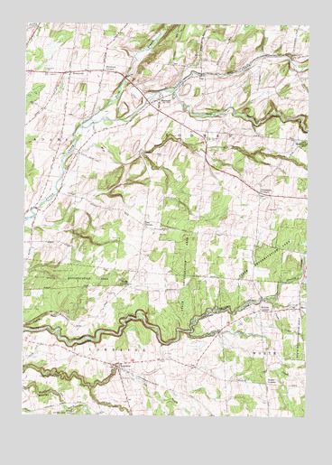
Rodman, NY USGS Topographic Map
Click on map above to begin viewing in our Map Viewer.

This topographic map contains these locations and features:
Feature Name Type Latitude Longitude GNIS ID View Map
Abijah CreekStreamN43.7770°W75.9271°942127View Map
Adams State Road CemeteryCemeteryN43.8599°W75.9916°953149View Map
Big BrookStreamN43.7584°W75.9696°969879View Map
Bullock CornersLocaleN43.7840°W75.8952°945162View Map
Clora CreekStreamN43.7859°W75.8894°946911View Map
Fairview CemeteryCemeteryN43.8385°W75.9185°949841View Map
Fish CreekStreamN43.8348°W75.9780°950134View Map
Gould CornersLocaleN43.7917°W75.9538°951416View Map
Grunley CreekStreamN43.7870°W75.8905°951881View Map
Gulf StreamStreamN43.8526°W75.9346°951922View Map
HoneyvillePopulated PlaceN43.8592°W75.9802°953148View Map
Honeyville Baptist ChurchChurchN43.8591°W75.9799°2616494View Map
Inman GulfValleyN43.8469°W75.9083°953733View Map
Isham CemeteryCemeteryN43.8524°W75.9347°953813View Map
Kings QuarryMineN43.8564°W75.9592°2516958View Map
LorrainePopulated PlaceN43.7665°W75.9594°955999View Map
Lorraine Census Designated PlaceCensusN43.7656°W75.9523°2584276View Map
Lorraine GulfValleyN43.7731°W75.9805°970321View Map
Lorraine Volunteer Fire CompanyBuildingN43.7664°W75.9532°2734733View Map
Lyman CemeteryCemeteryN43.7506°W75.9663°956169View Map
North Branch Sandy CreekStreamN43.8423°W75.9755°958719View Map
Porterdale FarmsLocaleN43.8325°W75.9761°2559250View Map
Randall CemeteryCemeteryN43.7580°W75.9995°962170View Map
RodmanPopulated PlaceN43.8512°W75.9408°962799View Map
Rodman Census Designated PlaceCensusN43.8512°W75.9406°2584288View Map
Rodman Fire DepartmentBuildingN43.8512°W75.9412°2718304View Map
Rodman Public LibraryBuildingN43.8495°W75.9413°2617404View Map
Ross CornersLocaleN43.8106°W75.9471°974251View Map
School Number 10 (historical)SchoolN43.8206°W75.8958°2353030View Map
School Number 11 (historical)SchoolN43.7653°W75.9239°2353031View Map
School Number 2 (historical)SchoolN43.7603°W75.8928°2353023View Map
School Number 3 (historical)SchoolN43.8611°W75.9228°2353024View Map
School Number 4 (historical)SchoolN43.8150°W75.9936°2353025View Map
School Number 4 (historical)SchoolN43.8639°W75.8839°2353026View Map
School Number 5 (historical)SchoolN43.7581°W75.9997°2095846View Map
School Number 6 (historical)SchoolN43.7947°W75.9247°2353027View Map
School Number 7 (historical)SchoolN43.8100°W75.9467°2353028View Map
School Number 8 (historical)SchoolN43.8342°W75.9203°2353029View Map
Stears CornersLocaleN43.7606°W75.8927°966317View Map
Thompson CemeteryCemeteryN43.8198°W75.9774°967405View Map
Towle GulfValleyN43.7787°W75.9994°967698View Map
Town of RodmanCivilN43.8419°W75.9104°979429View Map
Tremaines CornersLocaleN43.8215°W75.8960°967781View Map
Whitford CornersLocaleN43.8601°W75.9658°971171View Map
Worden Road BridgeBridgeN43.8565°W75.9307°2615006View Map
WorthPopulated PlaceN43.7842°W75.8777°973294View Map
ZoarPopulated PlaceN43.8587°W75.9224°973310View Map
Zoar CemeteryCemeteryN43.8635°W75.9220°971887View Map

Note: Coordinates in the location and feature list above are referenced to NAD83 datum.


Copyright (C) 2008-2025 Ryan Niemi / Sunset Dynamics ... All Rights Reserved