TopoQuest Logo
Do you find TopoQuest useful?
Help keep TopoQuest running and adding new maps/features by donating!
Bitcoin:  19c7KJd3qBynnjoSw5npx9KScwjBe4ifkT
Litecoin:  LXs6TkuXGGXo1vDsWCkWVdjQX94eUKd6ui
Home View Maps Find Maps Find Places Resources & Links


Rosiclare, Illinois Topographic Map

USGS Map Title: Rosiclare, IL
USGS Map MRC: 37088D3
DRG (GeoTIFF) Download: o37088d3.tif


Neighboring USGS Topographic Map Quads:


  Herod, IL  
37088E4
 

  Karbers Ridge, IL  
37088E3
 

  Saline Mines, IL  
37088E2
 

  Shetlerville, IL  
37088D4
 

  Rosiclare, IL  
37088D3
 

  Cave-in-Rock, IL  
37088D2
 

  Golconda, IL  
37088C4
 

  Lola, KY  
37088C3
 

  Salem, KY  
37088C2


Map MRC Location:

N38°
W89°
N38°
W88°
H8 H7 H6 H5 H4 H3 H2 H1
G8 G7 G6 G5 G4 G3 G2 G1
F8 F7 F6 F5 F4 F3 F2 F1
E8 E7 E6 E5 E4 E3 E2 E1
D8 D7 D6 D5 D4 D3 D2 D1
C8 C7 C6 C5 C4 C3 C2 C1
B8 B7 B6 B5 B4 B3 B2 B1
A8 A7 A6 A5 A4 A3 A2 A1
N37°
W89°
N37°
W88°

Rosiclare, IL USGS 1:24K Topographic Map Preview:
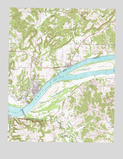
Rosiclare, IL USGS Topographic Map
Click on map above to begin viewing in our Map Viewer.

This topographic map contains these locations and features:
Feature Name Type Latitude Longitude GNIS ID View Map
Alcoa MineMineN37.4145°W88.3542°403383View Map
Argo Shaft Alcoa MineMineN37.4270°W88.3528°1955219View Map
Austin MineMineN37.4726°W88.3550°403745View Map
Barnett (historical)Populated PlaceN37.4264°W88.2811°2743660View Map
Barnett BranchStreamN37.4220°W88.3114°486391View Map
Barnett ChapelChurchN37.3998°W88.2950°486403View Map
Barnett LakeLakeN37.4203°W88.3163°486408View Map
Basset SchoolSchoolN37.4670°W88.2964°403957View Map
Bennett LakeLakeN37.4351°W88.2588°486861View Map
Big CreekStreamN37.4409°W88.3142°424640View Map
Buck CreekStreamN37.3978°W88.3675°511001View Map
Buzzards Roost Shaft Alcoa MineMineN37.4178°W88.3534°1955220View Map
Carmens Store (historical)LocaleN37.4584°W88.3473°1808759View Map
CarrsvillePopulated PlaceN37.3976°W88.3748°511234View Map
City of RosiclareCivilN37.4240°W88.3501°2396436View Map
Critchlow CemeteryCemeteryN37.4273°W88.3645°406794View Map
Daisy MineMineN37.4356°W88.3459°1955222View Map
Deer CreekStreamN37.4003°W88.3556°490770View Map
Dimmick MineMineN37.4417°W88.3450°1955223View Map
Dixon CemeteryCemeteryN37.4648°W88.3417°407252View Map
Dry ForkStreamN37.3847°W88.3049°491204View Map
Dubois MineMineN37.4542°W88.3736°407448View Map
East Rosiclare Election Precinct (historical)CivilN37.4373°W88.3348°1928488View Map
ElizabethtownPopulated PlaceN37.4459°W88.3050°407872View Map
Elizabethtown CemeteryCemeteryN37.4495°W88.3036°1820778View Map
Elizabethtown Fire DepartmentBuildingN37.4491°W88.3029°2682032View Map
Elizabethtown Post OfficePost OfficeN37.4467°W88.3047°2788470View Map
Elizabethtown Ranger StationLocaleN37.4545°W88.3017°424137View Map
Ellis MineMineN37.3959°W88.3528°491720View Map
Empire CemeteryCemeteryN37.4573°W88.3000°408018View Map
FairviewPopulated PlaceN37.4159°W88.3567°1808763View Map
Fairview Shaft Blue Diggings MineMineN37.4201°W88.3592°1955224View Map
Franklin BranchStreamN37.4378°W88.2725°492446View Map
Good Hope MineMineN37.4159°W88.3553°1955225View Map
Goose CreekStreamN37.4962°W88.3320°424937View Map
Hardin CemeteryCemeteryN37.3937°W88.3117°493720View Map
Hardin City SchoolSchoolN37.4709°W88.2914°424136View Map
Hardin County Ambulance ServiceBuildingN37.4199°W88.3449°2673892View Map
Hardin County General HospitalHospitalN37.4224°W88.3516°2662335View Map
Hardin County Sheriff's OfficeBuildingN37.4475°W88.3048°2759105View Map
Hillside MineMineN37.4359°W88.3434°1955226View Map
Hogthief CreekStreamN37.4914°W88.3300°425003View Map
Hosick CreekStreamN37.4531°W88.2834°410590View Map
Hurricane CreekStreamN37.4406°W88.2509°512865View Map
Hurricane IslandIslandN37.4459°W88.2706°512871View Map
Illinois Furnace Picnic AreaLocaleN37.4987°W88.3270°424130View Map
Indiana MinesMineN37.4581°W88.3728°1955228View Map
Iron Furnace Point of InterestLocaleN37.4973°W88.3370°424129View Map
Jacks Point Post LightBuildingN37.4333°W88.3167°2681031View Map
K and R MineMineN37.4703°W88.3586°411287View Map
Keeling HillSummitN37.4903°W88.2853°411341View Map
Keeling SchoolSchoolN37.4937°W88.2914°411342View Map
Lake TacumsehLakeN37.4830°W88.3257°424131View Map
Last Chance Shaft Blue Diggings MineMineN37.4237°W88.3542°1955231View Map
Lavender HillSummitN37.4423°W88.3689°411852View Map
Martin MineMineN37.4789°W88.3486°1955232View Map
McFarlan Election PrecinctCivilN37.4847°W88.2700°1928564View Map
MilfordPopulated PlaceN37.3890°W88.3116°2743695View Map
Milford BridgeBridgeN37.3887°W88.3136°498189View Map
Mineral City (historical)Populated PlaceN37.4095°W88.3534°1808779View Map
Mud LakeLakeN37.4115°W88.3343°498988View Map
New Ghelia Shaft Rosiclare MineMineN37.4295°W88.3467°1955233View Map
Number 1 Shaft Eureka MineMineN37.4501°W88.3386°1955234View Map
Number 6 Shaft Eureka MineMineN37.4470°W88.3411°1955235View Map
Ozark Mahoning MineMineN37.4306°W88.3431°415285View Map
Peters CreekStreamN37.4570°W88.2595°425325View Map
Preen MineMineN37.4659°W88.3725°1955237View Map
Price CemeteryCemeteryN37.4500°W88.3006°416208View Map
Recovery Shaft Rosiclare MineMineN37.4220°W88.3498°1955238View Map
RosiclarePopulated PlaceN37.4237°W88.3461°416968View Map
Rosiclare Election PrecinctCivilN37.4249°W88.3625°422243View Map
Rosiclare Fire DepartmentBuildingN37.4219°W88.3454°2682341View Map
Rosiclare MineMineN37.4264°W88.3520°416969View Map
Rosiclare MineMineN37.4364°W88.3459°416970View Map
Rosiclare Post OfficePost OfficeN37.4198°W88.3455°2788507View Map
Shephard CemeteryCemeteryN37.4167°W88.3695°418348View Map
South Boundary Shaft Rosiclare MineMineN37.4212°W88.3506°1955240View Map
Stewart ShaftMineN37.4520°W88.3370°1955241View Map
Stone ChurchChurchN37.4520°W88.3439°1808791View Map
Stone Church CemeteryCemeteryN37.4520°W88.3436°1820781View Map
Stone Church Election PrecinctCivilN37.4732°W88.3686°1928651View Map
Stone School (historical)SchoolN37.4512°W88.3448°1808792View Map
Susan CreekStreamN37.3828°W88.2984°504814View Map
Thompson CreekStreamN37.4251°W88.3039°505203View Map
Thrilkeld BranchStreamN37.3834°W88.3086°505259View Map
Village of ElizabethtownCivilN37.4499°W88.3051°2398801View Map
Wallace CemeteryCemeteryN37.4289°W88.2589°506139View Map
Watson BluffCliffN37.3926°W88.3370°506277View Map
West Rosiclare Election Precinct (historical)CivilN37.4239°W88.3664°1928677View Map
Whites ChapelChurchN37.3895°W88.2503°506669View Map
Whoopie Cat DamDamN37.4834°W88.3267°1690925View Map
Whoopie Cat LakeReservoirN37.4775°W88.3273°424135View Map
Whoopie Cat LakeReservoirN37.4830°W88.3257°1690926View Map

Note: Coordinates in the location and feature list above are referenced to NAD83 datum.


Copyright (C) 2008-2024 Ryan Niemi / Sunset Dynamics ... All Rights Reserved