TopoQuest Logo
Do you find TopoQuest useful?
Help keep TopoQuest running and adding new maps/features by donating!
Bitcoin:  19c7KJd3qBynnjoSw5npx9KScwjBe4ifkT
Litecoin:  LXs6TkuXGGXo1vDsWCkWVdjQX94eUKd6ui
Home View Maps Find Maps Find Places Resources & Links


Big Swamp, Mississippi Topographic Map

USGS Map Title: Big Swamp, MS
USGS Map MRC: 30089G4
DRG (GeoTIFF) Download: o30089g4.tif


Neighboring USGS Topographic Map Quads:


  Orvisburg, MS  
30089H5
 

  Hillsdale, MS  
30089H4
 

  Carnes, MS  
30089H3
 

  Poplarville, MS  
30089G5
 

  Big Swamp, MS  
30089G4
 

  Browns Lake, MS  
30089G3
 

  Millard, MS  
30089F5
 

  Savannah, MS  
30089F4
 

  Silver Run, MS  
30089F3


Map MRC Location:

N31°
W90°
N31°
W89°
H8 H7 H6 H5 H4 H3 H2 H1
G8 G7 G6 G5 G4 G3 G2 G1
F8 F7 F6 F5 F4 F3 F2 F1
E8 E7 E6 E5 E4 E3 E2 E1
D8 D7 D6 D5 D4 D3 D2 D1
C8 C7 C6 C5 C4 C3 C2 C1
B8 B7 B6 B5 B4 B3 B2 B1
A8 A7 A6 A5 A4 A3 A2 A1
N30°
W90°
N30°
W89°

Big Swamp, MS USGS 1:24K Topographic Map Preview:
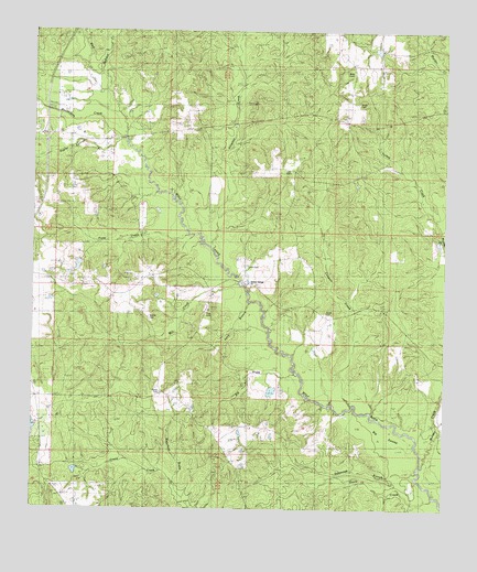
Big Swamp, MS USGS Topographic Map
Click on map above to begin viewing in our Map Viewer.

This topographic map contains these locations and features:
Feature Name Type Latitude Longitude GNIS ID View Map
Alligator CreekStreamN30.8182°W89.4451°692388View Map
Beall CemeteryCemeteryN30.8643°W89.4064°666774View Map
Beaverdam CreekStreamN30.8480°W89.4723°666730View Map
Big BrakeStreamN30.7866°W89.4214°667082View Map
Bilbo Lookout TowerTowerN30.7682°W89.4965°711204View Map
Bond CemeteryCemeteryN30.8566°W89.4037°667419View Map
Claude Gilheart Lake DamDamN30.8702°W89.3951°680530View Map
Cowpen CreekStreamN30.7766°W89.4028°668905View Map
Davis CreekStreamN30.7532°W89.3762°669139View Map
Frye CemeteryCemeteryN30.8005°W89.4484°670263View Map
Fryes CreekStreamN30.8219°W89.4528°670264View Map
Hickory Springs ChurchChurchN30.8080°W89.4337°671177View Map
Interchange 29CrossingN30.8480°W89.4965°691476View Map
Mill CreekStreamN30.8088°W89.4370°673590View Map
Mississippi Forestry Commission Pearl River County OfficeBuildingN30.7672°W89.4972°2668087View Map
Murder CreekStreamN30.7619°W89.3823°674468View Map
Murder CreekStreamN30.8266°W89.3776°694133View Map
Myrick CemeteryCemeteryN30.7999°W89.4648°690887View Map
Poplar Springs BranchStreamN30.8460°W89.4726°676234View Map
Progress SchoolSchoolN30.8102°W89.4345°676347View Map
Rester CemeteryCemeteryN30.7816°W89.4609°676609View Map
Savannah BranchStreamN30.7599°W89.3831°677435View Map
Sheldon CreekStreamN30.8638°W89.4806°694760View Map
Smith and Smith Ranch Lake DamDamN30.7802°W89.4284°680501View Map
Smith CemeteryCemeteryN30.8135°W89.4351°690895View Map
Smith CemeteryCemeteryN30.8030°W89.4109°677897View Map
Steephollow Volunteer Fire Department Station 3BuildingN30.8088°W89.4336°2332803View Map
Supervisor District 3CivilN30.7867°W89.4726°712023View Map
Waterhole BrakeStreamN30.7541°W89.4559°679366View Map
Wolf River Game Management AreaParkN30.8502°W89.4834°705358View Map

Note: Coordinates in the location and feature list above are referenced to NAD83 datum.


Copyright (C) 2008-2025 Ryan Niemi / Sunset Dynamics ... All Rights Reserved