TopoQuest Logo
Do you find TopoQuest useful?
Help keep TopoQuest running and adding new maps/features by donating!
Bitcoin:  19c7KJd3qBynnjoSw5npx9KScwjBe4ifkT
Litecoin:  LXs6TkuXGGXo1vDsWCkWVdjQX94eUKd6ui
Home View Maps Find Maps Find Places Resources & Links


Round Lake, Minnesota Topographic Map

USGS Map Title: Round Lake, MN
USGS Map MRC: 43095E4
DRG (GeoTIFF) Download: o43095e4.tif


Neighboring USGS Topographic Map Quads:


  Worthington North, MN  
43095F5
 

  Brewster, MN  
43095F4
 

  Okabena, MN  
43095F3
 

  Worthington South, MN  
43095E5
 

  Round Lake, MN  
43095E4
 

  Sioux Valley, MN  
43095E3
 

  Ocheyedan, IA  
43095D5
 

  Harris, IA  
43095D4
 

  Lake Park, IA  
43095D3


Map MRC Location:

N44°
W96°
N44°
W95°
H8 H7 H6 H5 H4 H3 H2 H1
G8 G7 G6 G5 G4 G3 G2 G1
F8 F7 F6 F5 F4 F3 F2 F1
E8 E7 E6 E5 E4 E3 E2 E1
D8 D7 D6 D5 D4 D3 D2 D1
C8 C7 C6 C5 C4 C3 C2 C1
B8 B7 B6 B5 B4 B3 B2 B1
A8 A7 A6 A5 A4 A3 A2 A1
N43°
W96°
N43°
W95°

Round Lake, MN USGS 1:24K Topographic Map Preview:
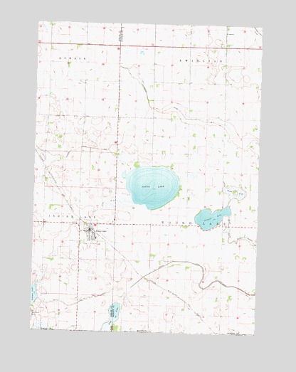
Round Lake, MN USGS Topographic Map
Click on map above to begin viewing in our Map Viewer.

This topographic map contains these locations and features:
Feature Name Type Latitude Longitude GNIS ID View Map
City of Round LakeCivilN43.5372°W95.4705°2396440View Map
County Ditch Number OneCanalN43.5136°W95.4681°641545View Map
County Ditch Number TenCanalN43.5525°W95.4583°641565View Map
Eastside Acres CampgroundLocaleN43.5405°W95.4683°2048977View Map
Grace CemeteryCemeteryN43.6222°W95.3947°2048795View Map
Grace ChurchChurchN43.6216°W95.3947°644296View Map
Illinois LakeLakeN43.5472°W95.4009°645340View Map
Iowa LakeLakeN43.5017°W95.4570°457830View Map
Iowa LakeReservoirN43.5114°W95.4514°645444View Map
Judicial Ditch Number NineCanalN43.5741°W95.4700°646001View Map
Judicial Ditch Number ThirteenCanalN43.5800°W95.3889°645806View Map
Judicial Ditch Number TwentyfourCanalN43.5211°W95.3944°645862View Map
KLES-FM (Worthington)TowerN43.5989°W95.4886°663362View Map
Plum LakeLakeN43.5575°W95.3881°649595View Map
Round LakeLakeN43.5594°W95.4343°650318View Map
Round LakePopulated PlaceN43.5405°W95.4683°650354View Map
Round Lake (historical)LocaleN43.5416°W95.4678°2048972View Map
Round Lake CemeteryCemeteryN43.5297°W95.4586°2049029View Map
Round Lake City HallBuildingN43.5416°W95.4689°2048975View Map
Round Lake Fire DepartmentBuildingN43.5405°W95.4689°2048976View Map
Round Lake Post OfficePost OfficeN43.5405°W95.4683°2048971View Map
Round Lake Presbyterian ChurchChurchN43.5397°W95.4667°2048974View Map
Round Lake Secondary SchoolSchoolN43.5375°W95.4650°2048973View Map
Township of Round LakeCivilN43.5437°W95.3948°665479View Map

Note: Coordinates in the location and feature list above are referenced to NAD83 datum.


Copyright (C) 2008-2024 Ryan Niemi / Sunset Dynamics ... All Rights Reserved