TopoQuest Logo
Do you find TopoQuest useful?
Help keep TopoQuest running and adding new maps/features by donating!
Bitcoin:  19c7KJd3qBynnjoSw5npx9KScwjBe4ifkT
Litecoin:  LXs6TkuXGGXo1vDsWCkWVdjQX94eUKd6ui
Home View Maps Find Maps Find Places Resources & Links


Ocheyedan, Iowa Topographic Map

USGS Map Title: Ocheyedan, IA
USGS Map MRC: 43095D5
DRG (GeoTIFF) Download: o43095d5.tif


Neighboring USGS Topographic Map Quads:


  Bigelow, MN  
43095E6
 

  Worthington South, MN  
43095E5
 

  Round Lake, MN  
43095E4
 

  Sibley East, IA  
43095D6
 

  Ocheyedan, IA  
43095D5
 

  Harris, IA  
43095D4
 

  Cloverdale, IA  
43095C6
 

  Melvin, IA  
43095C5
 

  May City, IA  
43095C4


Map MRC Location:

N44°
W96°
N44°
W95°
H8 H7 H6 H5 H4 H3 H2 H1
G8 G7 G6 G5 G4 G3 G2 G1
F8 F7 F6 F5 F4 F3 F2 F1
E8 E7 E6 E5 E4 E3 E2 E1
D8 D7 D6 D5 D4 D3 D2 D1
C8 C7 C6 C5 C4 C3 C2 C1
B8 B7 B6 B5 B4 B3 B2 B1
A8 A7 A6 A5 A4 A3 A2 A1
N43°
W96°
N43°
W95°

Ocheyedan, IA USGS 1:24K Topographic Map Preview:
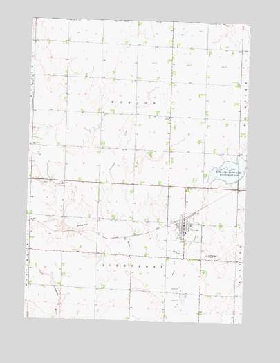
Ocheyedan, IA USGS Topographic Map
Click on map above to begin viewing in our Map Viewer.

This topographic map contains these locations and features:
Feature Name Type Latitude Longitude GNIS ID View Map
Christian Reformed ChurchChurchN43.4161°W95.5347°1907346View Map
City of OcheyedanCivilN43.4181°W95.5365°2395296View Map
Clear Lake Stock FarmsLocaleN43.4039°W95.5961°2723243View Map
Cooperative ElevatorLocaleN43.4161°W95.5347°1907352View Map
D T K FarmsLocaleN43.4167°W95.5233°2723230View Map
Devils Ridge Wildlife AreaParkN43.4416°W95.5697°1907358View Map
Ely-Bauermeister Wildlife Management AreaParkN43.4166°W95.6031°1907359View Map
Horton Township CemeteryCemeteryN43.4433°W95.5439°1907356View Map
Horton Township Cemetery Prairie PreserveParkN43.4416°W95.5453°1907357View Map
Keller Wildlife AreaParkN43.3889°W95.5642°1907367View Map
Loof Wildlife Management AreaParkN43.4480°W95.6245°1907363View Map
Margae FarmsLocaleN43.3892°W95.5603°2723232View Map
Methodist ChurchChurchN43.4161°W95.5347°1907347View Map
Meyer Dairy FarmLocaleN43.3858°W95.5658°2723237View Map
OcheyedanPopulated PlaceN43.4161°W95.5347°459794View Map
OcheyedanLocaleN43.4186°W95.5328°1907355View Map
Ocheyedan 'Y' Rest AreaLocaleN43.4305°W95.5336°1907369View Map
Ocheyedan Christian SchoolSchoolN43.4158°W95.5397°1907353View Map
Ocheyedan Community SchoolSchoolN43.4125°W95.5339°1907354View Map
Ocheyedan Fire DepartmentBuildingN43.4163°W95.5344°2577334View Map
Ocheyedan MoundSummitN43.4027°W95.5211°459795View Map
Ocheyedan Mound Wildlife AreaParkN43.4027°W95.5197°1907371View Map
Ocheyedan Pits Recreation AreaParkN43.3861°W95.5331°1907372View Map
Ocheyedan Post OfficePost OfficeN43.4161°W95.5347°1907351View Map
Ocheyedan Post Office (historical)Post OfficeN43.4308°W95.5495°466412View Map
Ocheyedan Public LibraryBuildingN43.4161°W95.5347°1907349View Map
Ocheyedan Township CemeteryCemeteryN43.4125°W95.5436°1907276View Map
Ocheyedan Well Wildlife AreaParkN43.4014°W95.5636°1907370View Map
Osceola CountyCivilN43.3786°W95.6237°465260View Map
Osceola County Ambulance Service Ocheyedan DivisionBuildingN43.4163°W95.5344°2599835View Map
Osceola County Waterfowl Production AreaParkN43.4939°W95.5395°2776746View Map
Osterman CreekStreamN43.4119°W95.5767°459914View Map
Randall FarmLocaleN43.4325°W95.5594°2723234View Map
Rush LakeLakeN43.4383°W95.5092°463778View Map
Rush Lake State Game Management AreaParkN43.4375°W95.5100°460858View Map
Saint John Lutheran ChurchChurchN43.4161°W95.5347°1907348View Map
Saint Peter Lutheran ChurchChurchN43.4144°W95.5381°1907350View Map
Sunrise Pullet Farm Number 1LocaleN43.3878°W95.5236°2723240View Map
Sunrise Pullet Farm Number 2LocaleN43.4167°W95.5900°2723239View Map
Sutton Lake MarshSwampN43.4039°W95.5133°1907364View Map
Swalve Wildlife Management AreaParkN43.4158°W95.5464°1907365View Map
Township of HortonCivilN43.4659°W95.5637°468053View Map
Township of OcheyedanCivilN43.3880°W95.5640°468459View Map
Travaille Family FarmsLocaleN43.4558°W95.5614°2723238View Map
Van Diepen FarmsLocaleN43.3933°W95.6028°2723241View Map
Willow Creek County Recreation AreaParkN43.4319°W95.6058°1907361View Map
Willow Creek Fen - Wetlands AreaParkN43.4339°W95.6225°1907362View Map
Wilson Pit Wildlife AreaParkN43.4016°W95.5656°1907366View Map
Wolters PrairieAreaN43.4166°W95.6058°1907360View Map
Zion Evangelical Lutheran CemeteryCemeteryN43.4600°W95.5461°1907275View Map
Zion Lutheran ChurchChurchN43.4605°W95.5450°1907373View Map
Zion SchoolSchoolN43.4602°W95.5450°463283View Map

Note: Coordinates in the location and feature list above are referenced to NAD83 datum.


Copyright (C) 2008-2024 Ryan Niemi / Sunset Dynamics ... All Rights Reserved