TopoQuest Logo
Do you find TopoQuest useful?
Help keep TopoQuest running and adding new maps/features by donating!
Bitcoin:  19c7KJd3qBynnjoSw5npx9KScwjBe4ifkT
Litecoin:  LXs6TkuXGGXo1vDsWCkWVdjQX94eUKd6ui
Home View Maps Find Maps Find Places Resources & Links


Worthington South, Minnesota Topographic Map

USGS Map Title: Worthington South, MN
USGS Map MRC: 43095E5
DRG (GeoTIFF) Download: o43095e5.tif


Neighboring USGS Topographic Map Quads:


  Reading, MN  
43095F6
 

  Worthington North, MN  
43095F5
 

  Brewster, MN  
43095F4
 

  Bigelow, MN  
43095E6
 

  Worthington South, MN  
43095E5
 

  Round Lake, MN  
43095E4
 

  Sibley East, IA  
43095D6
 

  Ocheyedan, IA  
43095D5
 

  Harris, IA  
43095D4


Map MRC Location:

N44°
W96°
N44°
W95°
H8 H7 H6 H5 H4 H3 H2 H1
G8 G7 G6 G5 G4 G3 G2 G1
F8 F7 F6 F5 F4 F3 F2 F1
E8 E7 E6 E5 E4 E3 E2 E1
D8 D7 D6 D5 D4 D3 D2 D1
C8 C7 C6 C5 C4 C3 C2 C1
B8 B7 B6 B5 B4 B3 B2 B1
A8 A7 A6 A5 A4 A3 A2 A1
N43°
W96°
N43°
W95°

Worthington South, MN USGS 1:24K Topographic Map Preview:
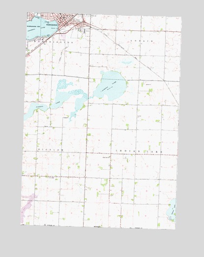
Worthington South, MN USGS Topographic Map
Click on map above to begin viewing in our Map Viewer.

This topographic map contains these locations and features:
Feature Name Type Latitude Longitude GNIS ID View Map
Buss FieldParkN43.6161°W95.5920°2048929View Map
Calvary Baptist ChurchChurchN43.6239°W95.5925°2048893View Map
Centennial ParkParkN43.6236°W95.6153°641042View Map
Central Elementary SchoolSchoolN43.6225°W95.5950°2048919View Map
Chatauqua ParkParkN43.6205°W95.6078°641132View Map
Christian Reformed ChurchChurchN43.6191°W95.5933°2048889View Map
Church ParkParkN43.6236°W95.5906°2048938View Map
Ehlers ParkParkN43.6139°W95.6031°2048934View Map
Emmanuel United Methodist ChurchChurchN43.6233°W95.5922°2048894View Map
First Baptist ChurchChurchN43.6089°W95.6128°2048900View Map
First Covenant ChurchChurchN43.6086°W95.6183°2048901View Map
First Lutheran ChurchChurchN43.6219°W95.5945°2048891View Map
First United Methodist ChurchChurchN43.6216°W95.5961°2048899View Map
Freedom ParkParkN43.6105°W95.6128°2048936View Map
Grace Community ChurchChurchN43.6041°W95.6245°2048903View Map
Grace Lutheran ChurchChurchN43.6200°W95.5964°2048906View Map
Hawkeye County ParkParkN43.5083°W95.5089°2048978View Map
Hogans ParkParkN43.6180°W95.5839°2048928View Map
Indian LakeLakeN43.5122°W95.5022°645415View Map
Indian Lake Baptist CemeteryCemeteryN43.5416°W95.5544°2049020View Map
Indian Lake ChurchChurchN43.5411°W95.5545°645416View Map
James Willey State Wildlife Management AreaParkN43.5611°W95.5836°2048848View Map
John Erickson State Wildlife Management AreaParkN43.5472°W95.6114°2048846View Map
Lake BellaReservoirN43.5014°W95.6245°639883View Map
Lake Bella State Wildlife Management AreaParkN43.5055°W95.6170°2048844View Map
Lake Front ParkParkN43.6194°W95.6003°2048935View Map
Lake Ocheda Game RefugeParkN43.5750°W95.5670°2048847View Map
Leota Police DeptBuildingN43.6190°W95.5979°2758563View Map
Ludlow ParkParkN43.6105°W95.6075°647282View Map
Nobles County CourthouseBuildingN43.6194°W95.5975°2048924View Map
Nobles County LibraryBuildingN43.6222°W95.5931°2048916View Map
Nystrom OrchardLocaleN43.5483°W95.5961°2647725View Map
Ocheda OrchardLocaleN43.5636°W95.5708°2647726View Map
Okabena LakeReservoirN43.6161°W95.5995°648911View Map
Okabena Lake DamDamN43.6233°W95.6170°1776067View Map
Orchard Knoll ParkParkN43.6158°W95.5789°2048926View Map
Pleasant ParkParkN43.6069°W95.6175°2048946View Map
Prairie Elementary SchoolSchoolN43.6041°W95.6183°2048920View Map
Saint Mary's ChurchChurchN43.6244°W95.5978°2048896View Map
Saint Mary's ConventChurchN43.6247°W95.5975°2048897View Map
Saint Mary's SchoolSchoolN43.6247°W95.5981°2048921View Map
Saint Marys CemeteryCemeteryN43.6242°W95.5741°650838View Map
Sanford Worthington Medical CenterHospitalN43.6222°W95.5982°2048885View Map
South East Side ParkParkN43.6180°W95.5767°2048927View Map
South Shore Care CenterHospitalN43.6105°W95.6120°2048884View Map
Sportsman County ParkParkN43.5814°W95.5822°2048843View Map
Stateline Structure DamDamN43.5014°W95.6245°1776441View Map
The Church of Jesus Christ of Latter Day SaintsChurchN43.6233°W95.5953°2048895View Map
Township of Indian LakeCivilN43.5436°W95.5155°664544View Map
Vietnamese Christian Reformed ChurchChurchN43.6191°W95.5936°2048890View Map
Wachter State Wildlife Management AreaParkN43.5333°W95.6025°2048845View Map
WorthingtonPopulated PlaceN43.6200°W95.5964°654391View Map
WorthingtonLocaleN43.6194°W95.5920°2048883View Map
Worthington City HallBuildingN43.6191°W95.5975°2048881View Map
Worthington Fire DepartmentBuildingN43.6177°W95.5962°2048880View Map
Worthington Post OfficePost OfficeN43.6236°W95.6006°2048879View Map
Worthington Specialty ClinicsHospitalN43.6211°W95.5995°2048886View Map
Worthington Township CemeteryCemeteryN43.6152°W95.5753°2049024View Map

Note: Coordinates in the location and feature list above are referenced to NAD83 datum.


Copyright (C) 2008-2024 Ryan Niemi / Sunset Dynamics ... All Rights Reserved