TopoQuest Logo
Do you find TopoQuest useful?
Help keep TopoQuest running and adding new maps/features by donating!
Bitcoin:  19c7KJd3qBynnjoSw5npx9KScwjBe4ifkT
Litecoin:  LXs6TkuXGGXo1vDsWCkWVdjQX94eUKd6ui
Home View Maps Find Maps Find Places Resources & Links


Round Top Mountain, Arizona Topographic Map

USGS Map Title: Round Top Mountain, AZ
USGS Map MRC: 33110H1
DRG (GeoTIFF) Download: o33110h1.tif


Neighboring USGS Topographic Map Quads:


  Long Tom Canyon, AZ  
34110A2
 

  Faught Ridge, AZ  
34110A1
 

  Indian Pine, AZ  
34109A8
 

  Cedar Creek, AZ  
33110H2
 

  Round Top Mountain, AZ  
33110H1
 

  Alchesay Flat, AZ  
33109H8
 

  Cone Butte, AZ  
33110G2
 

  Canyon Day, AZ  
33110G1
 

  Whiteriver, AZ  
33109G8


Map MRC Location:

N34°
W111°
N34°
W110°
H8 H7 H6 H5 H4 H3 H2 H1
G8 G7 G6 G5 G4 G3 G2 G1
F8 F7 F6 F5 F4 F3 F2 F1
E8 E7 E6 E5 E4 E3 E2 E1
D8 D7 D6 D5 D4 D3 D2 D1
C8 C7 C6 C5 C4 C3 C2 C1
B8 B7 B6 B5 B4 B3 B2 B1
A8 A7 A6 A5 A4 A3 A2 A1
N33°
W111°
N33°
W110°

Round Top Mountain, AZ USGS 1:24K Topographic Map Preview:
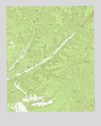
Round Top Mountain, AZ USGS Topographic Map
Click on map above to begin viewing in our Map Viewer.

This topographic map contains these locations and features:
Feature Name Type Latitude Longitude GNIS ID View Map
A-eightyone TankReservoirN33.9044°W110.0493°464View Map
Banana SpringSpringN33.8817°W110.0057°991View Map
Bear SpringSpringN33.9857°W110.0804°1141View Map
Bear TankReservoirN33.9886°W110.0482°1151View Map
Big Canyon Tank Number OneReservoirN33.9398°W110.0673°1298View Map
Big Canyon Tank Number TwoReservoirN33.9275°W110.0922°1299View Map
Bull TankReservoirN33.8991°W110.0272°2175View Map
C-Dart SpringSpringN33.9996°W110.0227°2329View Map
Cowboy SpringSpringN33.9902°W110.0235°3463View Map
Coyote TankReservoirN33.8862°W110.0228°3512View Map
Cub SpringsSpringN33.9784°W110.0643°3633View Map
Deer Spring CreekStreamN33.9767°W110.0245°28393View Map
Deer TankReservoirN33.9135°W110.0415°3819View Map
Eightyfive Bar SpringSpringN33.9499°W110.0131°14148View Map
Fir SpringSpringN33.9009°W110.0945°4604View Map
G-five Farm SpringSpringN33.8875°W110.0790°4890View Map
G-five Farm TankReservoirN33.8902°W110.0644°4891View Map
G-five TankReservoirN33.8880°W110.0565°4892View Map
Horse Pasture TankReservoirN33.9550°W110.1187°5980View Map
I-nineteen SpringsSpringN33.9483°W110.0961°6162View Map
I-nineteen TankReservoirN33.9464°W110.0989°6163View Map
Pine TankReservoirN33.8808°W110.0757°9486View Map
R-seven SpringSpringN33.9150°W110.1155°9888View Map
Red Willow SpringSpringN33.9759°W110.0192°10177View Map
Round Top MountainSummitN33.9334°W110.0101°10546View Map
Round Top Mountain LookoutTowerN33.9334°W110.0098°22363View Map
Steer Pasture SpringSpringN33.8986°W110.1198°11819View Map
Upper Walnut SpringSpringN33.9945°W110.0841°13131View Map
Walker TankReservoirN33.9509°W110.0536°13295View Map
Walnut SpringSpringN33.9819°W110.0867°13324View Map

Note: Coordinates in the location and feature list above are referenced to NAD83 datum.


Copyright (C) 2008-2025 Ryan Niemi / Sunset Dynamics ... All Rights Reserved