TopoQuest Logo
Do you find TopoQuest useful?
Help keep TopoQuest running and adding new maps/features by donating!
Bitcoin:  19c7KJd3qBynnjoSw5npx9KScwjBe4ifkT
Litecoin:  LXs6TkuXGGXo1vDsWCkWVdjQX94eUKd6ui
Home View Maps Find Maps Find Places Resources & Links


Brandsville, Missouri Topographic Map

USGS Map Title: Brandsville, MO
USGS Map MRC: 36091F6
DRG (GeoTIFF) Download: o36091f6.tif


Neighboring USGS Topographic Map Quads:


  White Church, MO  
36091G7
 

  Peace Valley, MO  
36091G6
 

  Thomasville, MO  
36091G5
 

  West Plains, MO  
36091F7
 

  Brandsville, MO  
36091F6
 

  Rover, MO  
36091F5
 

  Lanton, MO  
36091E7
 

  Koshkonong, MO  
36091E6
 

  Thayer, MO  
36091E5


Map MRC Location:

N37°
W92°
N37°
W91°
H8 H7 H6 H5 H4 H3 H2 H1
G8 G7 G6 G5 G4 G3 G2 G1
F8 F7 F6 F5 F4 F3 F2 F1
E8 E7 E6 E5 E4 E3 E2 E1
D8 D7 D6 D5 D4 D3 D2 D1
C8 C7 C6 C5 C4 C3 C2 C1
B8 B7 B6 B5 B4 B3 B2 B1
A8 A7 A6 A5 A4 A3 A2 A1
N36°
W92°
N36°
W91°

Brandsville, MO USGS 1:24K Topographic Map Preview:
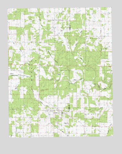
Brandsville, MO USGS Topographic Map
Click on map above to begin viewing in our Map Viewer.

This topographic map contains these locations and features:
Feature Name Type Latitude Longitude GNIS ID View Map
Adams School (historical)SchoolN36.6764°W91.7324°713148View Map
Big Apple SchoolSchoolN36.6645°W91.6490°714127View Map
BrandsvillePopulated PlaceN36.6503°W91.6901°735527View Map
Brandsville Fire Protection AssociationBuildingN36.6512°W91.6982°2620932View Map
Brandsville Post OfficePost OfficeN36.6508°W91.6980°2782993View Map
City of BrandsvilleCivilN36.6507°W91.6965°2394241View Map
CullPopulated PlaceN36.7273°W91.6843°740786View Map
Cull Post Office (historical)Post OfficeN36.7273°W91.6843°1802606View Map
Elk CreekStreamN36.6759°W91.6490°717452View Map
Elk Creek CemeteryCemeteryN36.7449°W91.6924°2702331View Map
Elk Creek ChurchChurchN36.7452°W91.6928°717455View Map
Elk Creek School (historical)SchoolN36.7306°W91.6965°717456View Map
Francis CemeteryCemeteryN36.7301°W91.6790°735133View Map
Garretts BranchStreamN36.6826°W91.6779°760062View Map
Harbeston SinkBasinN36.6377°W91.6791°719079View Map
Howell ValleyValleyN36.6864°W91.7326°719934View Map
Hunter CrossingPopulated PlaceN36.6787°W91.6674°740950View Map
New Attie SchoolSchoolN36.7214°W91.6488°723178View Map
Omrie Sinclair DamDamN36.7334°W91.6851°764762View Map
Pocohontas CrossingPopulated PlaceN36.6853°W91.6868°741164View Map
Rattlesnake BranchStreamN36.6881°W91.6874°735132View Map
Rattlesnake HollowValleyN36.6884°W91.6882°725118View Map
Rover BranchStreamN36.7089°W91.6365°725635View Map
Summers School (historical)SchoolN36.7159°W91.7404°727289View Map
Turkey CreekStreamN36.6934°W91.6593°727844View Map
Union Hill ChurchChurchN36.6365°W91.7415°728019View Map
Victory Mission ChurchChurchN36.7378°W91.6849°728191View Map
Water BranchStreamN36.7017°W91.6657°728392View Map

Note: Coordinates in the location and feature list above are referenced to NAD83 datum.


Copyright (C) 2008-2025 Ryan Niemi / Sunset Dynamics ... All Rights Reserved