TopoQuest Logo
Do you find TopoQuest useful?
Help keep TopoQuest running and adding new maps/features by donating!
Bitcoin:  19c7KJd3qBynnjoSw5npx9KScwjBe4ifkT
Litecoin:  LXs6TkuXGGXo1vDsWCkWVdjQX94eUKd6ui
Home View Maps Find Maps Find Places Resources & Links


Rockwell, North Carolina Topographic Map

USGS Map Title: Rockwell, NC
USGS Map MRC: 35080E4
DRG (GeoTIFF) Download: o35080e4.tif


Neighboring USGS Topographic Map Quads:


  Rowan Mills, NC  
35080F5
 

  Salisbury, NC  
35080F4
 

  Southmont, NC  
35080F3
 

  China Grove, NC  
35080E5
 

  Rockwell, NC  
35080E4
 

  Gold Hill, NC  
35080E3
 

  Concord, NC  
35080D5
 

  Mount Pleasant, NC  
35080D4
 

  Richfield, NC  
35080D3


Map MRC Location:

N36°
W81°
N36°
W80°
H8 H7 H6 H5 H4 H3 H2 H1
G8 G7 G6 G5 G4 G3 G2 G1
F8 F7 F6 F5 F4 F3 F2 F1
E8 E7 E6 E5 E4 E3 E2 E1
D8 D7 D6 D5 D4 D3 D2 D1
C8 C7 C6 C5 C4 C3 C2 C1
B8 B7 B6 B5 B4 B3 B2 B1
A8 A7 A6 A5 A4 A3 A2 A1
N35°
W81°
N35°
W80°

Rockwell, NC USGS 1:24K Topographic Map Preview:
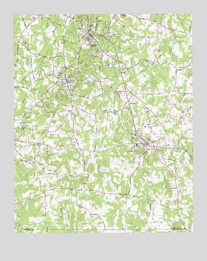
Rockwell, NC USGS Topographic Map
Click on map above to begin viewing in our Map Viewer.

This topographic map contains these locations and features:
Feature Name Type Latitude Longitude GNIS ID View Map
Antioch CemeteryCemeteryN35.6165°W80.4342°980205View Map
Canaan ChurchChurchN35.6213°W80.4567°982573View Map
Christiana CemeteryCemeteryN35.5974°W80.4267°983178View Map
Concorice ChurchChurchN35.5210°W80.4167°983445View Map
Correll ParkPopulated PlaceN35.6026°W80.4992°1001815View Map
CrescentPopulated PlaceN35.5754°W80.4201°1019855View Map
East Rowan High SchoolSchoolN35.5935°W80.4237°984533View Map
Eastside ChurchChurchN35.5943°W80.3801°984568View Map
Emmanuel ChurchChurchN35.5260°W80.3867°984775View Map
Erwin Junior High SchoolSchoolN35.5957°W80.4228°1001831View Map
FaithPopulated PlaceN35.5871°W80.4628°1020206View Map
Faith Elementary SchoolSchoolN35.5949°W80.4628°1001833View Map
Faith Fire DepartmentBuildingN35.5877°W80.4635°2638199View Map
Faith Post OfficePost OfficeN35.5879°W80.4607°2774200View Map
Four Square ChurchChurchN35.5468°W80.4153°985339View Map
Garfield (historical)Populated PlaceN35.5460°W80.3787°1001839View Map
Grace-Lower Stone ChurchChurchN35.5210°W80.4214°985903View Map
Granite LakeReservoirN35.6193°W80.4469°985921View Map
Granite QuarryPopulated PlaceN35.6124°W80.4467°985922View Map
Granite Quarry Elementary SchoolSchoolN35.6104°W80.4478°1001841View Map
Granite Quarry Fire DepartmentBuildingN35.6145°W80.4474°2638740View Map
Granite Quarry Post OfficePost OfficeN35.6141°W80.4450°2773826View Map
Happys LakeReservoirN35.5602°W80.4957°986381View Map
Herman QuarryMineN35.6039°W80.4425°2649044View Map
Kluns CreekStreamN35.5374°W80.3948°1001857View Map
Lyerly ChurchChurchN35.5696°W80.4356°989139View Map
North Barringer (historical)Populated PlaceN35.5476°W80.4523°1001884View Map
Old Stone HouseLocaleN35.6213°W80.4417°991613View Map
Organ ChurchChurchN35.5285°W80.4503°991688View Map
Pink Star QuarryMineN35.5406°W80.4664°2649268View Map
Rendleman (historical)Populated PlaceN35.5824°W80.3895°1001900View Map
Rock Grove ChurchChurchN35.5413°W80.4915°993504View Map
RockwellPopulated PlaceN35.5513°W80.4064°993551View Map
Rockwell City Fire DepartmentBuildingN35.5526°W80.4098°2639804View Map
Rockwell Elementary SchoolSchoolN35.5560°W80.4148°1001902View Map
Rockwell Police DepartmentBuildingN35.5529°W80.4092°2769631View Map
Rockwell Post OfficePost OfficeN35.5513°W80.4062°2774276View Map
Rockwell Rural Volunteer Fire Department Station 71BuildingN35.5535°W80.4179°2639676View Map
Rowan County Emergency ServicesBuildingN35.6243°W80.4825°2720561View Map
Saint Lukes ChurchChurchN35.5974°W80.4017°993994View Map
Saint Pauls ChurchChurchN35.6085°W80.4917°994088View Map
Shiloh CemeteryCemeteryN35.6246°W80.4626°994680View Map
Shiloh ChurchChurchN35.5868°W80.4626°994696View Map
Shupings MillPopulated PlaceN35.5515°W80.4815°994783View Map
South Salisbury Volunteer Fire Department Station 74BuildingN35.6190°W80.4897°2639672View Map
TimbercreekPopulated PlaceN35.6143°W80.4164°1001924View Map
Town of FaithCivilN35.5901°W80.4581°2406483View Map
Town of Granite QuarryCivilN35.6126°W80.4485°2406602View Map
Town of RockwellCivilN35.5539°W80.4071°2407232View Map
Township of Gold HillCivilN35.5409°W80.4105°1027145View Map
Township of LitakerCivilN35.5704°W80.4968°1027146View Map
West Park ChurchChurchN35.5438°W80.4434°997034View Map
White Rock ChurchChurchN35.6135°W80.4303°997206View Map
Wittenberg CemeteryCemeteryN35.6171°W80.4520°997514View Map

Note: Coordinates in the location and feature list above are referenced to NAD83 datum.


Copyright (C) 2008-2025 Ryan Niemi / Sunset Dynamics ... All Rights Reserved