TopoQuest Logo
Do you find TopoQuest useful?
Help keep TopoQuest running and adding new maps/features by donating!
Bitcoin:  19c7KJd3qBynnjoSw5npx9KScwjBe4ifkT
Litecoin:  LXs6TkuXGGXo1vDsWCkWVdjQX94eUKd6ui
Home View Maps Find Maps Find Places Resources & Links


Cool Springs, North Carolina Topographic Map

USGS Map Title: Cool Springs, NC
USGS Map MRC: 35080G6
DRG (GeoTIFF) Download: o35080g6.tif


Neighboring USGS Topographic Map Quads:


  Harmony, NC  
35080H7
 

  Calahaln, NC  
35080H6
 

  Mocksville, NC  
35080H5
 

  Statesville East, NC  
35080G7
 

  Cool Springs, NC  
35080G6
 

  Cooleemee, NC  
35080G5
 

  Shepherds, NC  
35080F7
 

  Cleveland, NC  
35080F6
 

  Rowan Mills, NC  
35080F5


Map MRC Location:

N36°
W81°
N36°
W80°
H8 H7 H6 H5 H4 H3 H2 H1
G8 G7 G6 G5 G4 G3 G2 G1
F8 F7 F6 F5 F4 F3 F2 F1
E8 E7 E6 E5 E4 E3 E2 E1
D8 D7 D6 D5 D4 D3 D2 D1
C8 C7 C6 C5 C4 C3 C2 C1
B8 B7 B6 B5 B4 B3 B2 B1
A8 A7 A6 A5 A4 A3 A2 A1
N35°
W81°
N35°
W80°

Cool Springs, NC USGS 1:24K Topographic Map Preview:
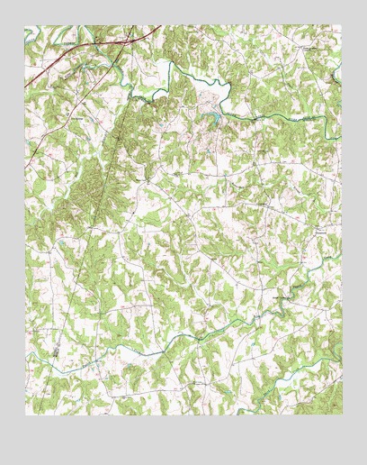
Cool Springs, NC USGS Topographic Map
Click on map above to begin viewing in our Map Viewer.

This topographic map contains these locations and features:
Feature Name Type Latitude Longitude GNIS ID View Map
Bell BranchStreamN35.8529°W80.7076°980930View Map
Byerlys Chapel MethodistChurchN35.8587°W80.6292°1008074View Map
Cleveland Community Volunteer Fire Department Station 35BuildingN35.7563°W80.7084°2638301View Map
Cool Spring SchoolSchoolN35.8460°W80.7323°1001711View Map
Cool SpringsPopulated PlaceN35.8449°W80.7326°1019768View Map
Cool Springs Volunteer Fire Department Station 2BuildingN35.8318°W80.7499°2639114View Map
Davie Academy CornersLocaleN35.8679°W80.6406°983979View Map
Dusty Road Jersey FarmLocaleN35.8639°W80.7306°2633195View Map
Fifth CreekStreamN35.8626°W80.7156°1020240View Map
Flying S Ranch AirportAirportN35.7579°W80.7347°2679141View Map
Knox Grove ChurchChurchN35.7557°W80.7115°988059View Map
Little CreekStreamN35.8451°W80.6365°988610View Map
Moores ChapelChurchN35.8254°W80.7015°990194View Map
Mount VernonPopulated PlaceN35.7876°W80.6467°1006304View Map
NeedmorePopulated PlaceN35.8096°W80.6348°990894View Map
New Jerusalem ChurchChurchN35.8171°W80.6542°991051View Map
PittsburgPopulated PlaceN35.8251°W80.7003°1001896View Map
Providence ChurchChurchN35.8271°W80.6915°992878View Map
Rowan - Iredell Volunteer Fire DepartmentBuildingN35.8111°W80.7094°1007811View Map
Scotch - Irish Volunteer Fire Department Station 73BuildingN35.8112°W80.6294°2638379View Map
Scotch-Irish Plantation LakeReservoirN35.8435°W80.6753°999567View Map
Scotch-Irish Plantation Lake DamDamN35.8451°W80.6731°999566View Map
Shaws BridgeBridgeN35.8385°W80.6273°1008073View Map
South River ChurchChurchN35.8346°W80.6545°995206View Map
Strouds Store siteLocaleN35.8737°W80.6503°1008072View Map
Third Creek ChurchChurchN35.7601°W80.6840°996022View Map
Township of Scotch IrishCivilN35.8069°W80.6681°1027152View Map
Unity (historical)Populated PlaceN35.7599°W80.6462°1001927View Map

Note: Coordinates in the location and feature list above are referenced to NAD83 datum.


Copyright (C) 2008-2024 Ryan Niemi / Sunset Dynamics ... All Rights Reserved