TopoQuest Logo
Do you find TopoQuest useful?
Help keep TopoQuest running and adding new maps/features by donating!
Bitcoin:  19c7KJd3qBynnjoSw5npx9KScwjBe4ifkT
Litecoin:  LXs6TkuXGGXo1vDsWCkWVdjQX94eUKd6ui
Home View Maps Find Maps Find Places Resources & Links


Rowlesburg, West Virginia Topographic Map

USGS Map Title: Rowlesburg, WV
USGS Map MRC: 39079C6
DRG (GeoTIFF) Download: o39079c6.tif


Neighboring USGS Topographic Map Quads:


  Newburg, WV  
39079D7
 

  Kingwood, WV  
39079D6
 

  Terra Alta, WV  
39079D5
 

  Fellowsville, WV  
39079C7
 

  Rowlesburg, WV  
39079C6
 

  Aurora, WV  
39079C5
 

  Colebank, WV  
39079B7
 

  Saint George, WV  
39079B6
 

  Lead Mine, WV  
39079B5


Map MRC Location:

N40°
W80°
N40°
W79°
H8 H7 H6 H5 H4 H3 H2 H1
G8 G7 G6 G5 G4 G3 G2 G1
F8 F7 F6 F5 F4 F3 F2 F1
E8 E7 E6 E5 E4 E3 E2 E1
D8 D7 D6 D5 D4 D3 D2 D1
C8 C7 C6 C5 C4 C3 C2 C1
B8 B7 B6 B5 B4 B3 B2 B1
A8 A7 A6 A5 A4 A3 A2 A1
N39°
W80°
N39°
W79°

Rowlesburg, WV USGS 1:24K Topographic Map Preview:
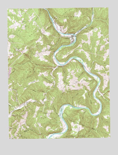
Rowlesburg, WV USGS Topographic Map
Click on map above to begin viewing in our Map Viewer.

This topographic map contains these locations and features:
Feature Name Type Latitude Longitude GNIS ID View Map
Bearwallow RidgeRidgeN39.2879°W79.6503°1550211View Map
Bell HollowValleyN39.3037°W79.6942°1550257View Map
Big RunStreamN39.2807°W79.6703°1550327View Map
Big RunStreamN39.3651°W79.6445°1550336View Map
Birchroot RunStreamN39.2790°W79.7370°1550365View Map
Buckhorn (historical)Populated PlaceN39.3698°W79.7012°1558465View Map
Buckhorn RunStreamN39.3748°W79.7051°1550536View Map
Bucklick RunStreamN39.2745°W79.7484°1550539View Map
Buffalo CreekStreamN39.3209°W79.6867°1550542View Map
Burns CemeteryCemeteryN39.3298°W79.7037°1550563View Map
Burns School (historical)SchoolN39.3329°W79.7090°1558470View Map
Cannon HillSummitN39.3543°W79.6698°1554061View Map
Charles B. Felton Jr. BridgeBridgeN39.3517°W79.6632°2647537View Map
Cheat River Covered BridgeBridgeN39.3193°W79.6564°1558479View Map
Christ United Methodist ChurchChurchN39.3476°W79.6714°1558485View Map
Community ChurchChurchN39.3343°W79.7356°1550777View Map
Deakins CemeteryCemeteryN39.3209°W79.6545°1550890View Map
Dog RunStreamN39.2859°W79.7070°1550935View Map
ErwinPopulated PlaceN39.2965°W79.6384°1551066View Map
Erwin Methodist ChurchChurchN39.2979°W79.6384°1558511View Map
EtamPopulated PlaceN39.2854°W79.7281°1554413View Map
Etam United Methodist ChurchChurchN39.2845°W79.7273°1558541View Map
Fifth DistrictCivilN39.3129°W79.7078°1928268View Map
Fill HollowValleyN39.3482°W79.6839°1551105View Map
Flag RunStreamN39.3173°W79.6906°1551127View Map
Ford RunStreamN39.2676°W79.6831°1551151View Map
Friends GapGapN39.3351°W79.7359°1551184View Map
Glade RunStreamN39.2723°W79.6381°1551241View Map
Green ValleyValleyN39.2865°W79.7173°1551290View Map
Hannahsville School (historical)SchoolN39.2526°W79.7026°1689357View Map
HardestyPopulated PlaceN39.2915°W79.6334°1558537View Map
High RidgeRidgeN39.2951°W79.6701°1551434View Map
Keyser RunStreamN39.3076°W79.6398°1551645View Map
Knotts Family CemeteryCemeteryN39.3259°W79.7284°2586234View Map
Knotts RidgeRidgeN39.3029°W79.7223°1551669View Map
Little Buffalo CreekStreamN39.3201°W79.6823°1551840View Map
Little Buffalo CreekStreamN39.2782°W79.7401°1551841View Map
Little Wolf CreekStreamN39.2934°W79.6381°1551904View Map
MacomberPopulated PlaceN39.3190°W79.6892°1551984View Map
Macomber School (historical)SchoolN39.3076°W79.6951°1558595View Map
Macomber Truss BridgeBridgeN39.3199°W79.6567°2647539View Map
Madison RunStreamN39.3129°W79.6498°1551987View Map
ManheimPopulated PlaceN39.3604°W79.6909°1551990View Map
Mount Sarah United Methodist ChurchChurchN39.2737°W79.7031°1552217View Map
Mountain ViewPopulated PlaceN39.3612°W79.7317°1558618View Map
Mountain View ChurchChurchN39.3615°W79.7315°1552240View Map
Mountain View School (historical)SchoolN39.3584°W79.7287°1552242View Map
Muddy RunStreamN39.2718°W79.6876°1552258View Map
Panther RunStreamN39.2718°W79.6462°1552429View Map
Pheasant RunStreamN39.3207°W79.7137°1552467View Map
Pickering Farm SpringSpringN39.3362°W79.7276°1558627View Map
Pleasant Valley FordCrossingN39.2765°W79.6845°1558638View Map
Pleasant Valley Schoolhouse (historical)SchoolN39.2751°W79.6826°1558640View Map
Redrock ChurchChurchN39.3029°W79.6667°1552625View Map
Redrock Schoolhouse (historical)SchoolN39.3026°W79.6665°1558648View Map
Reno District (historical)CivilN39.3304°W79.7262°1928344View Map
Riverview CemeteryCemeteryN39.3418°W79.6712°1552676View Map
RowlesburgPopulated PlaceN39.3484°W79.6709°1552749View Map
Rowlesburg Police DepartmentBuildingN39.3459°W79.6688°2728140View Map
Rowlesburg Post OfficePost OfficeN39.3469°W79.6681°1558655View Map
Rowlesburg SchoolSchoolN39.3561°W79.6862°1558654View Map
Rowlesburg Town HallBuildingN39.3457°W79.6681°1558656View Map
Rowlesburg Volunteer Ambulance Service 10BuildingN39.3465°W79.6686°2581156View Map
Rowlesburg Volunteer Fire DepartmentBuildingN39.3465°W79.6674°2577555View Map
Rowlesburg W-Beam BridgeBridgeN39.3497°W79.6679°2647534View Map
Saint Pauls Methodist Protestant Church (historical)ChurchN39.3645°W79.6692°1558660View Map
Saint Philomena Catholic ChurchChurchN39.3473°W79.6726°1558661View Map
Salem School (historical)SchoolN39.3151°W79.6453°1558665View Map
Saltlick CreekStreamN39.3498°W79.6667°1552778View Map
Sanders CemeteryCemeteryN39.3518°W79.7073°1552793View Map
Saunders School (historical)SchoolN39.3507°W79.7051°1558668View Map
Scott RunStreamN39.3148°W79.6548°1552820View Map
Seven IslandsIslandN39.2754°W79.6853°1552837View Map
Sinclair RidgeRidgeN39.2826°W79.6981°1552899View Map
Stave RunStreamN39.2779°W79.6526°1553045View Map
Town of RowlesburgCivilN39.3482°W79.6763°2391397View Map
Tray RunStreamN39.3584°W79.6934°1553256View Map
Tray Run ViaductBridgeN39.3579°W79.6942°1558691View Map
Victory ChurchChurchN39.3357°W79.6965°1553346View Map
Watkins CemeteryCemeteryN39.3284°W79.7098°1553391View Map
Wildcat RunStreamN39.2948°W79.7023°1553453View Map
Wolf CreekStreamN39.2976°W79.6412°1553494View Map
Wotring ChapelChurchN39.3545°W79.6434°1553520View Map

Note: Coordinates in the location and feature list above are referenced to NAD83 datum.


Copyright (C) 2008-2025 Ryan Niemi / Sunset Dynamics ... All Rights Reserved