TopoQuest Logo
Do you find TopoQuest useful?
Help keep TopoQuest running and adding new maps/features by donating!
Bitcoin:  19c7KJd3qBynnjoSw5npx9KScwjBe4ifkT
Litecoin:  LXs6TkuXGGXo1vDsWCkWVdjQX94eUKd6ui
Home View Maps Find Maps Find Places Resources & Links


Ruskin, Nebraska Topographic Map

USGS Map Title: Ruskin, NE
USGS Map MRC: 40097B7
DRG (GeoTIFF) Download: o40097b7.tif


Neighboring USGS Topographic Map Quads:


  Edgar, NE  
40097C8
 

  Davenport, NE  
40097C7
 

  Carleton, NE  
40097C6
 

  Oak, NE  
40097B8
 

  Ruskin, NE  
40097B7
 

  Deshler, NE  
40097B6
 

  Hardy, NE  
40097A8
 

  Byron, NE  
40097A7
 

  Hebron SW, NE  
40097A6


Map MRC Location:

N41°
W98°
N41°
W97°
H8 H7 H6 H5 H4 H3 H2 H1
G8 G7 G6 G5 G4 G3 G2 G1
F8 F7 F6 F5 F4 F3 F2 F1
E8 E7 E6 E5 E4 E3 E2 E1
D8 D7 D6 D5 D4 D3 D2 D1
C8 C7 C6 C5 C4 C3 C2 C1
B8 B7 B6 B5 B4 B3 B2 B1
A8 A7 A6 A5 A4 A3 A2 A1
N40°
W98°
N40°
W97°

Ruskin, NE USGS 1:24K Topographic Map Preview:
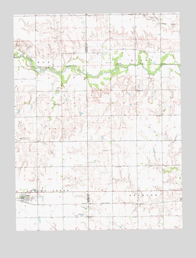
Ruskin, NE USGS Topographic Map
Click on map above to begin viewing in our Map Viewer.

This topographic map contains these locations and features:
Feature Name Type Latitude Longitude GNIS ID View Map
Bethlehem Lutheran Parochial School (historical)SchoolN40.2050°W97.7820°827393View Map
Drohman DamDamN40.1936°W97.8262°1767222View Map
Drohman ReservoirReservoirN40.1930°W97.8262°1767223View Map
Ehlers DamDamN40.1700°W97.7586°1767616View Map
Ehlers ReservoirReservoirN40.1721°W97.7580°1767617View Map
Farmers Union Cooperative Association ElevatorLocaleN40.1439°W97.8692°1882696View Map
Immanuel Lutheran Parochial School (historical)SchoolN40.1481°W97.7587°1882955View Map
Kiowa School (historical)SchoolN40.1911°W97.7545°1882905View Map
Lipker DamDamN40.1952°W97.8720°1767436View Map
Lipker ReservoirLakeN40.1941°W97.8720°1767437View Map
Mount Zion CemeteryCemeteryN40.1978°W97.8392°831489View Map
Oak CemeteryCemeteryN40.2325°W97.8737°831793View Map
RuskinPopulated PlaceN40.1439°W97.8692°832789View Map
Ruskin (historical)LocaleN40.1417°W97.8678°1882697View Map
Ruskin Ball Field and ParkParkN40.1439°W97.8692°1882692View Map
Ruskin Post OfficePost OfficeN40.1441°W97.8699°1882698View Map
Ruskin Public LibraryBuildingN40.1439°W97.8692°1882693View Map
Ruskin Volunteer Fire DepartmentBuildingN40.1443°W97.8691°1882694View Map
Saint Marks CemeteryCemeteryN40.1328°W97.8192°832966View Map
Saint Marks Lutheran ChurchChurchN40.1439°W97.8692°1882695View Map
Saint Marks Lutheran Parochial School (historical)SchoolN40.1333°W97.8198°1882956View Map
Saint Pauls CemeteryCemeteryN40.1614°W97.7987°833064View Map
Saint Peters CemeteryCemeteryN40.1472°W97.7575°833092View Map
Sunshine Valley School (historical)SchoolN40.2278°W97.8198°1882904View Map
Thawes CreekStreamN40.2161°W97.8378°834070View Map
Township of KiowaCivilN40.2083°W97.7670°1883049View Map
Turtle CreekStreamN40.2253°W97.8745°834228View Map
Village of RuskinCivilN40.1440°W97.8670°2399145View Map

Note: Coordinates in the location and feature list above are referenced to NAD83 datum.


Copyright (C) 2008-2024 Ryan Niemi / Sunset Dynamics ... All Rights Reserved