TopoQuest Logo
Do you find TopoQuest useful?
Help keep TopoQuest running and adding new maps/features by donating!
Bitcoin:  19c7KJd3qBynnjoSw5npx9KScwjBe4ifkT
Litecoin:  LXs6TkuXGGXo1vDsWCkWVdjQX94eUKd6ui
Home View Maps Find Maps Find Places Resources & Links


Deshler, Nebraska Topographic Map

USGS Map Title: Deshler, NE
USGS Map MRC: 40097B6
DRG (GeoTIFF) Download: o40097b6.tif


Neighboring USGS Topographic Map Quads:


  Davenport, NE  
40097C7
 

  Carleton, NE  
40097C6
 

  Bruning, NE  
40097C5
 

  Ruskin, NE  
40097B7
 

  Deshler, NE  
40097B6
 

  Hebron, NE  
40097B5
 

  Byron, NE  
40097A7
 

  Hebron SW, NE  
40097A6
 

  Chester, NE  
40097A5


Map MRC Location:

N41°
W98°
N41°
W97°
H8 H7 H6 H5 H4 H3 H2 H1
G8 G7 G6 G5 G4 G3 G2 G1
F8 F7 F6 F5 F4 F3 F2 F1
E8 E7 E6 E5 E4 E3 E2 E1
D8 D7 D6 D5 D4 D3 D2 D1
C8 C7 C6 C5 C4 C3 C2 C1
B8 B7 B6 B5 B4 B3 B2 B1
A8 A7 A6 A5 A4 A3 A2 A1
N40°
W98°
N40°
W97°

Deshler, NE USGS 1:24K Topographic Map Preview:
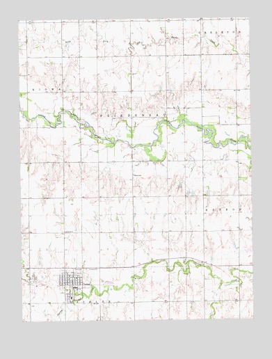
Deshler, NE USGS Topographic Map
Click on map above to begin viewing in our Map Viewer.

This topographic map contains these locations and features:
Feature Name Type Latitude Longitude GNIS ID View Map
Abiding Word Lutheran ChurchChurchN40.1408°W97.7228°1883031View Map
City of DeshlerCivilN40.1396°W97.7234°2394525View Map
DeshlerPopulated PlaceN40.1408°W97.7228°828686View Map
Deshler (historical)LocaleN40.1395°W97.7225°1883020View Map
Deshler City ParkParkN40.1408°W97.7228°1883023View Map
Deshler City Park CampgroundLocaleN40.1408°W97.7228°1883024View Map
Deshler Election PrecinctCivilN40.1399°W97.7410°1928815View Map
Deshler Grain and Feed ElevatorLocaleN40.1408°W97.7228°1883025View Map
Deshler Lutheran Elementary SchoolSchoolN40.1428°W97.7206°1882960View Map
Deshler Medical ClinicHospitalN40.1408°W97.7228°1883028View Map
Deshler Post OfficePost OfficeN40.1425°W97.7233°1883021View Map
Deshler Public LibraryBuildingN40.1422°W97.7234°1883022View Map
Deshler Public SchoolsSchoolN40.1345°W97.7234°1882962View Map
Deshler Volunteer Fire and RescueBuildingN40.1422°W97.7224°2553446View Map
Fairbury ClinicHospitalN40.1408°W97.7228°1883026View Map
Friedensau Historical MarkerParkN40.1472°W97.6906°1883085View Map
Hackney School (historical)SchoolN40.2050°W97.6420°1882907View Map
Kiowa-Friedensau Election Precinct (historical)CivilN40.2072°W97.7375°1928999View Map
North Friedensau School (historical)SchoolN40.2333°W97.7059°1882957View Map
North Star School (historical)SchoolN40.1620°W97.7264°836820View Map
Old Rock School (historical)SchoolN40.1767°W97.7378°1882906View Map
Parkview HavenHospitalN40.1408°W97.7228°1883027View Map
Peace CemeteryCemeteryN40.1464°W97.7217°832014View Map
Peace Lutheran ChurchChurchN40.1408°W97.7228°1883030View Map
Peace Lutheran School (historical)SchoolN40.1425°W97.7245°1882954View Map
Saint Peter Lutheran ChurchChurchN40.1431°W97.7220°1883029View Map
Saint Peters CemeteryCemeteryN40.1464°W97.7145°833091View Map
Township of DeshlerCivilN40.1256°W97.7498°1883051View Map
Township of FriedensauCivilN40.2083°W97.6837°1882943View Map
Trinity Lutheran ChurchChurchN40.1856°W97.6892°1883019View Map
Trinity Lutheran Parochial School (historical)SchoolN40.1850°W97.6887°834178View Map
Wiedel DamDamN40.1535°W97.6260°1767628View Map
Wiedel ReservoirLakeN40.1533°W97.6277°1767629View Map

Note: Coordinates in the location and feature list above are referenced to NAD83 datum.


Copyright (C) 2008-2024 Ryan Niemi / Sunset Dynamics ... All Rights Reserved