TopoQuest Logo
Do you find TopoQuest useful?
Help keep TopoQuest running and adding new maps/features by donating!
Bitcoin:  19c7KJd3qBynnjoSw5npx9KScwjBe4ifkT
Litecoin:  LXs6TkuXGGXo1vDsWCkWVdjQX94eUKd6ui
Home View Maps Find Maps Find Places Resources & Links


Russellville, Kentucky Topographic Map

USGS Map Title: Russellville, KY
USGS Map MRC: 36086G8
DRG (GeoTIFF) Download: o36086g8.tif


Neighboring USGS Topographic Map Quads:


  Sharon Grove, KY  
36087H1
 

  Lewisburg, KY  
36086H8
 

  Homer, KY  
36086H7
 

  Olmstead, KY  
36087G1
 

  Russellville, KY  
36086G8
 

  Dennis, KY  
36086G7
 

  Allensville, KY  
36087F1
 

  Dot, KY  
36086F8
 

  Adairville, KY  
36086F7


Map MRC Location:

N37°
W87°
N37°
W86°
H8 H7 H6 H5 H4 H3 H2 H1
G8 G7 G6 G5 G4 G3 G2 G1
F8 F7 F6 F5 F4 F3 F2 F1
E8 E7 E6 E5 E4 E3 E2 E1
D8 D7 D6 D5 D4 D3 D2 D1
C8 C7 C6 C5 C4 C3 C2 C1
B8 B7 B6 B5 B4 B3 B2 B1
A8 A7 A6 A5 A4 A3 A2 A1
N36°
W87°
N36°
W86°

Russellville, KY USGS 1:24K Topographic Map Preview:
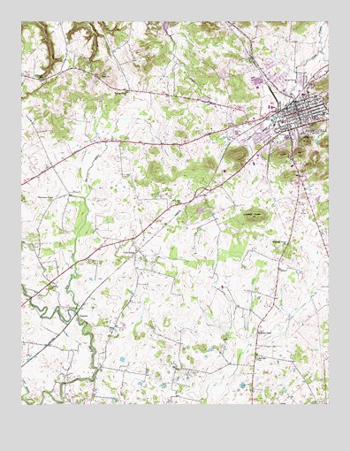
Russellville, KY USGS Topographic Map
Click on map above to begin viewing in our Map Viewer.

This topographic map contains these locations and features:
Feature Name Type Latitude Longitude GNIS ID View Map
Cave SpringsPopulated PlaceN36.7992°W86.9533°507669View Map
City of RussellvilleCivilN36.8393°W86.8950°2404659View Map
County Home CemeteryCemeteryN36.8370°W86.9155°490158View Map
Doyle CemeteryCemeteryN36.8570°W86.9672°491081View Map
Dry ForkStreamN36.7806°W86.9789°491181View Map
FergusonPopulated PlaceN36.7795°W86.9772°507990View Map
Lebanon ChurchChurchN36.7878°W86.9883°496133View Map
Logan CountyCivilN36.8597°W86.8789°516917View Map
Logan County Sheriff's OfficeBuildingN36.8452°W86.8901°2767430View Map
Logan Memorial HospitalHospitalN36.8160°W86.8814°2660343View Map
Luckett KnobSummitN36.8117°W86.9056°497332View Map
Maple Grove CemeteryCemeteryN36.8379°W86.8931°2680853View Map
O'Roark ChurchChurchN36.8562°W86.9914°499648View Map
Post Oak (historical)Populated PlaceN36.8155°W86.9356°2743094View Map
Post Oak ChurchChurchN36.8156°W86.9344°501171View Map
Red Oak ChurchChurchN36.7653°W86.9044°501670View Map
Rock Crusher Pond (historical)LakeN36.8623°W86.9066°2743095View Map
RussellvillePopulated PlaceN36.8453°W86.8872°502534View Map
Russellville DivisionCivilN36.8423°W86.9250°1937230View Map
Russellville Fire DepartmentBuildingN36.8446°W86.8875°2636567View Map
Russellville Police DepartmentBuildingN36.8448°W86.8878°2767634View Map
Russellville Rural Fire DepartmentBuildingN36.8510°W86.9191°2636992View Map
Stevenson ChapelChurchN36.8167°W86.9881°515697View Map
Vicks BranchStreamN36.7506°W86.9964°506041View Map
Walnut Grove (historical)Populated PlaceN36.8521°W86.9559°2743106View Map
Walnut Grove ChurchChurchN36.8520°W86.9572°506170View Map
WBVR-FM (Russellville)TowerN36.8445°W86.9197°517735View Map
Whitaker Grove ChurchChurchN36.8023°W86.8919°506568View Map
Williams StoreLocaleN36.7739°W86.9039°506829View Map
WRUS-AM (Russellville)TowerN36.8142°W86.8806°517658View Map
WRUS-AM (Russellville)TowerN36.8748°W86.8822°517660View Map

Note: Coordinates in the location and feature list above are referenced to NAD83 datum.


Copyright (C) 2008-2024 Ryan Niemi / Sunset Dynamics ... All Rights Reserved