TopoQuest Logo
Do you find TopoQuest useful?
Help keep TopoQuest running and adding new maps/features by donating!
Bitcoin:  19c7KJd3qBynnjoSw5npx9KScwjBe4ifkT
Litecoin:  LXs6TkuXGGXo1vDsWCkWVdjQX94eUKd6ui
Home View Maps Find Maps Find Places Resources & Links


Homer, Kentucky Topographic Map

USGS Map Title: Homer, KY
USGS Map MRC: 36086H7
DRG (GeoTIFF) Download: o36086h7.tif


Neighboring USGS Topographic Map Quads:


  Dunmor, KY  
37086A8
 

  Quality, KY  
37086A7
 

  Sugar Grove, KY  
37086A6
 

  Lewisburg, KY  
36086H8
 

  Homer, KY  
36086H7
 

  South Union, KY  
36086H6
 

  Russellville, KY  
36086G8
 

  Dennis, KY  
36086G7
 

  Auburn, KY  
36086G6


Map MRC Location:

N37°
W87°
N37°
W86°
H8 H7 H6 H5 H4 H3 H2 H1
G8 G7 G6 G5 G4 G3 G2 G1
F8 F7 F6 F5 F4 F3 F2 F1
E8 E7 E6 E5 E4 E3 E2 E1
D8 D7 D6 D5 D4 D3 D2 D1
C8 C7 C6 C5 C4 C3 C2 C1
B8 B7 B6 B5 B4 B3 B2 B1
A8 A7 A6 A5 A4 A3 A2 A1
N36°
W87°
N36°
W86°

Homer, KY USGS 1:24K Topographic Map Preview:
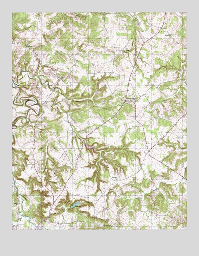
Homer, KY USGS Topographic Map
Click on map above to begin viewing in our Map Viewer.

This topographic map contains these locations and features:
Feature Name Type Latitude Longitude GNIS ID View Map
Auburn Volunteer Fire Department SubstationBuildingN36.9489°W86.7938°2636772View Map
Bethel ChurchChurchN36.9481°W86.8511°486962View Map
Big Muddy ChurchChurchN36.9778°W86.7942°487225View Map
Briggs LakeReservoirN36.8893°W86.8298°487909View Map
Cedar Grove (historical)Populated PlaceN36.9100°W86.8550°2743069View Map
Cedar Grove CemeteryCemeteryN36.9095°W86.8542°489194View Map
Chandlers ChapelPopulated PlaceN36.9492°W86.7931°489328View Map
Concord (historical)Populated PlaceN36.8852°W86.8708°2743070View Map
Concord ChurchChurchN36.8814°W86.8719°489924View Map
Concord SchoolSchoolN36.8895°W86.8714°489943View Map
CostelowPopulated PlaceN36.9909°W86.7678°507764View Map
Duncan ChapelChurchN36.8767°W86.8039°491299View Map
Happy HollowPopulated PlaceN36.9191°W86.8083°2743078View Map
HomerPopulated PlaceN36.9614°W86.8397°494465View Map
InscoPopulated PlaceN36.9812°W86.8644°494995View Map
Lone Pine AerodromeAirportN36.9113°W86.7862°517334View Map
Motts Lick CreekStreamN36.9598°W86.8742°498686View Map
Oak Grove (historical)Populated PlaceN36.9174°W86.8270°2743087View Map
Oak Grove ChurchChurchN36.9162°W86.8264°499672View Map
Patterson CreekStreamN36.9525°W86.8392°500258View Map
Plainview ChurchChurchN36.9037°W86.8000°500791View Map
RogersPopulated PlaceN36.8772°W86.7919°2743096View Map
Sycamore ChurchChurchN36.9875°W86.7608°504872View Map
Town BranchStreamN36.8828°W86.8683°505385View Map

Note: Coordinates in the location and feature list above are referenced to NAD83 datum.


Copyright (C) 2008-2025 Ryan Niemi / Sunset Dynamics ... All Rights Reserved