TopoQuest Logo
Do you find TopoQuest useful?
Help keep TopoQuest running and adding new maps/features by donating!
Bitcoin:  19c7KJd3qBynnjoSw5npx9KScwjBe4ifkT
Litecoin:  LXs6TkuXGGXo1vDsWCkWVdjQX94eUKd6ui
Home View Maps Find Maps Find Places Resources & Links


S'Ocholis Canyon, Oregon Topographic Map

USGS Map Title: S'Ocholis Canyon, OR
USGS Map MRC: 42121E6
DRG (GeoTIFF) Download: o42121e6.tif


Neighboring USGS Topographic Map Quads:


  Soloman Butte, OR  
42121F7
 

  Applegate Butte, OR  
42121F6
 

  Calimus Butte, OR  
42121F5
 

  Chiloquin, OR  
42121E7
 

  S'Ocholis Canyon, OR  
42121E6
 

  Buttes of the Gods, OR  
42121E5
 

  Modoc Point, OR  
42121D7
 

  Swan Lake Point, OR  
42121D6
 

  Sprague River West, OR  
42121D5


Map MRC Location:

N43°
W122°
N43°
W121°
H8 H7 H6 H5 H4 H3 H2 H1
G8 G7 G6 G5 G4 G3 G2 G1
F8 F7 F6 F5 F4 F3 F2 F1
E8 E7 E6 E5 E4 E3 E2 E1
D8 D7 D6 D5 D4 D3 D2 D1
C8 C7 C6 C5 C4 C3 C2 C1
B8 B7 B6 B5 B4 B3 B2 B1
A8 A7 A6 A5 A4 A3 A2 A1
N42°
W122°
N42°
W121°

S'Ocholis Canyon, OR USGS 1:24K Topographic Map Preview:
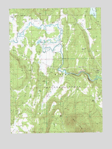
S'Ocholis Canyon, OR USGS Topographic Map
Click on map above to begin viewing in our Map Viewer.

This topographic map contains these locations and features:
Feature Name Type Latitude Longitude GNIS ID View Map
Borrow ReservoirReservoirN42.5518°W121.7028°1155430View Map
Cedar SpringSpringN42.5167°W121.6813°1139527View Map
Chiloquin Agency Lake Fire District Station 3BuildingN42.5807°W121.7357°2577046View Map
Corbell DitchCanalN42.5762°W121.6928°1154826View Map
Dockney FlatFlatN42.5429°W121.6925°1141098View Map
Flat LakeLakeN42.5274°W121.6927°1162434View Map
Four Point SpringSpringN42.6106°W121.6313°1638128View Map
Harris ReservoirReservoirN42.5852°W121.6410°1157117View Map
Hawks LakeLakeN42.6227°W121.6363°1155428View Map
Kamkaun SpringSpringN42.5908°W121.7057°1144482View Map
Lone Pine QuarryMineN42.5590°W121.6325°1135936View Map
Lone Pine ReservoirReservoirN42.5609°W121.6293°1155429View Map
Long PrairieFlatN42.6018°W121.6478°1145429View Map
Long Prairie ReservoirReservoirN42.6040°W121.6445°1133257View Map
Mahogany Ridge ReservoirReservoirN42.5833°W121.6531°1162432View Map
McCready RanchLocaleN42.5907°W121.6836°1145951View Map
McReady SpringSpringN42.5870°W121.6794°1157116View Map
No Name FlatFlatN42.5421°W121.7214°1146856View Map
Nut ReservoirReservoirN42.5426°W121.7125°1155431View Map
Quarry ReservoirReservoirN42.5324°W121.6368°1162435View Map
S'Ocholis Campground (historical)LocaleN42.5596°W121.6483°1162433View Map
S'Ocholis CanyonValleyN42.5590°W121.6745°1148889View Map
Saddle MountainSummitN42.5107°W121.6653°1148910View Map
Saddle Mountain SpringSpringN42.5221°W121.6261°1162436View Map
Whitehorse SpringSpringN42.6155°W121.7447°1152261View Map
Wolff RanchLocaleN42.5804°W121.6911°1152610View Map
Wrights MeadowsFlatN42.5035°W121.7464°1152664View Map

Note: Coordinates in the location and feature list above are referenced to NAD83 datum.


Copyright (C) 2008-2025 Ryan Niemi / Sunset Dynamics ... All Rights Reserved