TopoQuest Logo
Do you find TopoQuest useful?
Help keep TopoQuest running and adding new maps/features by donating!
Bitcoin:  19c7KJd3qBynnjoSw5npx9KScwjBe4ifkT
Litecoin:  LXs6TkuXGGXo1vDsWCkWVdjQX94eUKd6ui
Home View Maps Find Maps Find Places Resources & Links


Buttes of the Gods, Oregon Topographic Map

USGS Map Title: Buttes of the Gods, OR
USGS Map MRC: 42121E5
DRG (GeoTIFF) Download: o42121e5.tif


Neighboring USGS Topographic Map Quads:


  Applegate Butte, OR  
42121F6
 

  Calimus Butte, OR  
42121F5
 

  Fuego Mountain, OR  
42121F4
 

  S'Ocholis Canyon, OR  
42121E6
 

  Buttes of the Gods, OR  
42121E5
 

  Cooks Mountain, OR  
42121E4
 

  Swan Lake Point, OR  
42121D6
 

  Sprague River West, OR  
42121D5
 

  Sprague River East, OR  
42121D4


Map MRC Location:

N43°
W122°
N43°
W121°
H8 H7 H6 H5 H4 H3 H2 H1
G8 G7 G6 G5 G4 G3 G2 G1
F8 F7 F6 F5 F4 F3 F2 F1
E8 E7 E6 E5 E4 E3 E2 E1
D8 D7 D6 D5 D4 D3 D2 D1
C8 C7 C6 C5 C4 C3 C2 C1
B8 B7 B6 B5 B4 B3 B2 B1
A8 A7 A6 A5 A4 A3 A2 A1
N42°
W122°
N42°
W121°

Buttes of the Gods, OR USGS 1:24K Topographic Map Preview:
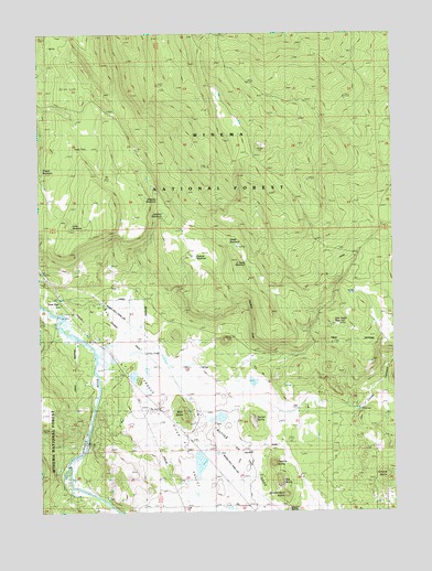
Buttes of the Gods, OR USGS Topographic Map
Click on map above to begin viewing in our Map Viewer.

This topographic map contains these locations and features:
Feature Name Type Latitude Longitude GNIS ID View Map
Antone ButteSummitN42.5096°W121.5028°1137266View Map
Buttes of the GodsSummitN42.5179°W121.5525°1139072View Map
Cooks CanyonValleyN42.5271°W121.5206°1140057View Map
Coyote ButteSummitN42.5124°W121.5442°1140308View Map
Grade ReservoirReservoirN42.5701°W121.5588°1155435View Map
John Smith ReservoirReservoirN42.5489°W121.5221°1155437View Map
Junction ReservoirReservoirN42.5780°W121.5822°1162437View Map
Lone PineLocaleN42.5554°W121.6197°1145352View Map
Long ReservoirReservoirN42.5742°W121.6144°1155434View Map
Magpie ButteSummitN42.5001°W121.5386°1145735View Map
Mousehawk ButteSummitN42.5046°W121.5392°1146553View Map
Pothole ReservoirReservoirN42.5663°W121.5707°1162438View Map
Prairie ReservoirReservoirN42.5891°W121.6246°1155432View Map
Rat ButteSummitN42.5074°W121.5422°1148230View Map
Skunk ButteSummitN42.5240°W121.5511°1149637View Map
South Grade ReservoirReservoirN42.5654°W121.5530°1155436View Map
Sprague River ValleyValleyN42.5488°W121.6206°1150147View Map
Wigwam ReservoirReservoirN42.5819°W121.5840°1155433View Map
Wolf ButteSummitN42.5260°W121.5750°1152572View Map

Note: Coordinates in the location and feature list above are referenced to NAD83 datum.


Copyright (C) 2008-2025 Ryan Niemi / Sunset Dynamics ... All Rights Reserved