TopoQuest Logo
Do you find TopoQuest useful?
Help keep TopoQuest running and adding new maps/features by donating!
Bitcoin:  19c7KJd3qBynnjoSw5npx9KScwjBe4ifkT
Litecoin:  LXs6TkuXGGXo1vDsWCkWVdjQX94eUKd6ui
Home View Maps Find Maps Find Places Resources & Links


Cameron, South Carolina Topographic Map

USGS Map Title: Cameron, SC
USGS Map MRC: 33080E6
DRG (GeoTIFF) Download: o33080e6.tif


Neighboring USGS Topographic Map Quads:


  Saint Matthews, SC  
33080F7
 

  Fort Motte, SC  
33080F6
 

  Lone Star, SC  
33080F5
 

  Orangeburg North, SC  
33080E7
 

  Cameron, SC  
33080E6
 

  Elloree, SC  
33080E5
 

  Orangeburg South, SC  
33080D7
 

  Indian Camp Branch, SC  
33080D6
 

  Felderville, SC  
33080D5


Map MRC Location:

N34°
W81°
N34°
W80°
H8 H7 H6 H5 H4 H3 H2 H1
G8 G7 G6 G5 G4 G3 G2 G1
F8 F7 F6 F5 F4 F3 F2 F1
E8 E7 E6 E5 E4 E3 E2 E1
D8 D7 D6 D5 D4 D3 D2 D1
C8 C7 C6 C5 C4 C3 C2 C1
B8 B7 B6 B5 B4 B3 B2 B1
A8 A7 A6 A5 A4 A3 A2 A1
N33°
W81°
N33°
W80°

Cameron, SC USGS 1:24K Topographic Map Preview:
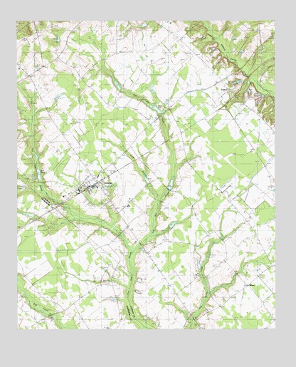
Cameron, SC USGS Topographic Map
Click on map above to begin viewing in our Map Viewer.

This topographic map contains these locations and features:
Feature Name Type Latitude Longitude GNIS ID View Map
Bay BranchStreamN33.5460°W80.7218°1220366View Map
Brown School (historical)SchoolN33.5257°W80.6529°1247008View Map
Browns ChapelChurchN33.5254°W80.6537°1234688View Map
Bull PondReservoirN33.5627°W80.7393°1221106View Map
Bull SwampStreamN33.5013°W80.6881°1247057View Map
CameronPopulated PlaceN33.5577°W80.7145°1247115View Map
Cameron DivisionCivilN33.5656°W80.6499°1938217View Map
Cameron Fire DepartmentBuildingN33.5530°W80.7248°2578703View Map
Cameron Post OfficePost OfficeN33.5577°W80.7155°1252160View Map
Cameron Town Fire DepartmentBuildingN33.5572°W80.7149°2578219View Map
Cook BranchStreamN33.5515°W80.6809°1221722View Map
CrestonPopulated PlaceN33.5974°W80.6476°1231204View Map
Edwards PondReservoirN33.6052°W80.6415°1239590View Map
Edwards Pond Dam D-2688DamN33.6001°W80.6438°1239589View Map
Flea Bite CreekStreamN33.5307°W80.6934°1247775View Map
Four Holes Fire DepartmentBuildingN33.5029°W80.7409°2578494View Map
Gardner SchoolSchoolN33.5077°W80.7295°1222648View Map
Gin BranchStreamN33.5154°W80.6954°1222707View Map
Gum Branch School (historical)SchoolN33.5182°W80.7106°1242647View Map
Harmond PondReservoirN33.5424°W80.6746°1239600View Map
Harmond Pond Dam D-2664DamN33.5418°W80.6748°1239599View Map
Houch PondReservoirN33.5263°W80.6619°1238443View Map
Jericho ChurchChurchN33.5332°W80.6623°1223554View Map
Jessie Rast PondReservoirN33.5605°W80.6868°1239609View Map
Jessie Rast Pond Dam D-2687DamN33.5568°W80.6848°1239608View Map
Mc Neil AirportAirportN33.5579°W80.6503°1251861View Map
MidwayPopulated PlaceN33.5146°W80.6348°1231542View Map
Midway Fire DepartmentBuildingN33.5189°W80.6360°2578525View Map
Midway School (historical)SchoolN33.5190°W80.6362°1234705View Map
Moss LakeReservoirN33.5893°W80.6822°1224669View Map
Mount Cromer Church (historical)ChurchN33.5593°W80.7454°1248722View Map
Mount Cromer School (historical)SchoolN33.5590°W80.7454°1248723View Map
Mount Olive ChurchChurchN33.5988°W80.6451°1224746View Map
Pricketts Pond Dam D-3724DamN33.5468°W80.7431°1240327View Map
Providence ChurchChurchN33.6154°W80.7437°1234714View Map
Providence SchoolSchoolN33.6149°W80.7437°1225703View Map
Saint John ChurchChurchN33.5529°W80.6954°1234717View Map
Saint John Elementary SchoolSchoolN33.5502°W80.6959°1234718View Map
Saint John SchoolSchoolN33.5521°W80.6954°1226133View Map
Saint Matthews ChurchChurchN33.6177°W80.6720°1226215View Map
Saint Paul ChurchChurchN33.6127°W80.6631°1250645View Map
Saint Peter School (historical)SchoolN33.5682°W80.7190°1250684View Map
Saint Peters ChurchChurchN33.5688°W80.7193°1234720View Map
Shady Grove ChurchChurchN33.5893°W80.6762°1226515View Map
Shiloh ChurchChurchN33.6079°W80.7331°1226571View Map
Shuller PondReservoirN33.5124°W80.7032°1238129View Map
South Carolina Noname 09025 D-2640 DamDamN33.5985°W80.6998°1238410View Map
South Carolina Noname 09026 D-2641 DamDamN33.5885°W80.6798°1238412View Map
South Carolina Noname 09027 D-2920 DamDamN33.5585°W80.6748°1238414View Map
South Carolina Noname 09040 D-2921 DamDamN33.5593°W80.7381°1238438View Map
South Carolina Noname 09043 D-2663 DamDamN33.5252°W80.6581°1238442View Map
South Carolina Noname 38021 D-3742 DamDamN33.5118°W80.7031°1238128View Map
T C Moss PondReservoirN33.5989°W80.7010°1238411View Map
Town of CameronCivilN33.5580°W80.7150°2405368View Map
Whetstone PondReservoirN33.6152°W80.7315°1239653View Map
Whetstone Pond Dam D-2686DamN33.6152°W80.7315°1239652View Map

Note: Coordinates in the location and feature list above are referenced to NAD83 datum.


Copyright (C) 2008-2025 Ryan Niemi / Sunset Dynamics ... All Rights Reserved