TopoQuest Logo
Do you find TopoQuest useful?
Help keep TopoQuest running and adding new maps/features by donating!
Bitcoin:  19c7KJd3qBynnjoSw5npx9KScwjBe4ifkT
Litecoin:  LXs6TkuXGGXo1vDsWCkWVdjQX94eUKd6ui
Home View Maps Find Maps Find Places Resources & Links


Saint Peter, Wisconsin Topographic Map

USGS Map Title: Saint Peter, WI
USGS Map MRC: 43088G3
DRG (GeoTIFF) Download: o43088g3.tif


Neighboring USGS Topographic Map Quads:


  Fahrney Point, WI  
43088H4
 

  Brothertown, WI  
43088H3
 

  Marytown, WI  
43088H2
 

  Fond du Lac, WI  
43088G4
 

  Saint Peter, WI  
43088G3
 

  Saint Cloud, WI  
43088G2
 

  Byron, WI  
43088F4
 

  Eden, WI  
43088F3
 

  Dundee, WI  
43088F2


Map MRC Location:

N44°
W89°
N44°
W88°
H8 H7 H6 H5 H4 H3 H2 H1
G8 G7 G6 G5 G4 G3 G2 G1
F8 F7 F6 F5 F4 F3 F2 F1
E8 E7 E6 E5 E4 E3 E2 E1
D8 D7 D6 D5 D4 D3 D2 D1
C8 C7 C6 C5 C4 C3 C2 C1
B8 B7 B6 B5 B4 B3 B2 B1
A8 A7 A6 A5 A4 A3 A2 A1
N43°
W89°
N43°
W88°

Saint Peter, WI USGS 1:24K Topographic Map Preview:
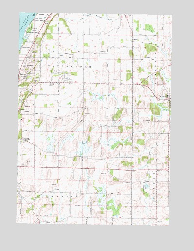
Saint Peter, WI USGS Topographic Map
Click on map above to begin viewing in our Map Viewer.

This topographic map contains these locations and features:
Feature Name Type Latitude Longitude GNIS ID View Map
Bergen BeachPopulated PlaceN43.8605°W88.3709°1561587View Map
Blaine School (historical)SchoolN43.7686°W88.3309°1845734View Map
Cherry Hill OrchardLocaleN43.7764°W88.2900°2726614View Map
Consolidated Parochial Elementary SchoolSchoolN43.8266°W88.2531°2716560View Map
DotyvillePopulated PlaceN43.7522°W88.2609°1564077View Map
Edison School (historical)SchoolN43.7511°W88.3507°1845767View Map
Forest CemeteryCemeteryN43.7770°W88.2758°1565108View Map
Freund Dairy FarmLocaleN43.8653°W88.3419°2726896View Map
Gladstone BeachPopulated PlaceN43.8655°W88.3690°1565551View Map
Holy Cross CemeteryCemeteryN43.8242°W88.2504°1845818View Map
Linden BeachPopulated PlaceN43.8542°W88.3734°1568133View Map
MalonePopulated PlaceN43.8603°W88.2815°1568921View Map
Mary HillSummitN43.7867°W88.3662°1569102View Map
Nett Construction AirportAirportN43.8313°W88.3266°1581977View Map
Saint Charles CemeteryCemeteryN43.8010°W88.3709°1845906View Map
Saint Charles ChapelChurchN43.8000°W88.3704°1572894View Map
Saint Pauls Lutheran SchoolSchoolN43.7828°W88.2605°1573500View Map
Saint PeterPopulated PlaceN43.8364°W88.3415°1573503View Map
Saint Peter Census Designated PlaceCensusN43.8378°W88.3466°2585074View Map
SilicaPopulated PlaceN43.8503°W88.3418°1574094View Map
Taft SchoolSchoolN43.7858°W88.3404°1575222View Map
Tay-Cal-Mar SchoolSchoolN43.8489°W88.3676°1575264View Map
Taycheedah CemeteryCemeteryN43.7999°W88.3747°1575266View Map
Town of EmpireCivilN43.7530°W88.3392°1583167View Map
Town of TaycheedahCivilN43.8350°W88.3410°1584267View Map
Welling BeachPopulated PlaceN43.8705°W88.3640°1576414View Map
WFON-FM (Fond du Lac)TowerN43.8394°W88.3684°1582385View Map

Note: Coordinates in the location and feature list above are referenced to NAD83 datum.


Copyright (C) 2008-2025 Ryan Niemi / Sunset Dynamics ... All Rights Reserved