TopoQuest Logo
Do you find TopoQuest useful?
Help keep TopoQuest running and adding new maps/features by donating!
Bitcoin:  19c7KJd3qBynnjoSw5npx9KScwjBe4ifkT
Litecoin:  LXs6TkuXGGXo1vDsWCkWVdjQX94eUKd6ui
Home View Maps Find Maps Find Places Resources & Links


Dundee, Wisconsin Topographic Map

USGS Map Title: Dundee, WI
USGS Map MRC: 43088F2
DRG (GeoTIFF) Download: o43088f2.tif


Neighboring USGS Topographic Map Quads:


  Saint Peter, WI  
43088G3
 

  Saint Cloud, WI  
43088G2
 

  Elkhart Lake, WI  
43088G1
 

  Eden, WI  
43088F3
 

  Dundee, WI  
43088F2
 

  Cascade, WI  
43088F1
 

  Campbellsport, WI  
43088E3
 

  Kewaskum, WI  
43088E2
 

  Batavia, WI  
43088E1


Map MRC Location:

N44°
W89°
N44°
W88°
H8 H7 H6 H5 H4 H3 H2 H1
G8 G7 G6 G5 G4 G3 G2 G1
F8 F7 F6 F5 F4 F3 F2 F1
E8 E7 E6 E5 E4 E3 E2 E1
D8 D7 D6 D5 D4 D3 D2 D1
C8 C7 C6 C5 C4 C3 C2 C1
B8 B7 B6 B5 B4 B3 B2 B1
A8 A7 A6 A5 A4 A3 A2 A1
N43°
W89°
N43°
W88°

Dundee, WI USGS 1:24K Topographic Map Preview:
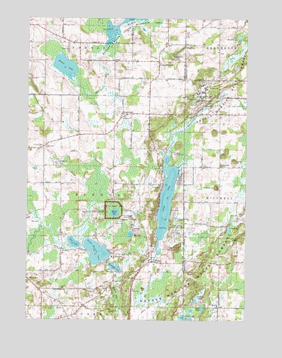
Dundee, WI USGS Topographic Map
Click on map above to begin viewing in our Map Viewer.

This topographic map contains these locations and features:
Feature Name Type Latitude Longitude GNIS ID View Map
ArmstrongPopulated PlaceN43.7103°W88.1948°1577494View Map
Armstrong CemeteryCemeteryN43.7104°W88.1965°1845722View Map
Armstrong School (historical)SchoolN43.7033°W88.1812°1845723View Map
Bear LakeLakeN43.7360°W88.1308°1561391View Map
Birchwood LakeLakeN43.6468°W88.1999°1561819View Map
Butler LakeLakeN43.6627°W88.1344°1562469View Map
Butler Lake and Flynn's Spring State Natural AreaParkN43.6619°W88.1329°2055596View Map
Camp Long LakeLocaleN43.6939°W88.1657°1562630View Map
Camp VistaLocaleN43.6631°W88.1901°1562668View Map
Cedar LakeLakeN43.6300°W88.1497°1562849View Map
Cedar LakeLakeN43.6605°W88.1909°1562850View Map
ChinatownPopulated PlaceN43.6846°W88.1633°2741629View Map
Conner HillSummitN43.6914°W88.1323°1563322View Map
Crooked Lake Wetlands State Natural AreaParkN43.6272°W88.1623°2055598View Map
DundeePopulated PlaceN43.6553°W88.1645°1564179View Map
Dundee DamDamN43.6517°W88.1751°1791916View Map
Dundee MountainSummitN43.6553°W88.1643°1564180View Map
Flynns SpringSpringN43.6592°W88.1329°1565094View Map
Garriety HillSummitN43.6894°W88.1395°1565427View Map
Graham CornersPopulated PlaceN43.7325°W88.1751°1565705View Map
Kellings LakesLakeN43.6348°W88.1528°1567383View Map
Kettle Moraine AirportAirportN43.6682°W88.1953°1581950View Map
Kettle Moraine Correctional InstitutionBuildingN43.7197°W88.1498°1581246View Map
Kettle Moraine Correctional Institution SchoolSchoolN43.7194°W88.1501°2716464View Map
Kettle Moraine LakeLakeN43.6533°W88.2103°1567440View Map
Kutz FarmLocaleN43.6531°W88.2219°2726922View Map
Little Round LakeLakeN43.7425°W88.1295°1568391View Map
Long LakeReservoirN43.6750°W88.1706°1568573View Map
Long Lake Recreation AreaParkN43.6631°W88.1648°1568591View Map
McMullen HillSummitN43.6800°W88.1415°1569269View Map
Meadow Creek FarmLocaleN43.6992°W88.2128°2726964View Map
Milwaukee River Tamarack Lowlands and Dundee Kame State Natural AreaParkN43.6378°W88.1759°2059227View Map
Mitchell CemeteryCemeteryN43.6970°W88.2416°1569614View Map
Mitchell School (historical)SchoolN43.6994°W88.2307°1845863View Map
Mud LakeLakeN43.6569°W88.2232°1569914View Map
Mullet LakeLakeN43.7300°W88.2290°1570024View Map
Mullet River State Wildlife AreaParkN43.7433°W88.1965°1570027View Map
Parnell EskerRidgeN43.6664°W88.1309°1571064View Map
Pius School (historical)SchoolN43.6808°W88.1398°1834645View Map
Rainbow AcresLocaleN43.7108°W88.2194°2726926View Map
Sacred Heart CemeteryCemeteryN43.6480°W88.1808°1845761View Map
Shepherd of the Hills SchoolSchoolN43.6982°W88.2331°2716879View Map
Spruce LakeLakeN43.6694°W88.2000°1574734View Map
Spruce Lake Bog National LandmarkLocaleN43.6697°W88.1995°1574739View Map
Spruce Lake Bog State Natural AreaParkN43.6700°W88.2009°2059236View Map
State Road School (historical)SchoolN43.7492°W88.1457°1834721View Map
Tittle LakeLakeN43.6917°W88.1704°2761283View Map
Town of OsceolaCivilN43.6741°W88.2204°1583873View Map
Trinity CemeteryCemeteryN43.6491°W88.1439°1575609View Map
Union CemeteryCemeteryN43.7252°W88.1707°1575882View Map
Watercress CreekStreamN43.6869°W88.1670°1576286View Map

Note: Coordinates in the location and feature list above are referenced to NAD83 datum.


Copyright (C) 2008-2025 Ryan Niemi / Sunset Dynamics ... All Rights Reserved