TopoQuest Logo
Do you find TopoQuest useful?
Help keep TopoQuest running and adding new maps/features by donating!
Bitcoin:  19c7KJd3qBynnjoSw5npx9KScwjBe4ifkT
Litecoin:  LXs6TkuXGGXo1vDsWCkWVdjQX94eUKd6ui
Home View Maps Find Maps Find Places Resources & Links


Saline City, Missouri Topographic Map

USGS Map Title: Saline City, MO
USGS Map MRC: 39092B8
DRG (GeoTIFF) Download: o39092b8.tif


Neighboring USGS Topographic Map Quads:


  New Frankfort, MO  
39093C1
 

  Cambridge, MO  
39092C8
 

  Forest Green, MO  
39092C7
 

  Slater, MO  
39093B1
 

  Saline City, MO  
39092B8
 

  Glasgow, MO  
39092B7
 

  Napton, MO  
39093A1
 

  Arrow Rock, MO  
39092A8
 

  Franklin, MO  
39092A7


Map MRC Location:

N40°
W93°
N40°
W92°
H8 H7 H6 H5 H4 H3 H2 H1
G8 G7 G6 G5 G4 G3 G2 G1
F8 F7 F6 F5 F4 F3 F2 F1
E8 E7 E6 E5 E4 E3 E2 E1
D8 D7 D6 D5 D4 D3 D2 D1
C8 C7 C6 C5 C4 C3 C2 C1
B8 B7 B6 B5 B4 B3 B2 B1
A8 A7 A6 A5 A4 A3 A2 A1
N39°
W93°
N39°
W92°

Saline City, MO USGS 1:24K Topographic Map Preview:
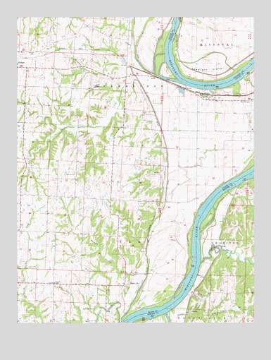
Saline City, MO USGS Topographic Map
Click on map above to begin viewing in our Map Viewer.

This topographic map contains these locations and features:
Feature Name Type Latitude Longitude GNIS ID View Map
All Saints CemeteryCemeteryN39.1859°W92.9249°713207View Map
Annaheim School (historical)SchoolN39.2097°W92.9057°743553View Map
BluffportLocaleN39.1842°W92.8757°743523View Map
Buzzard BranchStreamN39.1447°W92.9316°715143View Map
Cambridge BendBendN39.2258°W92.8806°2109560View Map
Chocolate CreekStreamN39.2242°W92.9380°715801View Map
Elm Grove School (historical)SchoolN39.2125°W92.8771°743568View Map
Epperson IslandIslandN39.2275°W92.8996°717618View Map
Euphrase BendBendN39.1414°W92.9103°2109654View Map
Fish CreekStreamN39.1259°W92.9444°717937View Map
Fish Creek BendBendN39.1689°W92.9039°738635View Map
Fish Creek ChurchChurchN39.1859°W92.9705°717938View Map
Gilliam CemeteryCemeteryN39.2353°W92.9907°718454View Map
Linridge School (historical)SchoolN39.1507°W92.8949°743482View Map
Pleasant Hill School (historical)SchoolN39.1797°W92.9791°743589View Map
Pleasant Valley School (historical)SchoolN39.1867°W92.9494°743591View Map
Richland CreekStreamN39.1492°W92.9035°725276View Map
Riverview School (historical)SchoolN39.1617°W92.9752°743596View Map
Saint Paul ChurchChurchN39.1413°W92.9804°725870View Map
Saint Pauls School (historical)SchoolN39.1415°W92.9805°2573559View Map
Saline CityPopulated PlaceN39.1403°W92.9432°740019View Map
Saline Valley School (historical)SchoolN39.1881°W92.9041°743599View Map
Sappington CemeteryCemeteryN39.1309°W92.9591°726058View Map
Slater PondLakeN39.2219°W92.9592°726534View Map
Turtle LakeLakeN39.2179°W92.9012°727915View Map
West GlasgowPopulated PlaceN39.2161°W92.8766°741348View Map

Note: Coordinates in the location and feature list above are referenced to NAD83 datum.


Copyright (C) 2008-2024 Ryan Niemi / Sunset Dynamics ... All Rights Reserved