TopoQuest Logo
Do you find TopoQuest useful?
Help keep TopoQuest running and adding new maps/features by donating!
Bitcoin:  19c7KJd3qBynnjoSw5npx9KScwjBe4ifkT
Litecoin:  LXs6TkuXGGXo1vDsWCkWVdjQX94eUKd6ui
Home View Maps Find Maps Find Places Resources & Links


Napton, Missouri Topographic Map

USGS Map Title: Napton, MO
USGS Map MRC: 39093A1
DRG (GeoTIFF) Download: o39093a1.tif


Neighboring USGS Topographic Map Quads:


  Marshall North, MO  
39093B2
 

  Slater, MO  
39093B1
 

  Saline City, MO  
39092B8
 

  Marshall South, MO  
39093A2
 

  Napton, MO  
39093A1
 

  Arrow Rock, MO  
39092A8
 

  Longwood, MO  
38093H2
 

  Nelson, MO  
38093H1
 

  Pilot Grove North, MO  
38092H8


Map MRC Location:

N40°
W94°
N40°
W93°
H8 H7 H6 H5 H4 H3 H2 H1
G8 G7 G6 G5 G4 G3 G2 G1
F8 F7 F6 F5 F4 F3 F2 F1
E8 E7 E6 E5 E4 E3 E2 E1
D8 D7 D6 D5 D4 D3 D2 D1
C8 C7 C6 C5 C4 C3 C2 C1
B8 B7 B6 B5 B4 B3 B2 B1
A8 A7 A6 A5 A4 A3 A2 A1
N39°
W94°
N39°
W93°

Napton, MO USGS 1:24K Topographic Map Preview:
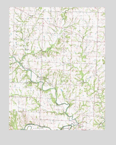
Napton, MO USGS Topographic Map
Click on map above to begin viewing in our Map Viewer.

This topographic map contains these locations and features:
Feature Name Type Latitude Longitude GNIS ID View Map
Brownlee School (historical)SchoolN39.0411°W93.0049°743559View Map
Brush CreekStreamN39.0178°W93.0521°714847View Map
Camp CreekStreamN39.0675°W93.1110°715259View Map
Dicks BranchStreamN39.0695°W93.1149°716885View Map
HardemanPopulated PlaceN39.0895°W93.0105°740904View Map
Hardeman Elementary SchoolSchoolN39.0904°W93.0108°2571149View Map
Independence School (historical)SchoolN39.0681°W93.0388°743575View Map
Lake Springs School (historical)SchoolN39.0252°W93.0701°743577View Map
Marshall CemeteryCemeteryN39.0040°W93.0315°721902View Map
Memorial ChurchChurchN39.0478°W93.1027°722214View Map
NaptonPopulated PlaceN39.0528°W93.0838°723116View Map
Napton School (historical)SchoolN39.0514°W93.0855°743670View Map
Neff School (historical)SchoolN39.1058°W93.0687°743585View Map
Nelson CemeteryCemeteryN39.0008°W93.0216°723166View Map
Salt BranchStreamN39.0920°W93.1046°725966View Map
Salt Branch School (historical)SchoolN39.0853°W93.1085°743600View Map
Salt Branch SpringsSpringN39.0821°W93.1045°725969View Map
Salt ForkStreamN39.0047°W93.0444°725973View Map
Sappington CemeteryCemeteryN39.0328°W93.0074°726057View Map
Shiloh BranchStreamN39.0778°W93.1041°726358View Map
Shiloh ChurchChurchN39.1147°W93.0958°726374View Map
Smith ChapelChurchN39.0342°W93.1194°726608View Map
Township of Arrow RockCivilN39.0703°W93.0166°767357View Map
Wilton SpringsPopulated PlaceN39.0753°W93.1202°741362View Map

Note: Coordinates in the location and feature list above are referenced to NAD83 datum.


Copyright (C) 2008-2024 Ryan Niemi / Sunset Dynamics ... All Rights Reserved