TopoQuest Logo
Do you find TopoQuest useful?
Help keep TopoQuest running and adding new maps/features by donating!
Bitcoin:  19c7KJd3qBynnjoSw5npx9KScwjBe4ifkT
Litecoin:  LXs6TkuXGGXo1vDsWCkWVdjQX94eUKd6ui
Home View Maps Find Maps Find Places Resources & Links


Slater, Missouri Topographic Map

USGS Map Title: Slater, MO
USGS Map MRC: 39093B1
DRG (GeoTIFF) Download: o39093b1.tif


Neighboring USGS Topographic Map Quads:


  Miami, MO  
39093C2
 

  New Frankfort, MO  
39093C1
 

  Cambridge, MO  
39092C8
 

  Marshall North, MO  
39093B2
 

  Slater, MO  
39093B1
 

  Saline City, MO  
39092B8
 

  Marshall South, MO  
39093A2
 

  Napton, MO  
39093A1
 

  Arrow Rock, MO  
39092A8


Map MRC Location:

N40°
W94°
N40°
W93°
H8 H7 H6 H5 H4 H3 H2 H1
G8 G7 G6 G5 G4 G3 G2 G1
F8 F7 F6 F5 F4 F3 F2 F1
E8 E7 E6 E5 E4 E3 E2 E1
D8 D7 D6 D5 D4 D3 D2 D1
C8 C7 C6 C5 C4 C3 C2 C1
B8 B7 B6 B5 B4 B3 B2 B1
A8 A7 A6 A5 A4 A3 A2 A1
N39°
W94°
N39°
W93°

Slater, MO USGS 1:24K Topographic Map Preview:
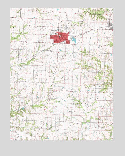
Slater, MO USGS Topographic Map
Click on map above to begin viewing in our Map Viewer.

This topographic map contains these locations and features:
Feature Name Type Latitude Longitude GNIS ID View Map
Brick School (historical)SchoolN39.1806°W93.1188°743558View Map
City of GilliamCivilN39.2327°W93.0041°2396960View Map
City of SlaterCivilN39.2227°W93.0650°2395896View Map
Clay Center School (historical)SchoolN39.1416°W93.0227°743564View Map
George School (historical)SchoolN39.1361°W93.0808°743572View Map
GilliamPopulated PlaceN39.2334°W93.0046°718453View Map
Gilliam Elementary SchoolSchoolN39.2358°W93.0039°2545407View Map
Gilliam Post OfficePost OfficeN39.2337°W93.0047°2782784View Map
Hickman CemeteryCemeteryN39.2110°W93.1225°719425View Map
Linn Grove School (historical)SchoolN39.1928°W93.0119°743578View Map
Mount Horeb CemeteryCemeteryN39.2111°W93.1180°722771View Map
Mount Horeb School (historical)SchoolN39.2117°W93.1249°743584View Map
Mount Moriah CemeteryCemeteryN39.2329°W93.0668°2702923View Map
Only Way Lake DamDamN39.2217°W93.0469°760370View Map
OrearvillePopulated PlaceN39.1717°W93.0744°741124View Map
Orearville Elementary SchoolSchoolN39.1714°W93.0689°743587View Map
Potter School (historical)SchoolN39.1624°W93.0179°743592View Map
SlaterPopulated PlaceN39.2181°W93.0691°726530View Map
Slater Alexander Elementary SchoolSchoolN39.2231°W93.0654°2545221View Map
Slater City CemeteryCemeteryN39.2311°W93.0580°2702902View Map
Slater City Fire DepartmentBuildingN39.2189°W93.0618°2620925View Map
Slater High SchoolSchoolN39.2237°W93.0653°2545256View Map
Slater LakeReservoirN39.2194°W93.0475°760371View Map
Slater Memorial AirportAirportN39.2276°W93.0740°758941View Map
Slater Police DepartmentBuildingN39.2201°W93.0594°2752267View Map
Slater Post OfficePost OfficeN39.2197°W93.0621°2783020View Map
Township of ClayCivilN39.1663°W93.0007°767360View Map

Note: Coordinates in the location and feature list above are referenced to NAD83 datum.


Copyright (C) 2008-2025 Ryan Niemi / Sunset Dynamics ... All Rights Reserved