TopoQuest Logo
Do you find TopoQuest useful?
Help keep TopoQuest running and adding new maps/features by donating!
Bitcoin:  19c7KJd3qBynnjoSw5npx9KScwjBe4ifkT
Litecoin:  LXs6TkuXGGXo1vDsWCkWVdjQX94eUKd6ui
Home View Maps Find Maps Find Places Resources & Links


San Felipe, California Topographic Map

USGS Map Title: San Felipe, CA
USGS Map MRC: 36121H4
DRG (GeoTIFF) Download: o36121h4.tif


Neighboring USGS Topographic Map Quads:


  Gilroy, CA  
37121A5
 

  Gilroy Hot Springs, CA  
37121A4
 

  Pacheco Peak, CA  
37121A3
 

  Chittenden, CA  
36121H5
 

  San Felipe, CA  
36121H4
 

  Three Sisters, CA  
36121H3
 

  San Juan Bautista, CA  
36121G5
 

  Hollister, CA  
36121G4
 

  Tres Pinos, CA  
36121G3


Map MRC Location:

N37°
W122°
N37°
W121°
H8 H7 H6 H5 H4 H3 H2 H1
G8 G7 G6 G5 G4 G3 G2 G1
F8 F7 F6 F5 F4 F3 F2 F1
E8 E7 E6 E5 E4 E3 E2 E1
D8 D7 D6 D5 D4 D3 D2 D1
C8 C7 C6 C5 C4 C3 C2 C1
B8 B7 B6 B5 B4 B3 B2 B1
A8 A7 A6 A5 A4 A3 A2 A1
N36°
W122°
N36°
W121°

San Felipe, CA USGS 1:24K Topographic Map Preview:
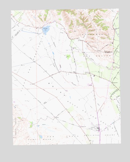
San Felipe, CA USGS Topographic Map
Click on map above to begin viewing in our Map Viewer.

This topographic map contains these locations and features:
Feature Name Type Latitude Longitude GNIS ID View Map
Almaden VineyardsLocaleN36.9677°W121.3841°1834908View Map
Arroyo De Las ViborasStreamN36.9172°W121.3897°233429View Map
Arroyo Dos PicachosStreamN36.9172°W121.3894°233434View Map
Ausaymas SchoolSchoolN36.9311°W121.3852°218464View Map
BolsaAreaN36.9252°W121.4516°233531View Map
Bolsa De San FelipeCivilN36.9044°W121.4130°219615View Map
Bureau of Land Management Hollister Field OfficeBuildingN36.8826°W121.3912°2624380View Map
Cascade Ruta WineryLocaleN36.9916°W121.3797°1834973View Map
Department of Forestry and Fire Protection Hollister Ranger StationBuildingN36.9628°W121.4189°2624588View Map
Don Pacheco GardensLocaleN36.9672°W121.3844°1835025View Map
DunnevillePopulated PlaceN36.9405°W121.4105°222739View Map
Fairhaven SchoolSchoolN36.8908°W121.4222°223334View Map
Flint HillsSummitN36.8786°W121.4683°223611View Map
Frazier Lake AirparkAirportN36.9529°W121.4671°1653529View Map
Hollister Business ParkLocaleN36.8869°W121.3949°1817417View Map
Hollister Municipal AirportAirportN36.8899°W121.4045°1653527View Map
Hollister Police DepartmentBuildingN36.8924°W121.3937°2755792View Map
Hollister ValleyValleyN36.9141°W121.4066°225455View Map
Hollister Wayside ParkParkN36.8852°W121.4008°1817418View Map
HudnerPopulated PlaceN36.9000°W121.4513°1658796View Map
Llano Del TequisquitaCivilN36.9522°W121.4810°227441View Map
Millers CanalCanalN36.9644°W121.4899°228753View Map
Naval Auxiliary Air Station Hollister (historical)MilitaryN36.8906°W121.4072°2061755View Map
Ortega CreekStreamN36.9841°W121.4558°255002View Map
Pacheco CreekStreamN36.9772°W121.4602°230193View Map
Pacheco Pass LandfillLocaleN36.9950°W121.4797°2726516View Map
Pacheco SchoolSchoolN36.9408°W121.4272°230199View Map
Prunedale School (historical)SchoolN36.9949°W121.4999°1670495View Map
San Benito County JailBuildingN36.8839°W121.4117°2739937View Map
San Benito County Sheriff's OfficeBuildingN36.8907°W121.3988°2755826View Map
San FelipePopulated PlaceN36.9708°W121.4191°252786View Map
San Felipe LakeLakeN36.9804°W121.4623°232386View Map
San Felipe School (historical)SchoolN36.9730°W121.4269°1670496View Map
Santa Ana CreekStreamN36.9283°W121.4149°232534View Map
Santa Clara TunnelLocaleN36.9844°W121.4031°2680164View Map
Tequisquita SloughStreamN36.9788°W121.4635°236122View Map
Vessey 654 DamDamN36.8950°W121.4677°1664006View Map

Note: Coordinates in the location and feature list above are referenced to NAD83 datum.


Copyright (C) 2008-2025 Ryan Niemi / Sunset Dynamics ... All Rights Reserved