TopoQuest Logo
Do you find TopoQuest useful?
Help keep TopoQuest running and adding new maps/features by donating!
Bitcoin:  19c7KJd3qBynnjoSw5npx9KScwjBe4ifkT
Litecoin:  LXs6TkuXGGXo1vDsWCkWVdjQX94eUKd6ui
Home View Maps Find Maps Find Places Resources & Links


San Mateo, Florida Topographic Map

USGS Map Title: San Mateo, FL
USGS Map MRC: 29081E5
DRG (GeoTIFF) Download: o29081e5.tif


Neighboring USGS Topographic Map Quads:


  Palatka, FL  
29081F6
 

  Hastings, FL  
29081F5
 

  Spuds, FL  
29081F4
 

  Satsuma, FL  
29081E6
 

  San Mateo, FL  
29081E5
 

  Dinner Island, FL  
29081E4
 

  Welaka, FL  
29081D6
 

  Crescent City, FL  
29081D5
 

  Saint Johns Park, FL  
29081D4


Map MRC Location:

N30°
W82°
N30°
W81°
H8 H7 H6 H5 H4 H3 H2 H1
G8 G7 G6 G5 G4 G3 G2 G1
F8 F7 F6 F5 F4 F3 F2 F1
E8 E7 E6 E5 E4 E3 E2 E1
D8 D7 D6 D5 D4 D3 D2 D1
C8 C7 C6 C5 C4 C3 C2 C1
B8 B7 B6 B5 B4 B3 B2 B1
A8 A7 A6 A5 A4 A3 A2 A1
N29°
W82°
N29°
W81°

San Mateo, FL USGS 1:24K Topographic Map Preview:
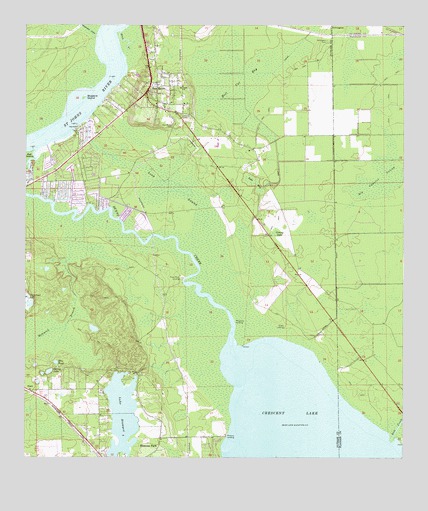
San Mateo, FL USGS Topographic Map
Click on map above to begin viewing in our Map Viewer.

This topographic map contains these locations and features:
Feature Name Type Latitude Longitude GNIS ID View Map
Acosta GrantCivilN29.5789°W81.5990°303939View Map
Blue PondLakeN29.5277°W81.6145°279050View Map
BNCFL AirportAirportN29.5794°W81.5918°2770286View Map
Bray CreekGutN29.6208°W81.5915°279346View Map
Buzzard IslandIslandN29.6044°W81.6056°279764View Map
Church of GodChurchN29.5961°W81.5964°2452253View Map
Clarke and Atkinson GrantCivilN29.5711°W81.5709°303940View Map
Dunns Creek Baptist ChurchChurchN29.5923°W81.6011°2452254View Map
Farm Service Agency Interest of FloridaParkN29.6045°W81.5400°2776753View Map
G W Perpall GrantCivilN29.6247°W81.6242°303937View Map
Grassy LakeSwampN29.5654°W81.5416°283329View Map
Hammock BranchChannelN29.5416°W81.6084°283647View Map
Hell Cat BaySwampN29.6103°W81.5567°283873View Map
Job Wiggins GrantCivilN29.5950°W81.5831°303938View Map
John Broward GrantCivilN29.5447°W81.6037°308579View Map
Lake BrowardLakeN29.5126°W81.5924°279466View Map
Lake MaySwampN29.5805°W81.5503°286541View Map
Long SwampSwampN29.5597°W81.5612°286081View Map
Moccasin LandingLocaleN29.5397°W81.5551°295457View Map
Mount Tabor ChurchChurchN29.6077°W81.5729°287326View Map
Piney Bluff LandingLocaleN29.5519°W81.5726°295544View Map
Pomona LandingAirportN29.5042°W81.5763°2676678View Map
Pomona LandingLocaleN29.5066°W81.5584°295552View Map
Pomona ParkPopulated PlaceN29.5002°W81.5915°289160View Map
Salt CreekStreamN29.5052°W81.5040°290432View Map
San MateoPopulated PlaceN29.6066°W81.5845°290487View Map
San Mateo CemeteryCemeteryN29.5964°W81.5754°290489View Map
San Mateo Fire Department Station 19BuildingN29.5821°W81.6152°2644103View Map
San Mateo Post OfficePost OfficeN29.6076°W81.5831°2768225View Map
San Mateo TowerTowerN29.5986°W81.5729°303941View Map
Shell Hill PointCapeN29.5111°W81.5570°295035View Map
Spring LakeLakeN29.5250°W81.6167°291553View Map
Sutherlands StillPopulated PlaceN29.5736°W81.6031°297378View Map
Sykes CoveBayN29.5289°W81.5319°295036View Map
Sykes LandingLocaleN29.5377°W81.5390°295663View Map
Town of Pomona ParkCivilN29.5015°W81.5938°2407145View Map
Willow CoveBayN29.5283°W81.5568°295037View Map
Willow PointCapeN29.5205°W81.5567°295038View Map
Yelvington CemeteryCemeteryN29.6208°W81.5251°293589View Map

Note: Coordinates in the location and feature list above are referenced to NAD83 datum.


Copyright (C) 2008-2024 Ryan Niemi / Sunset Dynamics ... All Rights Reserved